

Brighter Today; Rain Returns Thursday Night
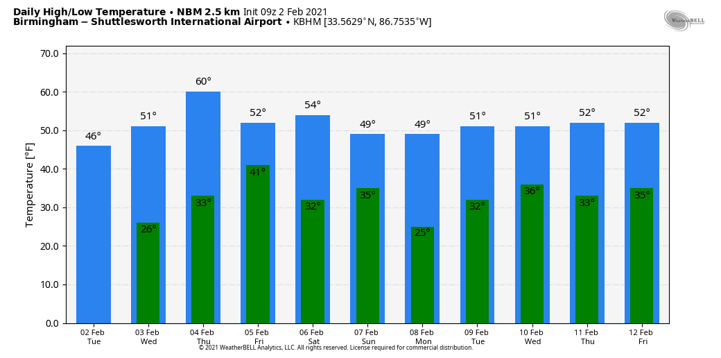
BRIGHTER DAY: We expect a good supply of sunshine across Alabama today, but temperatures will remain below average with a cool north breeze. The high today will in the 45-48 degree range; the average high for Birmingham on February 2 is 56. Tonight will be clear and cold… we drop into the upper 20s early tomorrow morning. Then, during the day tomorrow, look for a sunny sky with a high in the low 50s.
RAIN RETURNS: The day Thursday will be dry, although clouds increase late in the day. Temperatures reach 60 degrees Thursday afternoon… it will be our warmest day of the week. A cold front will bring rain to the state Thursday night; no risk of severe storms, and probably no thunder. Rain amounts will be generally 1/2 inch or less, and the rain will end early Friday morning. The sky becomes partly to mostly sunny during the day Friday with a high between 48 and 52 degrees.
THE ALABAMA WEEKEND: The day Saturday will be dry… we are forecasting a partly sunny sky with a high in the low 50s. Clouds will move back in Saturday night, and some light rain is likely after midnight into Sunday morning ahead of an Arctic front. Moisture will be limited, and rain amounts should be a quarter inch or less for most places. Much colder air will blow into the state Sunday afternoon and Sunday night, most likely the coldest air so far this season. A few snow flurries are possible over North Alabama as the cold air rushes in, but for now no impact or accumulation is expected. Temperatures will fall into the 30s over the Tennessee Valley, with low 40s for the I-20 corridor.
MONDAY: A hard freeze is likely Monday morning. Models have backed off a bit on the intensity of the cold air for Alabama, suggesting the coldest air will pass just north and east of here. But we still project lows in the 15-25 degree range, and some colder North Alabama communities could be closer to 10 degrees. Then, during the day Monday, the high will be in the 40s with a sunny sky.
REST OF NEXT WEEK: Tuesday and Wednesday look dry for now; global models now show the next wave impacting the state Thursday. For now it looks like mostly rain, but it is simply too early to call. See the Weather Xtreme video for maps, graphics, and more details.
ON THIS DATE IN 1985: A major ice storm crippled Northwest Alabama. Roofs collapsed on three businesses in the Florence area and numerous carports and awnings fell victim to the weight of the sleet and snow. Roads were closed in the Florence area. Most Huntsville television stations were off the air. About 600 motorists were stranded between Birmingham and Cullman on I-65, forcing travelers to spend the night in shelters. It was the worst winter storm since 1963 in Northwest Alabama. US-78 northwest of Birmingham was a skating rink with numerous accidents being reported. An ambulance carrying wreck victims to Carraway Hospital overturned, injuring the crew. Four people died as a result of the winter storm in Alabama.
BEACH FORECAST: Click here to see the AlabamaWx Beach Forecast Center page.
WEATHER BRAINS: Don’t forget you can listen to our weekly 90 minute show anytime on your favorite podcast app. This is the show all about weather featuring many familiar voices, including our meteorologists here at ABC 33/40.
CONNECT: You can find me on all of the major social networks…
Look for the next Weather Xtreme video here by 3:00 this afternoon… enjoy the day!
Category: Alabama's Weather, ALL POSTS, Weather Xtreme Videos
About the Author (Author Profile)
James Spann is one of the most recognized and trusted television meteorologists in the industry. He holds the AMS CCM designation and television seals from the AMS and NWA. He is a past winner of the Broadcast Meteorologist of the Year from both professional organizations.Subscribe
If you enjoyed this article, subscribe to receive more just like it.


