

Rain At Times Over The Weekend
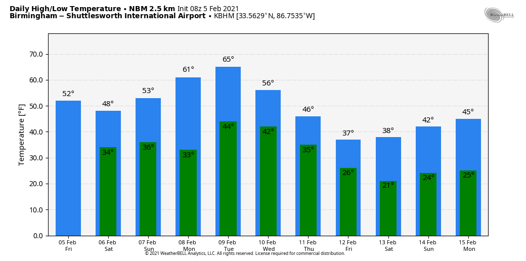
RADAR CHECK: Rain continues this morning ahead of a cold front south of a line from Thomasville to Montgomery to Lafayette. The front will continue to drift southward this morning, and the best chance of showers today will be confined to the southern quarter of the state. North/Central Alabama will be dry with a partially sunny sky… the high will be in the low 50s for most communities.
THE ALABAMA WEEKEND: A wave of low pressure along the front will bring a cold rain to much of the state tomorrow. For the northern and central counties, most of the rain comes tomorrow afternoon and tomorrow night with temperatures only in the 30s and 40s. The combination of evaporative and dynamic cooling could very well lead to some snow for parts of the Tennessee Valley of far North Alabama, especially the northeast corner of the state. For now it looks like temperatures will be just above freezing, in the mid 30s, so while some grassy areas could become white, travel impact is not expected. But, it is a close call and watch for updates if you live in counties like Madison, Jackson, Marshall, DeKalb, and Cherokee.
Rain amounts of 1/2 inch or less and forecast, and the rain ends late tomorrow night. Sunday will be dry… the sky will be partly sunny with a high in the low 50s.
NEXT WEEK: High temperatures will rise into the low to mid 60s during the first half of the week. Monday will be dry, but a little scattered light rain is possible Tuesday and Wednesday as moisture levels begin to rise again. Rain becomes more likely Thursday as a shallow layer of much colder air moves into the state from the north.
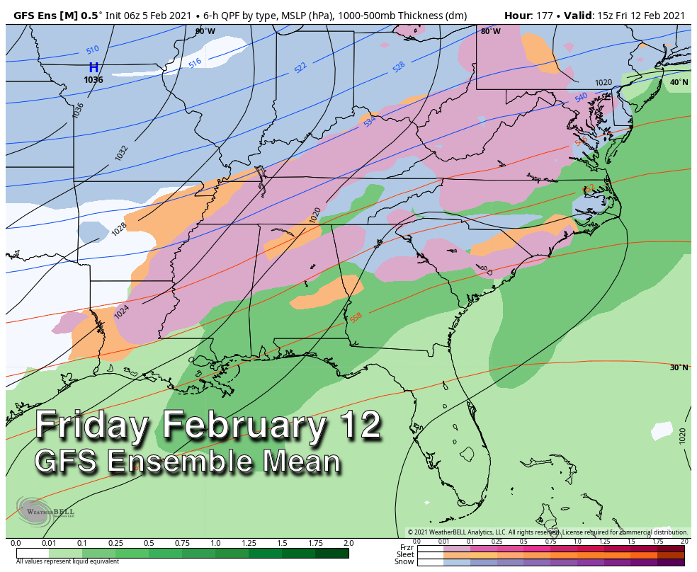
ICE PROBLEMS? Precipitation will likely continue Thursday night into Friday, and there is a very real possibility that freezing rain becomes an issue for parts of the Deep South. That is rain in liquid form that falls with surface temperatures at or below freezing, and can lead to a coating of ice on exposed surfaces. All of the ingredients are on the table for this kind of event, but there is no way of knowing location of the highest impact, and it is simply too early for a specific forecast. It is beyond the science.
For any given location in Alabama, Friday’s weather range of possibilities goes from cold and dry, to a cold rain, or to a high impact winter weather event. Don’t focus too much on the deterministic model runs, they will flip and flop a good bit over the weekend. Output from the global model ensembles have been pretty consistent in forecast potential for freezing rain. Some decent skill will begin in forecasting the event on Monday; we will keep you updated right here.
One way or another, our weather looks very cold late next week and into the following weekend… easily the coldest air so far this winter. See the Weather Xtreme video for maps, graphics, and more details.
ON THIS DATE IN 1887: San Francisco experienced its most significant snowstorm of record. Nearly four inches was reported in downtown San Francisco, and the western hills of the city received seven inches. Excited crowds went on a snowball throwing rampage.
ON THIS DATE IN 1986: A supercell thunderstorm tracked through the Tomball area northwest of Houston, TX, and produced four tornadoes along with damaging microburst winds and up to tennis ball size hail. An F3 tornado killed two people, injured 80 others, and devastated a mobile home park and the David Wayne Hooks Airport.
BEACH FORECAST: Click here to see the AlabamaWx Beach Forecast Center page.
WEATHER BRAINS: Don’t forget you can listen to our weekly 90 minute show anytime on your favorite podcast app. This is the show all about weather featuring many familiar voices, including our meteorologists here at ABC 33/40.
CONNECT: You can find me on all of the major social networks…
Look for the next Weather Xtreme video here by 3:00 this afternoon… enjoy the day!
Category: Alabama's Weather, ALL POSTS, Weather Xtreme Videos
About the Author (Author Profile)
James Spann is one of the most recognized and trusted television meteorologists in the industry. He holds the AMS CCM designation and television seals from the AMS and NWA. He is a past winner of the Broadcast Meteorologist of the Year from both professional organizations.Subscribe
If you enjoyed this article, subscribe to receive more just like it.


