

Spring-Like Through Mid-Week; Colder This Weekend
ON THE MAPS: We have a complex winter weather pattern this morning, with the “polar vortex” cover Canada. This has pulled bitterly cold Arctic air down into the northern U.S… International Falls, MN reports -20F early this morning with a wind chill index of -35F. Under the vortex we have an active southern branch of the jet stream, pushing a series of waves along in the fast flow.
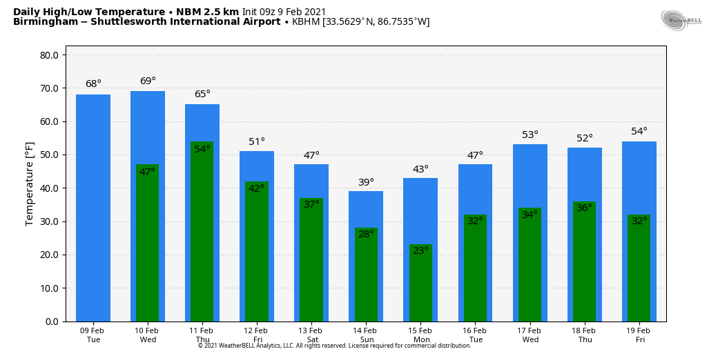
One of those waves is producing a large area of rain and thunderstorms over the southeast half of Alabama early this morning… that rain will be out of the state by mid-morning, and most of the day today will be dry with temperatures this afternoon reaching the 67-70 degree range. The average high for Birmingham on February 9 is 57. Clouds this morning will give way to a partly sunny afternoon over the northern half of the state.
The weather stays very mild tomorrow with a high not too far from 70 degrees; the sky will be mostly cloudy, and we will mention some risk of scattered showers as moisture levels begin to rise. But, most of the day will be dry.
THURSDAY/FRIDAY: Rain becomes widespread across Alabama Thursday and Thursday night ahead of the Arctic front. Thunderstorms are possible, but severe storms are not expected as the higher shear values will be on the north side of the front in the colder air. Rain amounts will be around one inch, and the high Thursday will be in the 60s. Then, much colder air slips into North Alabama Friday. The sky will be mostly cloudy, and we expect highs in the 40s over the northern half of the state. Showers remain possible Friday over South Alabama, where temperatures will rise into the 60s again.
THE ALABAMA WEEKEND: Yet another wave in the southern stream will bring a cold rain to Alabama Saturday. Temperatures will be in the 40s over the northern counties, with 50s to the south. The rain ends Saturday night… there remains some outside risk of a brief period of freezing rain for North Alabama, but for now it looks like most of the rain will be over by the time sub-freezing temperatures arrive. Sunday will be mostly cloudy and cold with temperatures holding in the 30s over North Alabama, with 40s for the southern counties.
NEXT WEEK: The day Monday will be dry, but the next wave brings precipitation back into the state Monday night and early Tuesday. Global models are hinting at some risk of freezing rain for parts of North Alabama with this event, but in a complex pattern seven days out it is simply too early to call. The latter half of the week looks dry for now with temperatures remaining below average. See the Weather Xtreme video for maps, graphics, and more details.
NOTE: Another reminder global models don’t really have the grid resolution to handle shallow layers of cold air, and with an active southern branch of the jet understand forecast changes are to be expected in this pattern. Keep an eye on the blog for forecast updates.
ON THIS DATE IN 1994: A devastating ice storm struck Mississippi, Louisiana and extreme northwest Alabama. Freezing rain began falling over North Mississippi during the early morning hours and continued until midday on the 10th. Ice accumulated 3 to 6 inches thick on exposed objects in the affected area. Due to the weight of the ice, power lines, trees and tree limbs were downed. Nearly one million people were without power after the storm, some for a month.
BEACH FORECAST: Click here to see the AlabamaWx Beach Forecast Center page.
WEATHER BRAINS: Don’t forget you can listen to our weekly 90 minute show anytime on your favorite podcast app. This is the show all about weather featuring many familiar voices, including our meteorologists here at ABC 33/40.
CONNECT: You can find me on all of the major social networks…
Look for the next Weather Xtreme video here by 3:00 this afternoon… enjoy the day!
Category: Alabama's Weather, ALL POSTS, Weather Xtreme Videos
About the Author (Author Profile)
James Spann is one of the most recognized and trusted television meteorologists in the industry. He holds the AMS CCM designation and television seals from the AMS and NWA. He is a past winner of the Broadcast Meteorologist of the Year from both professional organizations.Subscribe
If you enjoyed this article, subscribe to receive more just like it.


