

Cold, Unsettled Weather Ahead For Alabama
THIS AFTERNOON: It is a cloudy and cold day for most of the state… the Arctic front is just southeast of Montgomery. At mid-afternoon temperatures range from 34 at Haleyville to 66 at Dothan, an impressive 32 degree spread on either side of the front. We have some patches of light rain and drizzle in progress, but a decent part of the state is dry.
TONIGHT/TOMORROW: Rain becomes more widespread late tonight and tomorrow across the state, and some freezing rain or freezing drizzle is possible across the northwest part of the state, where temperatures will be in the 29-32 degree range. Be aware that bridges could become icy late tonight and tomorrow morning in places like Florence, Russellville, Hamilton, Sulligent, Haleyville, Moulton, Athens, Decatur, and Huntsville. For most of the state, however, it will just a cold rain late tonight and tomorrow morning.
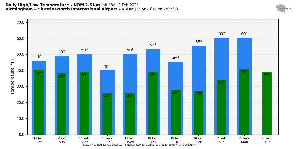
Temperatures tomorrow will be similar to those we are seeing today… 30s for the northern counties, 40s for Central Alabama, and 50s to the south.
SUNDAY/MONDAY: Cloudy, cold, unsettled weather continues. Some patchy light rain or drizzle is possible during the day, including a chance of freezing drizzle for the northwest counties again. The chance of precipitation will slowly increase Sunday night, into Monday and Monday evening. While most of Alabama will see a cold rain, there is potential for freezing rain and ice accumulation for parts of North and West Alabama in the shallow layer of cold air over that region.
The best chance of freezing rain and ice is along and north of a line from Livingston to Tuscaloosa to Huntsville. For now it looks like just a cold rain for cities like Birmingham, Anniston, and Gadsden. But, where freezing rain falls over North and West Alabama, ice could disrupt travel due to icy roads and bridges, and it could also result in some falling tree limbs and branches bringing scattered power outages. This won’t be an historic ice storm, but out doesn’t take much ice to become very disruptive.
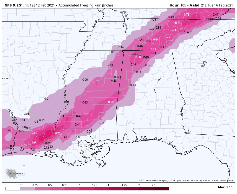
NOTE: Understand this forecast can, and probably will change in coming days. There is inherent uncertainty in any weather weather forecast for Alabama, especially in this kind of pattern. Also know that the boundary between a cold rain, and freezing rain/ice accumulation is never a straight line like you see on maps, identifying that boundary is always a challenge.
REST OF NEXT WEEK: Tuesday and Wednesday will be dry but cold. Rain returns Thursday, and there is some chance the rain could change briefly to light snow or snow flurries Thursday night or Friday in a new surge of colder air, but for now it looks like little chance of any major impact. See the Weather Xtreme video for maps, graphics, and more details.
ON THIS DATE IN 1958: Snow blanketed northern Florida, with Tallahassee reporting a record 2.8 inches. A ship in the Gulf of Mexico, 25 miles south of Fort Morgan Alabama, reported zero visibility in heavy snow on the afternoon of the 12th.
BEACH FORECAST: Click here to see the AlabamaWx Beach Forecast Center page.
WEATHER BRAINS: Don’t forget you can listen to our weekly 90 minute show anytime on your favorite podcast app. This is the show all about weather featuring many familiar voices, including our meteorologists here at ABC 33/40.
CONNECT: You can find me on all of the major social networks…
Look for my next Weather Xtreme video here by 6:00 a.m. Monday… enjoy the weekend!
Category: Alabama's Weather, ALL POSTS, Weather Xtreme Videos
About the Author (Author Profile)
James Spann is one of the most recognized and trusted television meteorologists in the industry. He holds the AMS CCM designation and television seals from the AMS and NWA. He is a past winner of the Broadcast Meteorologist of the Year from both professional organizations.Subscribe
If you enjoyed this article, subscribe to receive more just like it.


