

Conditions Improve Later Today, Potential Icing Issues on Monday
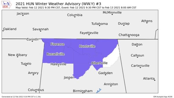
• NWS Huntsville continues a Winter Weather Advisory until 10:00 am for Colbert, Cullman, Franklin, Jackson, Lauderdale, Lawrence, Limestone, Madison, Marshall, and Morgan counties in North Alabama.
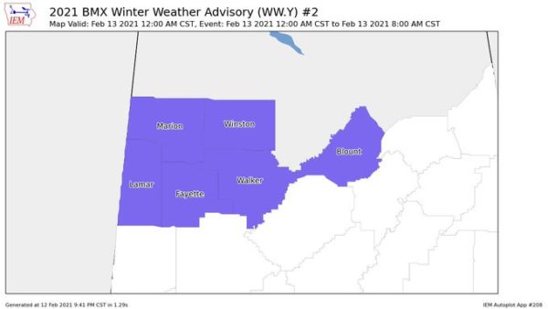
• NWS Birmingham continues a Winter Weather Advisory until 10:00 am for Blount, Fayette, Lamar, Marion, Walker, and Winston counties in Central Alabama.
If you are having to drive this morning, leave early and slow down. Hazardous travel will persist through the morning in the advisory area. Icy bridges & overpasses have been reported along with light glaze of ice on elevated surfaces including vehicles.
TODAY: After the morning temperatures start to warm above freezing in the advisory area, any ice accumulations will melt and any travel issues will clear up this morning. Shower activity will eventually come to an end by the early to mid-afternoon hours, but skies will generally stay cloudy throughout the rest of the day. Afternoon highs will be in the upper 30s to the upper 50s across the area from northwest to southeast.
SUNDAY: Much of your Valentine’s Day (yes, that’s Sunday, guys) will remain mainly dry across much of Central Alabama but don’t expect much sunshine at all. Showers will eventually become possible once again by the late-night and overnight hours over the northern half of the area. Some freezing rain may be possible for the northwestern parts of the area but any accumulations are unknown at this time. Highs will be in the upper 30s to the upper 50s across the area from northwest to southeast.
MONDAY: Much of Monday morning looks to be dry, but showers and the potential for freezing rain and sleet will begin to move into the western parts of the area before midday. It is still a tricky situation to forecast because it all depends on temperature, the intensity of the rainfall, and ground temperatures if there will be any ice accumulations. At this point, the best probability for accumulating ice will be along and west of a line from Livingston to Jasper to Fort Payne. South and east of that line will be just a cold rain for the rest of the area.
The European is similar in its latest projections, but the timing has the freezing rain starting mid-afternoon and persisting through the late-night hours, with all activity out of the area by midnight.
Some travel issues may be possible in those locations where accumulations may occur, especially on bridges, overpasses, and any other elevated surfaces. While all of the activity will be out of the area just before midnight, overnight lows may allow any accumulated ice to stick around through the overnight hours. Highs will top out in the mid-30s to the lower 60s across the area from northwest to southeast, but eventually dropping into the upper teens to the mid-30s for the overnight lows.
TUESDAY: Those icing issues may hang around through the morning hours on Tuesday as it will take a while for those locations to make it above freezing. Skies will eventually become mostly clear by the evening hours and highs look to top out in the lower 30s to the lower 50s across the area from northwest to southeast.
WEDNESDAY: The good news is that Wednesday will be a little warmer and there will not be any icing issues. Unfortunately, clouds will be working back into Central Alabama throughout the day, and showers will become possible by the evening hours. Highs will be in the lower 40s to the lower 60s.
THURSDAY: Thursday still looks to be a really wet day across Central Alabama as a surface low will be working its way northeastward through the western parts of the area throughout the day. At this point, severe weather does not look likely, but there will be enough instability that a few rumbles of thunder will be possible. Highs will top out in the mid-40s to the mid-60s across the area from northwest to southeast.
FRIDAY: Shower activity will be moving out of the area before sunrise on Friday morning and we’ll be left with decreasing clouds and cooler temperatures behind the low and departing cold front. Highs will be in the lower 40s to the lower 50s.
Category: Alabama's Weather, ALL POSTS, Weather Xtreme Videos, Winter Weather
About the Author (Author Profile)
Scott Martin is an operational meteorologist, professional graphic artist, musician, husband, and father. Not only is Scott a member of the National Weather Association, but he is also the Central Alabama Chapter of the NWA president. Scott is also the co-founder of Racecast Weather, which provides forecasts for many racing series across the USA. He also supplies forecasts for the BassMaster Elite Series events including the BassMaster Classic.Subscribe
If you enjoyed this article, subscribe to receive more just like it.


