

Winter Storm Ahead For North and West Alabama
A potent winter storm will impact much of North and West Alabama tomorrow and tomorrow night with potential for enough ice accumulation for major travel impact and power outages.
WATCHES/WARNINGS: A winter storm warning has been issued for these counties: Marengo, Sumter, Greene, Hale, Tuscaloosa, Pickens, Lamar, Fayette, Walker, Cullman, Winston, Marion, Franklin, Colbert, Lauderdale, Lawrence, Limestone, Madison, Morgan, Marshall, Jackson, and DeKalb. A winter storm watch has been issued for Perry, Bibb, Jefferson, Shelby, and Blount counties. Winter weather advisories are in effect for Choctaw, Clarke, and Washington counties in Southwest Alabama.
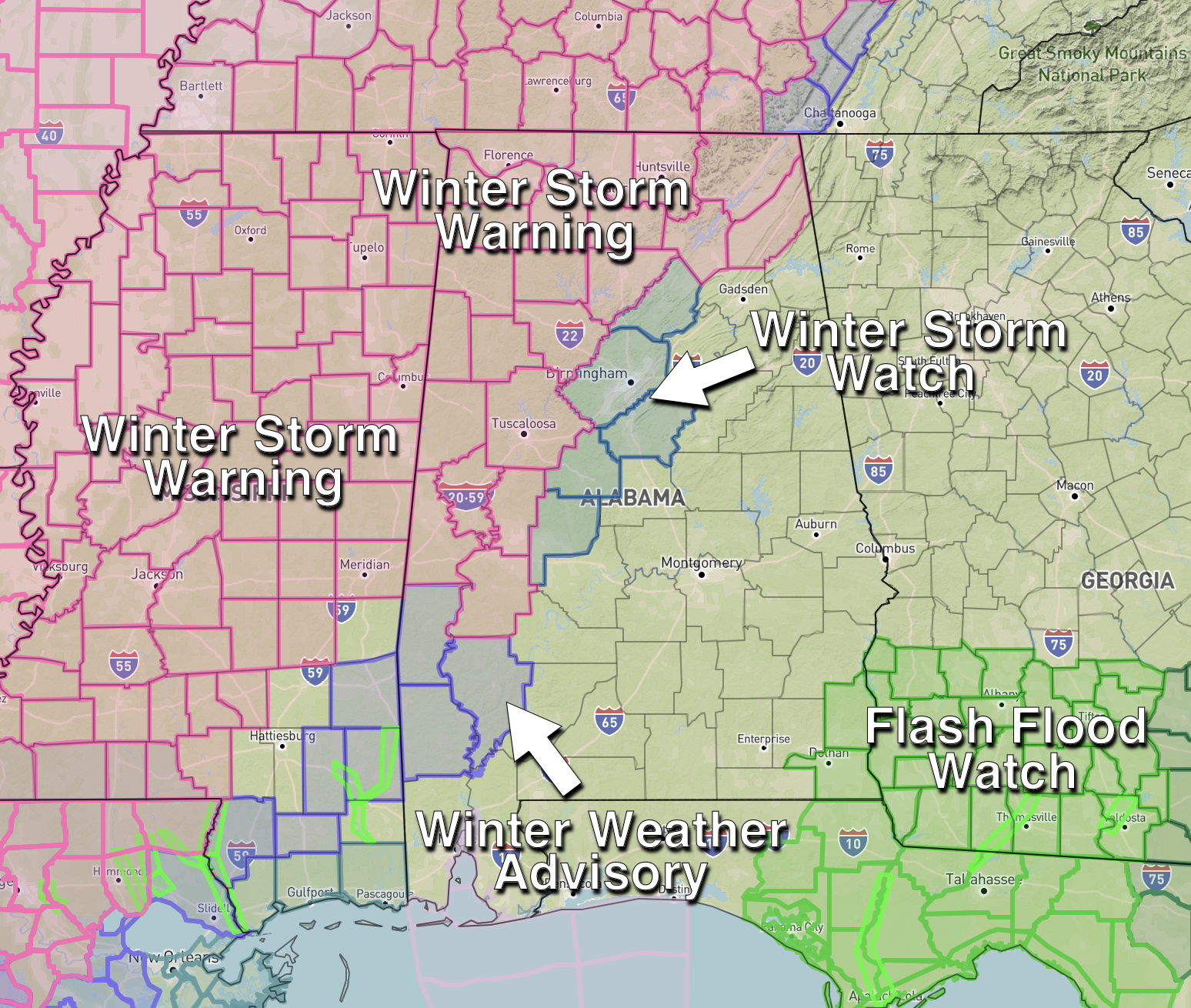
PLACEMENT: The main impact will come in the winter storm warning area, which is most of North and West Alabama. As a “course of least regret”, NWS has added the Birmingham metro into a winter storm watch. Precipitation in Jefferson and Shelby counties will be mostly in the form of cold rain initially with temperatures a little above freezing, but as they fall Monday night “black ice” will likely become a problem and could bring a glaze of ice to bridges and some roads.
For now a cold rain is forecast with no impact for East Alabama, including places like Anniston and Gadsden.
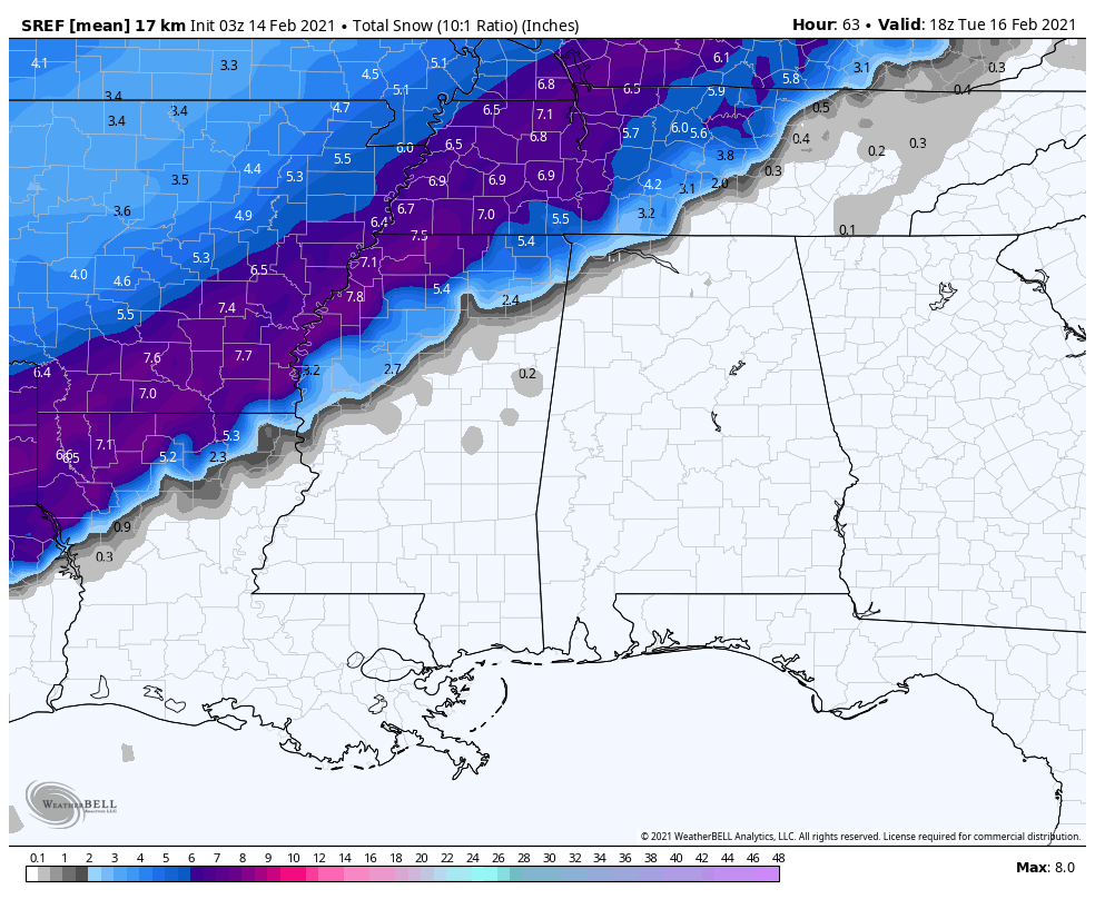
We should mention snow is a good possibility across the northwest corner of Alabama, where the cold air will be deeper. Places like Florence, Muscle Shoals, and Russellville could see 2-3 inches of snow with this event. Some snow is possible as far southeast as Hamilton and Haleyville. But again, for most of those in the winter storm warning, it will be mostly freezing rain and some sleet.
TIMING: The precipitation will come in two phases. The first round will come tonight; freezing rain or drizzle is possible for North and West Alabama as early as 6:00 p.m… and will continue at times through daybreak tomorrow. This will be fairly light, but it won’t take much for bridges to become icy.
The “main show” comes late tomorrow morning through tomorrow night, when freezing rain will become heavier and more widespread across the winter storm warning area. Travel conditions will continue to deteriorate, and ice accumulation will increase on exposed surfaces, including trees and power lines. Precipitation will be over by 10:00 tomorrow night for most of Alabama.
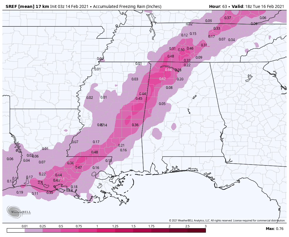
IMPACT: The big issue will be freezing rain in the winter storm warning area, but some sleet is possible, if not likely as well in spots. Ice accumulation of .10” to .25” is likely, with isolated amounts to .50”. Travel will become difficult, if not impossible in many areas due to ice on bridges and road surfaces. Power outages are likely where heavier freezing rain falls. This is a significant ice storm threat.
Temperatures will drop into the 10-18 degree range late tomorrow night and early Tuesday morning… with wind chills ranging from 0-10. Some parts of North and West Alabama could remain below freezing Tuesday, meaning travel issues will likely persist through midday Wednesday in the winter storm warning area.
REMEMBER: A difference of a few degrees determines whether you have an ice storm, or a cold rain. This boundary won’t be in a straight line like the maps we show you… they are simply a guideline. But understand in some places on the eastern side of the winter storm warning, one side of town will see rain with no impact, but your neighbors could be on ice to the west.
And, more forecast adjustments are possible as we see how the system unfolds to the west today. Keep up with the latest updates here… if you are working with old weather information, you are working with bad information.
PREPARE NOW: If you are in the winter storm warning area, you have less than 24 hours to get ready.
*Be sure all of your phones, tablets, and other devices are fully charged.
*Travel is highly discouraged where ice accumulates. If you MUST travel, create an emergency supply kit for your car. Include jumper cables, sand, a flashlight, warm clothes, blankets, bottled water and non-perishable snacks. Keep a full tank of gas. Have cat litter or sand to help tires get traction, or road salt to melt ice
*Gather supplies in case you need to stay home for several days without power. Keep in mind each person’s specific needs, including medication. Remember the needs of your pets. Have extra batteries for radios and flashlights.
*Turn your refrigerator and freezer to their coldest settings.
*If you lose power and you plug a generator into the house electrical system, turn the main off in the breaker box. Otherwise it can be very dangerous for the crews working to restore power.
*Understand some could be without power for more than 24 hours with very cold, sub-freezing temperatures. Have an alternative source of heat. And, use it safely.
Watch for updates through the day today!
Category: Alabama's Weather, ALL POSTS
About the Author (Author Profile)
James Spann is one of the most recognized and trusted television meteorologists in the industry. He holds the AMS CCM designation and television seals from the AMS and NWA. He is a past winner of the Broadcast Meteorologist of the Year from both professional organizations.Subscribe
If you enjoyed this article, subscribe to receive more just like it.


