

A Quick Check on Our Icy Threat as of 9:00 pm
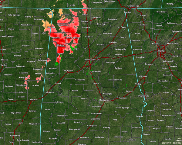
Freezing rain mixed with sleet continue to fall over the northwestern parts of the area at 9:00 pm, while the rest of North/Central is precipitation-free. Temperatures are in the upper 20s to the lower 30s in that northwestern quadrant of the area where the precipitation is falling. The rest of the area is above freezing.
Accumulations have been reported in Lamar and Marion counties in Central Alabama, and up into Colbert, Franklin, Lauderdale, and Lawrence counties in North Alabama. Several accidents have already been reported on the roadways in those general areas. Please stay off the road if you can help it.
There is a possibility that this activity may transition into more of a mix of sleet and snow as we go through the evening. Accumulations of 0.10 to 0.15 inches of ice are possible mainly west of I-65 and as far south as Lamar, Fayette, and Pickens counties. When the additional wintry precipitation moves in on Monday, that action will accumulate on what occurs tonight due to temperatures staying below freezing. Temperatures are not expected to get above freezing again until Wednesday afternoon.
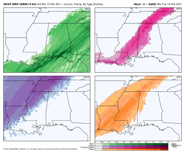
The latest run of the WRF model verifies with what both NWS offices (Birmingham and Huntsville) are thinking about with their latest projections of the ice accumulations (displayed in the top right corner in the shades of pink). Since temperatures are running a little colder than first projected, some sleet accumulations will be possible as well (bottom right in the orange shades). Light snow may accumulate over the extreme northwestern parts of the area as temperatures drop even further below freezing and will the precipitation to change over (lower left in the shades of purple).
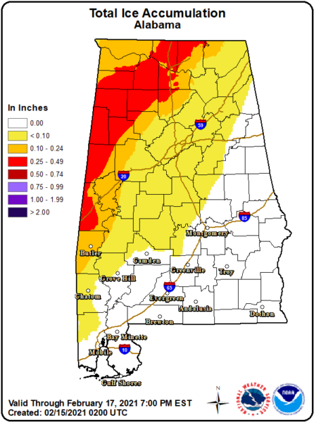
What’s impressive with this system is that there is a potential of ice accumulations all the way down to the northwestern parts of Mobile County. In the red areas on the map, ice accumulations could reach up to 1/2-inch. Amounts that high will more than likely cause some power issues due to ice on trees and power lines. Some weaker trees, branches, and limbs may fall. This is a very dynamic system and I wouldn’t be surprised if it over performs a bit.
Once again, before the main event hits, here are a few things that you can do to be ready and if your power does go out:
Make sure your phones, tablets, and other devices are fully charged.
Travel is highly discouraged, but if you have to travel due to an emergency, be sure to pack an emergency kit (jumper cables, sand or kitty litter, flashlight, warm clothes and blankets, bottled water, and non-perishable snacks).
Set your refrigerator and freezer to the coldest settings.
If you lose power and need to use a generator, be sure to turn the main off in the breaker box before you plug it in.
Have a safe alternate heat source. Some may lose power for more than 24 hours and overnight lows are expected to be in the teens and 20s.
We’ll continue with updates throughout this wintry event.
Category: Alabama's Weather, ALL POSTS, Winter Weather
About the Author (Author Profile)
Scott Martin is an operational meteorologist, professional graphic artist, musician, husband, and father. Not only is Scott a member of the National Weather Association, but he is also the Central Alabama Chapter of the NWA president. Scott is also the co-founder of Racecast Weather, which provides forecasts for many racing series across the USA. He also supplies forecasts for the BassMaster Elite Series events including the BassMaster Classic.Subscribe
If you enjoyed this article, subscribe to receive more just like it.


