

Strong Storms Affecting Lowndes & Montgomery Counties
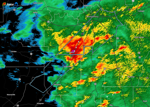
…SIGNIFICANT WEATHER ADVISORY FOR SOUTHEASTERN LOWNDES AND
MONTGOMERY COUNTIES UNTIL 200 PM CST…
At 118 PM CST, Doppler radar was tracking a strong thunderstorm over
Logan, or near Fort Deposit, moving northeast at 65 mph.
Pea size hail and winds in excess of 40 mph will be possible with
this storm.
Locations impacted include…
Montgomery, Fort Deposit, Pike Road, Hyundai Motors Of Alabama,
Auburn University In Montgomery, Snowdoun, Sellers, Davenport, Ramer,
Waugh, Lagoon Park, Pintlala, Lowndes County Airport, Alabama State
University, Strata, Naftel, Hope Hull, Mount Meigs, Eastdale Mall and
Logan.
PRECAUTIONARY/PREPAREDNESS ACTIONS…
To report severe weather, contact your nearest law enforcement
agency. They will relay your report to the National Weather Service
office in Birmingham.
Category: Alabama's Weather, ALL POSTS, Severe Weather
About the Author (Author Profile)
Scott Martin is an operational meteorologist, professional graphic artist, musician, husband, and father. Not only is Scott a member of the National Weather Association, but he is also the Central Alabama Chapter of the NWA president. Scott is also the co-founder of Racecast Weather, which provides forecasts for many racing series across the USA. He also supplies forecasts for the BassMaster Elite Series events including the BassMaster Classic.Subscribe
If you enjoyed this article, subscribe to receive more just like it.


