

Wet Start To The Day; Drier This Afternoon
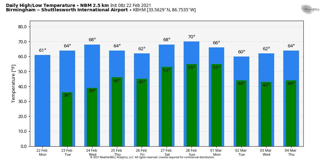
RADAR CHECK: Large areas of mostly light rain are moving across Alabama early this morning with temperatures mostly in the 50s. Rain will end from northwest to southeast during the midday hours, and some clearing is possible this afternoon as drier air moves back into the state. The high today will be in the low to mid 60s for most communities… the average high for Birmingham on February 22 is 60. Tonight will be clear with a low between 37 and 42 degrees.
REST OF THE WEEK: Our weather will be dry tomorrow and Wednesday with a good supply of sunshine both days… we rise into the mid 60s tomorrow, and the high Wednesday will be close to 70 degrees. Some clouds will move into the state Thursday, but for now it looks like we will see only a few isolated showers… most of the day should be dry with a high around 70. Rain become likely for the northern half of the state Friday as a weak surface front approaches, but South Alabama will stay dry. The weather will remain mild Friday with a high around 70 degrees once again.
THE ALABAMA WEEKEND: Saturday and Sunday will be mostly cloudy and mild with highs between 68 and 73 degrees, and we will mention a chance of showers both days. But, the weekend won’t be a “wash-out”… just be aware of the potential for a few passing showers from time to time. The most widespread rain will be over the northern quarter of the state, close to a stalled surface front. There might be a rumble of thunder somewhere, but no severe storms are expected over the weekend.
NEXT WEEK: Monday will be a bit cooler as the best chance of showers shifts down into South Alabama… the high will be around 60. For the rest of the week it looks like we will see cloudy periods with some risk of scattered showers through mid-week… a more organized rain event is possible toward the end of the week. Temperatures will stay mild with highs between 65 and 70 most afternoons, and there is still no sign of Arctic air returning to the Deep South for the next seven to ten days. See the Weather Xtreme video for maps, graphics, and more details.
SEVERE WEATHER AWARENESS WEEK: We ask that you consider getting your family for severe weather this week. While I consider the Alabama tornado season from November through May, we have a well defined peak in the months of March and April. Last year, 73 tornadoes touched down across Alabama. Unfortunately, 4 lives were lost, and over a dozen were injured.
Be sure you have a way of getting warnings! Every Alabama home and business must have a NOAA Weather Radio! They don’t use cell networks, and are extremely reliable… you will never be able to hear an outdoor siren in your home or business during a raging thunderstorm. Midland Radio and our podcast WeatherBrains are partnering for a 25 percent discount.

ON THIS DATE IN 1998: Seven tornadoes struck east-central Florida late on this date and early on the 23rd. Three of the tornadoes were rated F3 on the Fujita scale. 24 people were killed in Kissimmee alone. A total of 42 people were killed, with 265 injured, and total damage was $106 million.
BEACH FORECAST: Click here to see the AlabamaWx Beach Forecast Center page.
WEATHER BRAINS: Don’t forget you can listen to our weekly 90 minute show anytime on your favorite podcast app. This is the show all about weather featuring many familiar voices, including our meteorologists here at ABC 33/40.
CONNECT: You can find me on all of the major social networks…
Look for the next Weather Xtreme video here by 3:00 this afternoon… enjoy the day!
Category: Alabama's Weather, ALL POSTS, Weather Xtreme Videos
About the Author (Author Profile)
James Spann is one of the most recognized and trusted television meteorologists in the industry. He holds the AMS CCM designation and television seals from the AMS and NWA. He is a past winner of the Broadcast Meteorologist of the Year from both professional organizations.Subscribe
If you enjoyed this article, subscribe to receive more just like it.


