

Sunny Today With A Nice Warm-Up
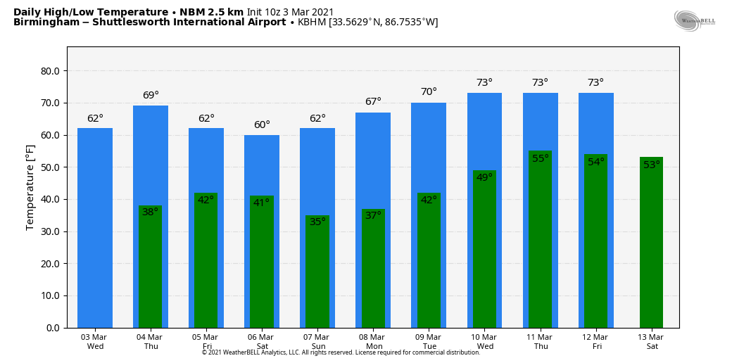
BRIGHTER/WARMER: Lingering clouds across Alabama are moving out quickly early this morning, and today will be brighter and warmer for the state with a good supply of sunshine… temperatures reach the low 60s in most spots this afternoon. The average high for Birmingham on March 3 is 63.
Tomorrow will be a sunny day with a high between 67 and 72… then we will see clouds increasing Friday ahead of a disturbance that might squeeze out a few sprinkles Friday night or early Saturday, mainly over the southern half of the state. Moisture will be very limited, and most places won’t see enough rain to measure, if they get anything at all. The high Friday afternoon will be in the mid to upper 60s.
THE ALABAMA WEEKEND: Clouds Saturday morning will give way to a partly sunny afternoon, and the day will be cooler with a high around 60 degrees. Sunday will feature sunshine in full supply with high in the mid 60s.
NEXT WEEK: The quiet pattern continues… the sky will stay sunny Monday and Tuesday. The high Monday will be in upper 60s… and close to 70 Tuesday. Moisture levels will rise a bit over the latter half of the week, and we might have a day with isolated showers, but an upper ridge will keep of the major rain producing systems north and west of Alabama. Highs will be in the 70s Wednesday through Friday, and we still see no sign of any high impact weather event for the state for the next seven to ten days. See the Weather Xtreme video for maps, graphics, and more details.
ON THIS DATE IN 1966: One of the most devastating tornadoes in Mississippi history occurred. This tornado would come to be known as the “Candlestick Park” tornado, named after a shopping center in south Jackson which was totally destroyed by the tornado. One of only two documented F5 (the most violent on the Fujita scale) tornadoes to strike Mississippi in the 20th century, this tornado carved a path of destruction across central and east central Mississippi. The worst damage occurred in parts of Hinds, Rankin, Scott, and Leake counties, where a total of 57 people were killed and over 500 were injured.
ON THIS DATE IN 2019: A violent EF-4 tornado killed 23 people in Lee County, south of Auburn and Opelika. 97 others were injured, some critically. The tornado was on the ground for 69 miles and reached a peak width of 1,600 yards. This was the first violent (EF4 or EF5) tornado in the United States since April 29, 2017 and the deadliest since the 2013 Moore, Oklahoma tornado. It was also the first violent tornado in Lee County since 1875 and the first deadly tornado to strike Lee County since 1953.
An analysis led by engineer David Roueche (Auburn University) found that 19 of the 23 deaths on March 3, 2019 in Lee County were associated with manufactured homes, as opposed to site-built homes.
BEACH FORECAST: Click here to see the AlabamaWx Beach Forecast Center page.
WEATHER BRAINS: Don’t forget you can listen to our weekly 90 minute show anytime on your favorite podcast app. This is the show all about weather featuring many familiar voices, including our meteorologists here at ABC 33/40.
CONNECT: You can find me on all of the major social networks…
Look for the next Weather Xtreme video here by 3:00 this afternoon… enjoy the day!
Category: Alabama's Weather, ALL POSTS, Weather Xtreme Videos
About the Author (Author Profile)
James Spann is one of the most recognized and trusted television meteorologists in the industry. He holds the AMS CCM designation and television seals from the AMS and NWA. He is a past winner of the Broadcast Meteorologist of the Year from both professional organizations.Subscribe
If you enjoyed this article, subscribe to receive more just like it.


