

We Can’t Forget About the Potential for Strong to Severe Storms on Monday
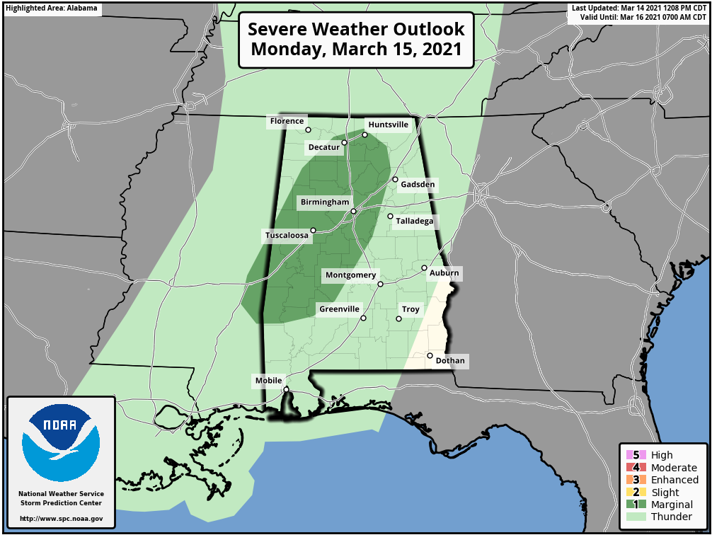
While we are all cued in on what to expect for Wednesday potential for a significant severe weather event, we simply cannot overlook the threat for strong to severe storms on Monday. At this time, the Storm Prediction Center has a good portion of North Central Alabama in a Level 1 Marginal Risk for severe storms mainly from 10 am to 6 pm on Monday. The main threats will be from:
• Isolated damaging wind gusts up to 60 mph
• Hail up to quarter size (1-inch in diameter)
• A brief spin-up tornado
The Marginal Risk includes the cities of Huntsville, Decatur, Guntersville, Haleyville, Cullman, Oneonta, Jasper, Warrior, Pell City, Birmingham, Reform, Tuscaloosa, Alabaster, Aliceville, Eutaw, Marion, York, Demopolis, Selma, and Sweet Water.
Breakdown of what to expect:
• A few showers will move across North/Central Alabama during the late-night hours tonight through the pre-dawn and morning hours on Monday. These will be non-severe and most likely light in nature.
• By the midday hour, a line of showers and thunderstorms will begin to move into the northwestern corner of North/Central Alabama. This is when the threat window opens for stronger to severe storms.
• The line will be in a weakening trend through the early afternoon, but the line looks to intensify a little during the mid to late afternoon hours, mainly over the eastern parts of Lauderdale, Colbert, and Franklin counties, and into Lawrence, Limestone, and western portions of Morgan counties.
• By 6 pm, the threat of severe storms look to be over for the area, bus heavy rain and thunderstorms will continue to be possible for locations east of I-65 and along and north of the Tennessee River. Much of the heavier activity may actually stay north of Tuscaloosa and Birmingham.
• The 00z run of the high-resolution NAM shows that plenty of instability will be available over the Marginal Risk area
• The better shear values needed to make thunderstorms more organized and persistent will be displaced north and east out of the area while the line moves into the area, but enough shear is present for the potential of a brief severe storm or two.
• The same can be said with the helicity values… while values will be just high enough for a rotating updraft or two, the much higher values will be displaced northeast of the line and out of the area.
Just like with any other severe weather threat, be sure you have your safety kits, your safety plans, and several trusty ways to get warnings ready to go just in case your location goes under a warning.
Category: Alabama's Weather, ALL POSTS, Severe Weather
About the Author (Author Profile)
Scott Martin is an operational meteorologist, professional graphic artist, musician, husband, and father. Not only is Scott a member of the National Weather Association, but he is also the Central Alabama Chapter of the NWA president. Scott is also the co-founder of Racecast Weather, which provides forecasts for many racing series across the USA. He also supplies forecasts for the BassMaster Elite Series events including the BassMaster Classic.Subscribe
If you enjoyed this article, subscribe to receive more just like it.


