

Unsettled Weather; Significant Severe Weather Threat Wednesday
ACTIVE WEATHER RETURNS: Birmingham and most of Alabama has experienced 12 consecutive days of dry weather, which is very unusual for March. But it all changes this week as a story pattern sets up for the Deep South.
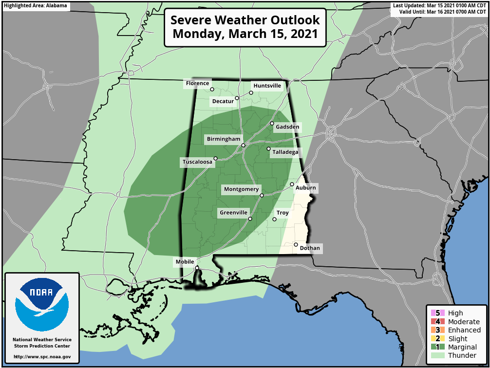
TODAY: An approaching storm system will bring showers and thunderstorms to the state today. We have showers on radar this morning over West Alabama, heavier storms are possible this afternoon. SPC has much of the state in a “marginal risk” (level 1/5) of severe thunderstorms through tonight… some of the storms later today could produce small hail and gusty winds. A brief, isolated tornado is possible, but not likely.
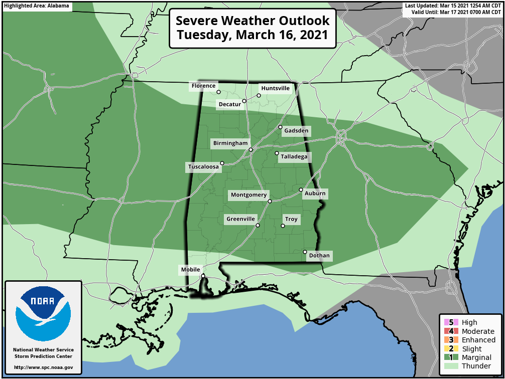
TOMORROW: A surface front will be draped across Central Alabama, and we will maintain the chance of showers and a few thunderstorms during the day. Not an “all day” kind of rain, but a few passing showers are likely. And, like today, SPC has much of the state in a “marginal risk”. Heavier thunderstorms tomorrow afternoon could produce small hail and gusty winds. Tornadoes are very unlikely.
SIGNIFICANT SEVERE WEATHER THREAT WEDNESDAY: While you certainly need to pay attention to the weather over the next 48 hours, the main threat comes late Wednesday afternoon and Wednesday night as a dynamic storm system moves into the state. A negative tilt upper trough with strong wind fields will be established to the west, with an associated deep surface low. Alabama will be in a warm, sheared, unstable airmass by afternoon, setting the stage for severe thunderstorm development.
SPC has much of the state in an “enhanced risk” (level 3/5).
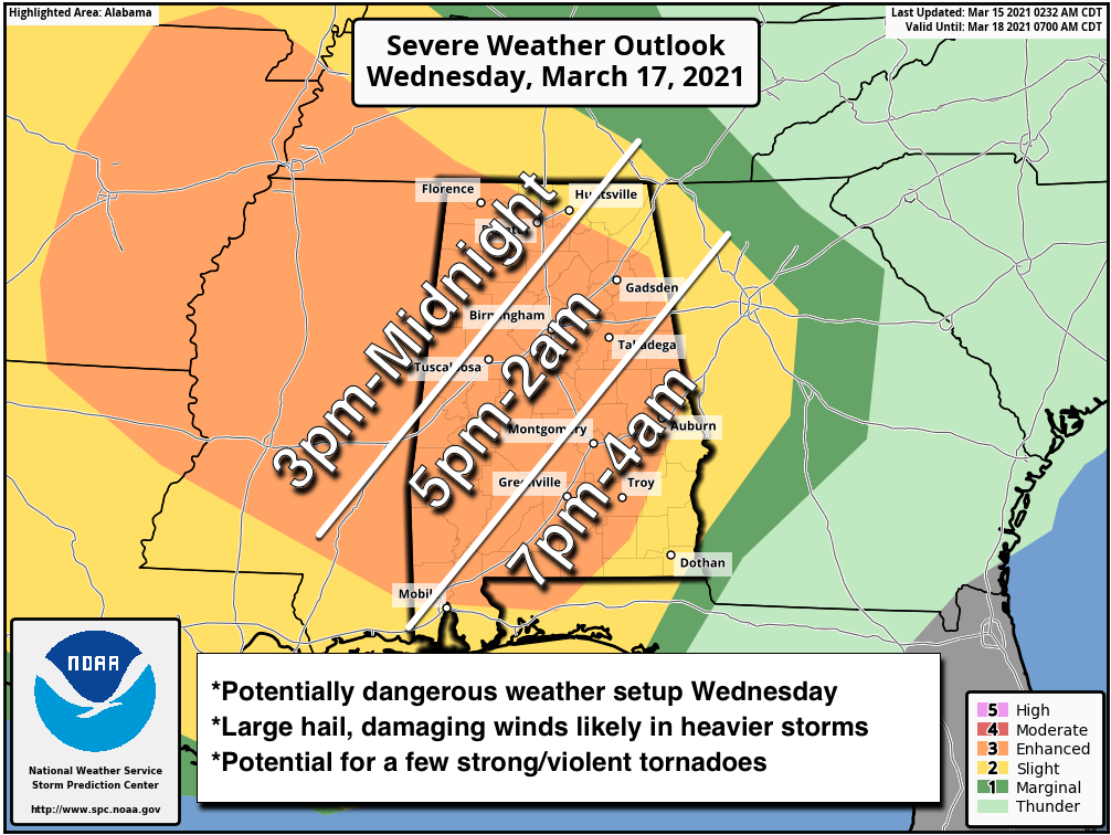
Thunderstorms could begin over West Alabama during the afternoon hours… but for much of the state the core severe weather comes Wednesday evening and Wednesday night… into the pre-dawn hours Thursday.
Storms will have potential to bring large hail, damaging winds, and tornadoes. A few strong/violent tornadoes are possible across the Deep South considering the atmospheric setup.
A few preparedness notes…
*Be sure WEA (Wireless Emergency Alerts) are enabled on your phone. Look under notifications. Tornado warnings, flash flood warnings, and amber alerts are pushed to your phone via WEA, and it doesn’t involve an app.
*We recommend the ABC 33/40 app for your phone also to push alerts. You can select the warnings you receive, and it works well and is very reliable.
*The most popular NOAA Weather radio is the Midland WR-120. You can find it at most big box retailers, and online sellers like Amazon. Every home and business needs a NOAA Weather Radio! NEVER rely on an outdoor warning siren!
*You need helmets for everyone, including adults, in your safe place. Bicycle helmets and batting helmets work very well.
*It is also a good idea for everyone to have hard soled shoes on (in case you have to walk over a debris field), and a portable air horn (in case you need to alert first responders).
*You can’t stay in a mobile home during a tornado. Know now where you will go in case you are under a tornado warning polygon. Community shelter, a business that open 24/7, etc.
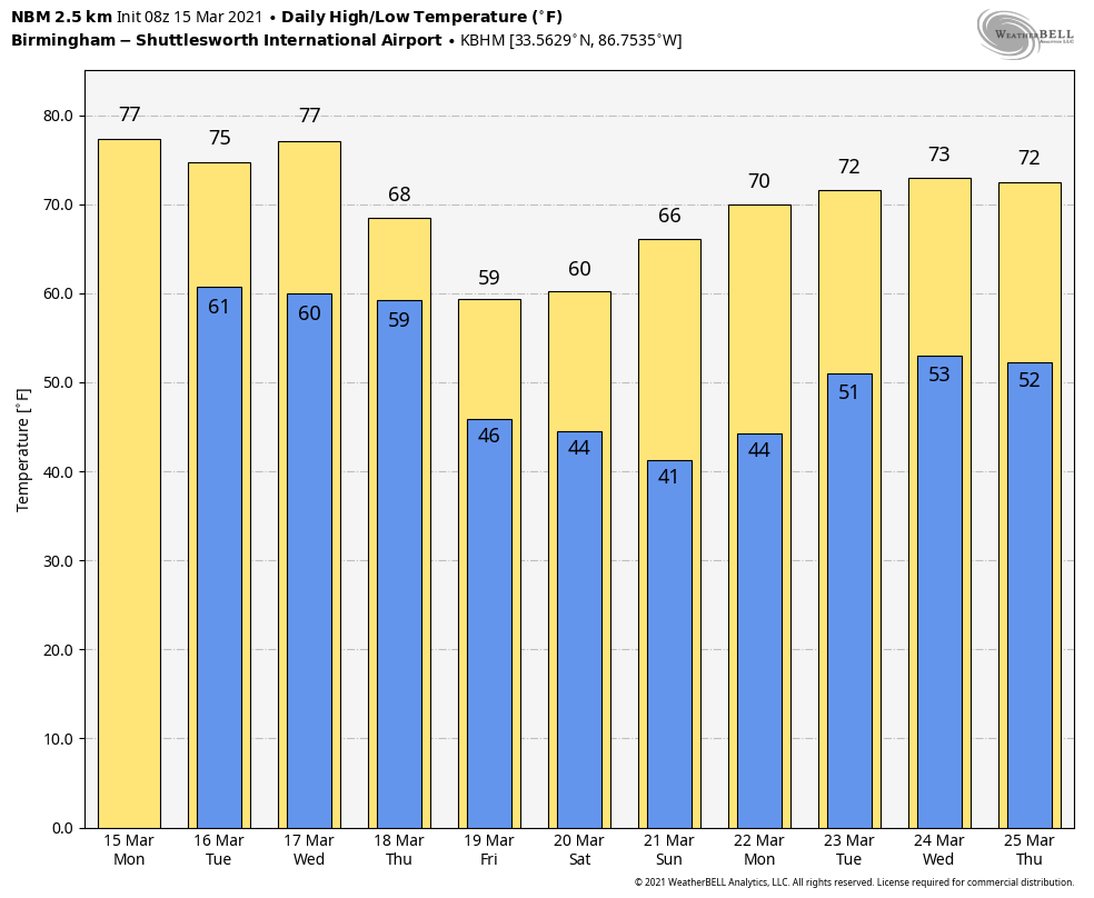
THURSDAY/FRIDAY: Storms end early in the day Thursday, and some clearing is likely by afternoon as drier air begins to arrive. The high Thursday will be in the low 70s, but Friday will be mostly cloudy and cooler with a high between 58 and 63 degrees. A few sprinkles are possible Friday, but most of the state will be dry.
THE ALABAMA WEEKEND: Saturday will be partly sunny and cool with a high in the 55-60 degree range… then expect sunshine in full supply Sunday with a high in the mid 60s.
NEXT WEEK: Dry weather continues Monday and Tuesday… the next system will bring another round of rain and storms by Wednesday or Thursday. See the Weather Xtreme video for maps, graphics, and more details.
ON THIS DATE IN 1952: On Reunion Island, some 400 miles east of Madagascar 127.56 inches of rain fell in three days in the spring of 1952. This set a world record for the most rainfall in 72 hours. Also, from the 15th to the 16th, 73.62 inches of rain fell in the 24 hours at Cilaos, La Reunion Island in the South Indian Ocean to set a world record.
BEACH FORECAST: Click here to see the AlabamaWx Beach Forecast Center page.
WEATHER BRAINS: Don’t forget you can listen to our weekly 90 minute show anytime on your favorite podcast app. This is the show all about weather featuring many familiar voices, including our meteorologists here at ABC 33/40.
CONNECT: You can find me on all of the major social networks…
Look for the next Weather Xtreme video here by 3:00 this afternoon… enjoy the day!
Category: Alabama's Weather, ALL POSTS, Weather Xtreme Videos
About the Author (Author Profile)
James Spann is one of the most recognized and trusted television meteorologists in the industry. He holds the AMS CCM designation and television seals from the AMS and NWA. He is a past winner of the Broadcast Meteorologist of the Year from both professional organizations.Subscribe
If you enjoyed this article, subscribe to receive more just like it.


