

Mesoscale Discussion Just Released Covering Portions of North/Central Alabama
The Storm Prediction Center just released a mesoscale discussion that covers pretty much the areas located in the Marginal Risk for severe storms. The threat for isolated damaging wind gusts and a brief spin-up tornado continues through the next several hours. At this point, a watch is not likely to be issued.
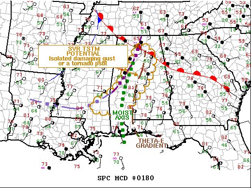
Here is the text from Mesoscale Discussion 0180 released at 2:35 pm:
SUMMARY
Isolated damaging gusts or a tornado may occur this afternoon with thunderstorms in a loosely organized band over AL, and additional convection may build along the associated boundary back into MS. A watch does not appear likely at this time, but conditions will be monitored for any increase in coverage or other more-favorable convective trends that would upgrade the threat.
DISCUSSION
19Z surface mesoanalysis showed a convective/convergence boundary (preceding a decaying, diffuse cold front) in an arc from near HSV-TCL to just north of PIB, with the associated outflow/thermal gradient extending further westward over southern MS. The boundary will move slowly eastward over northern AL, become quasistationary near the state line, and may pivot northward through the remainder of the afternoon across southern MS. This will be the main focus for development, though weakening MLCINH will enable some potential for convection to form in the warm sector to its south as well. An eastern limiting boundary appears in the form of a theta-e gradient (to lower dew points and somewhat lower temperatures) from the western FL Panhandle northward, representing much stronger MLCINH to its east. Slow decay and eastward drift is possible with this boundary.
Modified RAOBs and forecast soundings show MLCAPE in the 1000-2000 J/kg range, amidst 50-60-kt effective-shear magnitudes. Low-level SRH favoring supercell potential is more confined near the TCL-BHM-HSV corridor where hodographs are enlarged near and south of the junction of those boundaries with a warm front, near HSV. This is sampled by the VWP from BMX, with 0-3-km SRH of 300-400 J/kg.
Convection should continue to deepen across this corridor, as diurnal destabilization continues to both:
1. Increase low-level lapse rates/boundary-layer buoyancy and
2. Overcome a midlevel stable layer sampled by the 12Z JAN RAOB.
The main limiting factors appear to be lack of both upper support and stronger low-level lift.
Category: Alabama's Weather, ALL POSTS, Severe Weather
About the Author (Author Profile)
Scott Martin is an operational meteorologist, professional graphic artist, musician, husband, and father. Not only is Scott a member of the National Weather Association, but he is also the Central Alabama Chapter of the NWA president. Scott is also the co-founder of Racecast Weather, which provides forecasts for many racing series across the USA. He also supplies forecasts for the BassMaster Elite Series events including the BassMaster Classic.Subscribe
If you enjoyed this article, subscribe to receive more just like it.


