

Cooler, Calmer Weather For Alabama Today
RADAR CHECK: Showers and thunderstorms continue early this morning over far East and Southeast Alabama; a few severe storms were over the southeast corner of the state. A tornado warning was in effect for parts of Dale, Houston, and Henry counties just before daybreak.
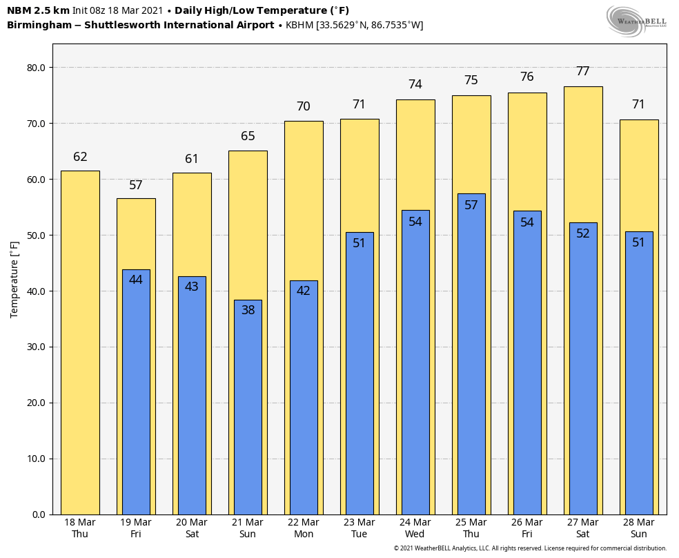
Most of the rain will be into Georgia by 9:00 a.m. Clouds will linger across the state today as an upper trough swings through, and it could squeeze out a few scattered showers over the northern third of the state this afternoon. The day will be cooler with a high in the mid 60s for most communities… the average high for Birmingham on March 18 is 67.
We should also note today will be windy… expects a west wind of 12-22 mph, with higher gusts possible. A wind advisory is in effect for much of Central Alabama.
Tonight and tomorrow will be mostly cloudy and cool; the high tomorrow afternoon will be in the 55-60 degree range over the northern half of the state. There might be a touch of light rain near the Georgia border in spots, but most of Alabama will be dry.
THE ALABAMA WEEKEND: The sky becomes partly to mostly sunny Saturday with a high around 60 degrees. Sunday morning will be clear and cold with lows in the mid to upper 30s… some frost is likely over the northern half of the state, and colder valleys might see a light freeze. Then, during the day Sunday, expect a sunny sky with a high in the mid 60s.
NEXT WEEK: Monday will feature a partly sunny sky with a high in the upper 60s. Clouds return Tuesday along with a chance of showers and thunderstorms. For now the severe weather potential with this system looks low, but a strong storm is very possible. The surface front hangs up, and showers will remain possible Wednesday. Then, another upper air wave will bring a chance of more strong thunderstorms to the state either Thursday or Friday… See the Weather Xtreme video for maps, graphics, and more details.
ON THIS DATE IN 1925: The great “Tri-State Tornado” occurred, the deadliest tornado in U.S. history. The storm claimed 695 lives (including 234 at Murphysboro, IL, and 148 at West Frankfort, IL), and caused seventeen million dollars property damage. It cut a swath of destruction 219 miles long and as much as a mile wide from east-central Missouri to southern Indiana between 1 PM and 4 PM. The tornado leveled a school in West Frankfort, Illinois, and picked up sixteen students setting them down unharmed 150 yards away. Seven other tornadoes claimed an additional 97 lives that day.
ON THIS DATE IN 2013: An EF-1 tornado touched down in Marshall County in Boaz and moved eastward into Etowah County, moving through Sardis City. The most extensive damage occurred as the tornado approached Rowen Road. A mobile home was lifted and overturned leaving one person seriously injured and two others with minor injuries. In this same area, two additional mobile homes were destroyed.
BEACH FORECAST: Click here to see the AlabamaWx Beach Forecast Center page.
WEATHER BRAINS: Don’t forget you can listen to our weekly 90 minute show anytime on your favorite podcast app. This is the show all about weather featuring many familiar voices, including our meteorologists here at ABC 33/40.
CONNECT: You can find me on all of the major social networks…
Look for the next Weather Xtreme video here by 3:00 this afternoon… enjoy the day!
Category: Alabama's Weather, ALL POSTS, Weather Xtreme Videos
About the Author (Author Profile)
James Spann is one of the most recognized and trusted television meteorologists in the industry. He holds the AMS CCM designation and television seals from the AMS and NWA. He is a past winner of the Broadcast Meteorologist of the Year from both professional organizations.Subscribe
If you enjoyed this article, subscribe to receive more just like it.


