

A Quick Look At Our Significant Severe Weather Threat Just Before 10:00 pm
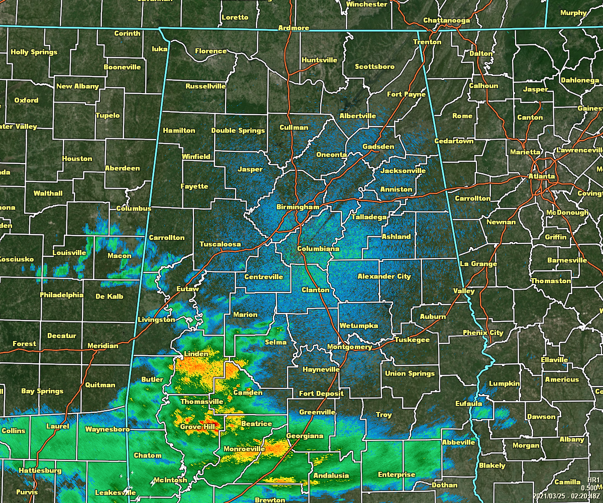
As we approach 9:30 on this Wednesday night, we see that the shield of rain and thunderstorms associated with a slowly moving warm front have started to move back northward over the extreme southwestern parts of Central Alabama and over South Alabama. This activity as it continues to enter Central Alabama will start the rise of instability during the overnight hours that will bring a chance of strong to severe storms to much of the area later in the morning.
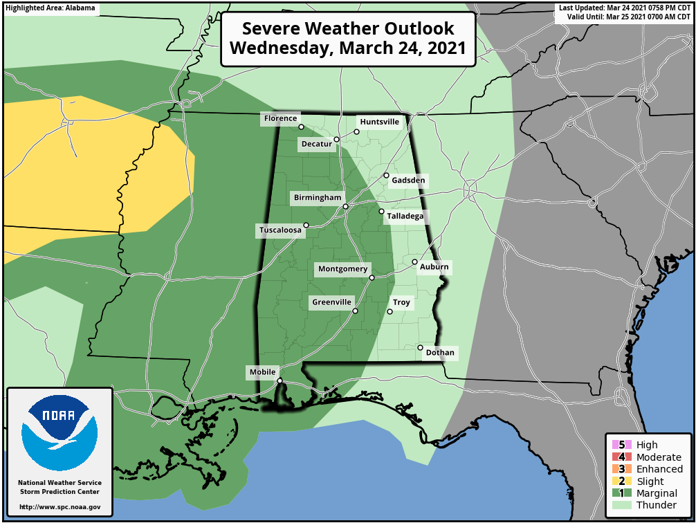
The Storm Prediction Center has introduced a Level 1 Marginal Risk for severe storms on their Day One Severe Weather Outlook for a good portion of North/Central Alabama which goes from now until 7:00 am Thursday morning for the potential of isolated damaging wind gusts, quarter size hail, and a brief spin-up tornado during the pre-dawn hours up to sunrise on Thursday morning. This includes the cities of Florence, Russellville, Hartselle, and Cullman in North Alabama, and for Hamilton, Jasper, Birmingham, Hoover, Talladega, Tuscaloosa, Clanton, Alexander City, Demopolis, Selma, and Montgomery.
The atmosphere will continue to become more unstable after the front passes, so this risk of severe storms will continue until noon. Once we get to midday, that is when we really need to start watching for developing storms over the western half of the area.
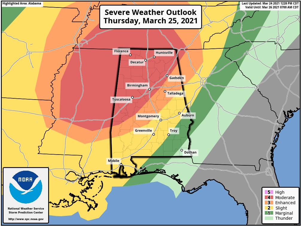
The SPC has a Level 4 Moderate Risk for severe storm up for locations along and west of the I-59 corridor, which includes the cities of Florence, Russellville, Decatur, Athens, Hartselle, Cullman, Huntsville, Guntersville, Scottsboro, and Rainsville in North Alabama, and Hamilton, Tuscaloosa, Demopolis, Birmingham, and Gadsden.
A Level 3 Enhanced Risk for severe storms is up for locations east of the Moderate Risk, which includes the cities of Anniston, Talladega, Clanton, and Selma. A Level 2 Slight Risk is up east of that, which includes Alexander City, Auburn, Troy, and Montgomery. A Level 1 Marginal Risk is up for the extreme southeastern parts of the area, including Eufaula.
Strong tornadoes, damaging winds up to and exceeding 70 mph, and golf ball size hail will be possible for those in the Moderate Risk area. The Enhanced and Slight Risk areas will have the potential for tornadoes, damaging winds up to 60 mph, and quarter size hail, with a strong tornado possible in the Enhanced Risk. The Marginal Risk area will have a minimal threat of isolated damaging winds up to 60 MPH and a brief tornado or two.
The main window for strong to severe storms across the Moderate and Enhanced Risk area will be from 12 pm to 10 pm from west to east, and from 6 pm to midnight west to east for the Slight and Marginal Risk areas. The activity will start off as the potential for discrete supercell thunderstorms that may produce tornadoes, some of which could be of the strong long-track variety, over the Moderate and Enhanced risk areas, but those will eventually dissipate, and we’ll become focused on the main squall line which will move in later and sweep across the entire area.
All ingredients needed for severe storms and for rotating storms will be present and the potential for all modes of severe weather continue to be on the board. I believe the worst of the weather will occur over the northwestern quarter of North/Central Alabama, especially north and west of I-59. But do not let the colors on the map lead you into a false sense of security, as the threat for severe storms exist for all of the area.
With that being said, there is the potential that portions of the northwestern part of North/Central Alabama may be upgraded to a Level 5 High Risk. We will know a little after midnight tonight.
You still have a few hours to get your planning, gathering of your supplies, and readying of your safe place completed. Be sure that those safe places have helmets and hard-toed shoes for each person, and a few loud noise-makers (bullhorn or small air horns) to get someone’s attention just in the event if you become trapped. Also, be sure to know where your county is located on a map of Alabama, and become familiar with the counties that surround where you are. That way, when you here or see that a county close by goes under a warning, you will have that much more notification in advance if a warning is issued for your location down the road.
Have multiple ways to receive warnings (WEAs, NOAA Weather Radio, a trusty weather app that alert you when your location goes under a watch or warning, or battery-operated radios/TVs). If you need any reminders of tornado and severe weather safety measure, please visit the Severe Weather Awareness page on the NWS Mobile website.
If you take the proper steps to keep you and your family/friends/co-workers safe if you go under a warning, we will be able to get through this together.
Category: Alabama's Weather, ALL POSTS, Severe Weather
About the Author (Author Profile)
Scott Martin is an operational meteorologist, professional graphic artist, musician, husband, and father. Not only is Scott a member of the National Weather Association, but he is also the Central Alabama Chapter of the NWA president. Scott is also the co-founder of Racecast Weather, which provides forecasts for many racing series across the USA. He also supplies forecasts for the BassMaster Elite Series events including the BassMaster Classic.Subscribe
If you enjoyed this article, subscribe to receive more just like it.


