

Portions of North/Central Alabama Upgraded to High Risk; Wind Advisory In Effect for Much of the Area
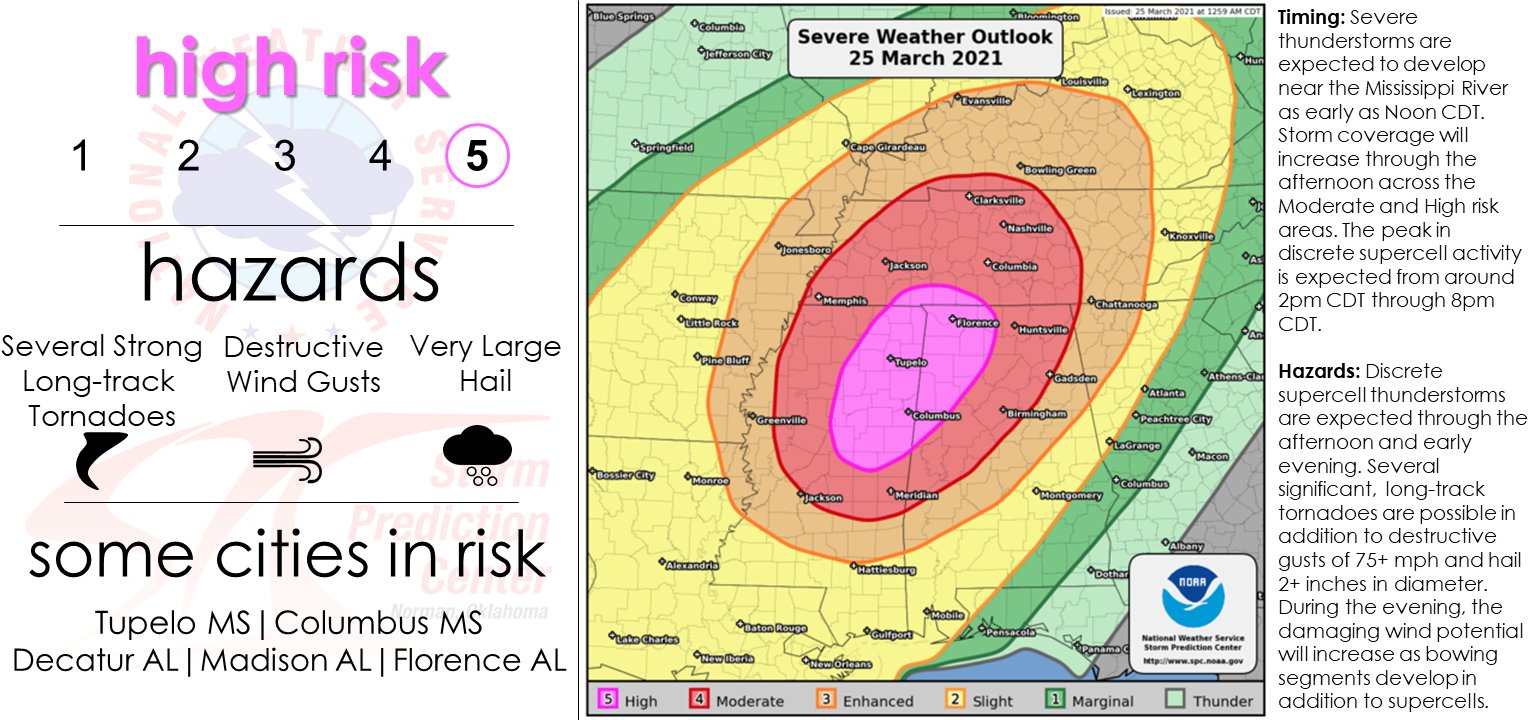
SPC has upgraded the northwestern parts of North/Central Alabama to the rare Level 5 High Risk for severe storms throughout the day today, which includes the cities of Florence, Russellville, Athens, Decatur, and Hartselle in North Alabama, and Hamilton, Double Springs, Winfield, Fayette, and Carrollton in Central Alabama.
East of the high risk area, a Level 4 Moderate Risk is up that includes the cities of Huntsville, Cullman, Guntersville, Scottsboro, and Rainsville in North Alabama, and for Gadsden, Birmingham, Hoover, Tuscaloosa, and Demopolis in Central Alabama.
East of the moderate risk area, a Level 3 Enhanced Risk is up that includes the cities of Anniston, Talladega, Alexander City, Clanton, and Selma.
East of the enhanced risk area, a Level 2 Slight Risk is up that includes the cities of Auburn, Montgomery, and Troy.
A Level 1 Marginal Risk is up for the extreme southeastern parts of the area that includes the cities of Phenix City and Eufaula.
Timing for the threat of severe storms will be from 11 am to 11 pm today for the high and moderate risk areas, and from 6 pm this evening to 12 am Friday for the rest of the area.
Tornadoes, damaging winds, and large hail will be possible all across North/Central Alabama, with the potential of strong to violent tornadoes and golf ball size hail occurring in the high and moderate risk areas.
These storms will be moving very quickly, so if your location goes under a warning, get to your place of safety immediately.
CURRENT WATCHES AND ADVISORIES
Flash Flood Watch continues until 1 am Friday morning for the following counties in North Alabama: Colbert, Cullman, DeKalb, Franklin, Jackson, Lauderdale, Lawrence, Limestone, Madison, Marshall, and Morgan.
Wind Advisory continues until 1 am Friday morning for the following counties in North Alabama: Colbert, Cullman, DeKalb, Franklin, Jackson, Lauderdale, Lawrence, Limestone, Madison, Marshall, and Morgan.
Wind Advisory continues until 1 am Friday morning for the following counties in Central Alabama: Autauga, Bibb, Blount, Calhoun, Chambers, Cherokee, Chilton, Clay, Cleburne, Coosa, Dallas, Elmore, Etowah, Fayette, Greene, Hale, Jefferson, Lamar, Lowndes, Marengo, Marion, Montgomery, Perry, Pickens, Randolph, Shelby, St. Clair, Sumter, Talladega, Tallapoosa, Tuscaloosa, Walker, and Winston.
Category: Alabama's Weather, ALL POSTS, Severe Weather
About the Author (Author Profile)
Scott Martin is an operational meteorologist, professional graphic artist, musician, husband, and father. Not only is Scott a member of the National Weather Association, but he is also the Central Alabama Chapter of the NWA president. Scott is also the co-founder of Racecast Weather, which provides forecasts for many racing series across the USA. He also supplies forecasts for the BassMaster Elite Series events including the BassMaster Classic.Subscribe
If you enjoyed this article, subscribe to receive more just like it.


