

Midday Nowcast: Some Sun and Some Clouds
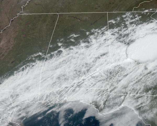
Better weather today as we are seeing sunshine across north Alabama with more clouds down to the south, highs in the mid to upper 70s, and calm weather that is a welcomed sight as people clean up after yesterday’s storms. A few scattered showers continue across South Alabama along the cold front. Overnight, the front will lift back north as a warm front, and could bring showers and a few thunderstorms to the state overnight. Lows will be in the upper 60s.
WEEKEND WEATHER: Tomorrow will be a very warm and breezy day with a few scattered showers, but most of us should remain dry with highs will be in the upper 70s and low 80s. Also tomorrow, more severe storms are expected across the Tennessee River Valley along the aforementioned warm front and the SPC has a severe weather risk in place for portions of Arkansas, Tennessee, Mississippi and Northwest Alabama.
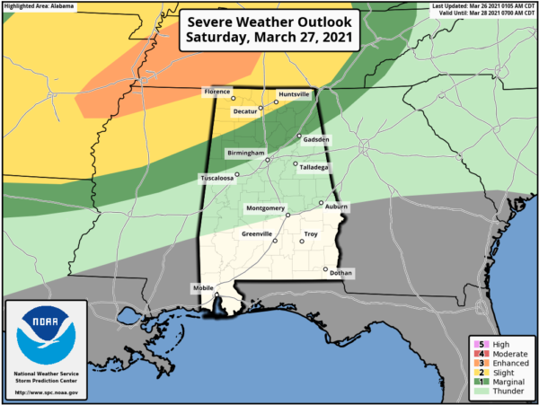
A few storms could produce hail and strong gusty winds, and perhaps an isolated tornado during the afternoon and evening hours up near the Memphis and Nashville areas. For Sunday, the front pushes back to the south as a cold front and will bring showers and storms back to Alabama. A few storms could be severe and the SPC has much of the state in a “marginal risk” (level 1/5) for severe storms Sunday. This would be for the morning hours and early into the afternoon as the front pushes south.
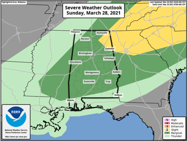
The main threats for now on Sunday would come from damaging winds and hail. For now, tornadoes are not expected due to the forecast wind fields. Rain amounts over the weekend will be around one inch for most places…the ground is saturated, and a few isolated flooding issues can’t be totally ruled out. Sunday’s high will be in the low 70s.
BEACH FORECAST CENTER: Get the latest weather and rip current forecasts for the beaches from Fort Morgan to Panama City on our Beach Forecast Center page. There, you can select the forecast of the region that you are interested in visiting.
WORLD TEMPERATURE EXTREMES: Over the last 24 hours, the highest observation outside the U.S. was 110.5F at Kendougou, Senegal. The lowest observation was -74.2F at Vostok, Antarctica.
CONTIGUOUS TEMPERATURE EXTREMES: Over the last 24 hours, the highest observation was 94F at Dundee, FL. The lowest observation was -2F at Gould, CO.
Category: Alabama's Weather, ALL POSTS
About the Author (Author Profile)
Macon, Georgia Television Chief Meteorologist, Birmingham native, and long time Contributor on AlabamaWX. Stormchaser. I did not choose Weather, it chose Me. College Football Fanatic. @Ryan_StinnetSubscribe
If you enjoyed this article, subscribe to receive more just like it.


