

Strong Storms Affecting Walker & Jefferson Counties
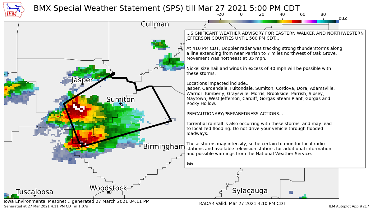
…SIGNIFICANT WEATHER ADVISORY FOR EASTERN WALKER AND NORTHWESTERN
JEFFERSON COUNTIES UNTIL 500 PM CDT…
At 410 PM CDT, Doppler radar was tracking strong thunderstorms along
a line extending from near Parrish to 7 miles northwest of Oak Grove.
Movement was northeast at 35 mph.
Nickel size hail and winds in excess of 40 mph will be possible with
these storms.
Locations impacted include…
Jasper, Gardendale, Fultondale, Sumiton, Cordova, Dora, Adamsville,
Warrior, Kimberly, Graysville, Morris, Brookside, Parrish, Sipsey,
Maytown, West Jefferson, Cardiff, Gorgas Steam Plant, Gorgas and
Rocky Hollow.
PRECAUTIONARY/PREPAREDNESS ACTIONS…
Torrential rainfall is also occurring with these storms, and may lead
to localized flooding. Do not drive your vehicle through flooded
roadways.
These storms may intensify, so be certain to monitor local radio
stations and available television stations for additional information
and possible warnings from the National Weather Service.
Category: Alabama's Weather, ALL POSTS, Severe Weather
About the Author (Author Profile)
Scott Martin is an operational meteorologist, professional graphic artist, musician, husband, and father. Not only is Scott a member of the National Weather Association, but he is also the Central Alabama Chapter of the NWA president. Scott is also the co-founder of Racecast Weather, which provides forecasts for many racing series across the USA. He also supplies forecasts for the BassMaster Elite Series events including the BassMaster Classic.Subscribe
If you enjoyed this article, subscribe to receive more just like it.


