

Flash Flood Watch Issued for Portions of Central Alabama from This Evening Until Wednesday Evening
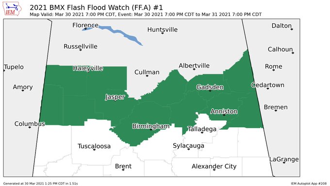
NWS Birmingham has issued a Flash Flood Watch starting at 7 pm this evening and set to expire at 7 pm Wednesday evening for the following counties in Central Alabama: Blount, Calhoun, Cherokee, Cleburne, Etowah, Fayette, Jefferson, Lamar, Marion, St. Clair, Walker, and Winston.
…FLASH FLOOD WATCH IN EFFECT FROM 7 PM CDT THIS EVENING THROUGH WEDNESDAY EVENING…
The National Weather Service in Birmingham has issued a
* Flash Flood Watch for portions of central Alabama…east central Alabama…northeast Alabama…northwest Alabama and west central Alabama, including the following areas, in central Alabama, Blount, Jefferson, St. Clair and Walker. In east central Alabama, Calhoun and Cleburne. In northeast Alabama, Cherokee and Etowah. In northwest Alabama, Marion and Winston. In west central Alabama, Fayette and Lamar.
* From 7 PM CDT this evening through Wednesday evening
* Rainfall amounts from one to two inches are expected within the watch area.
PRECAUTIONARY/PREPAREDNESS ACTIONS…
A Flash Flood Watch means that conditions may develop that lead to Flash Flooding. Flash Flooding is a very dangerous situation. You should monitor later forecasts and be prepared to take action should Flash Flood Warnings be issued.
Category: Alabama's Weather, ALL POSTS, Severe Weather
About the Author (Author Profile)
Scott Martin is an operational meteorologist, professional graphic artist, musician, husband, and father. Not only is Scott a member of the National Weather Association, but he is also the Central Alabama Chapter of the NWA president. Scott is also the co-founder of Racecast Weather, which provides forecasts for many racing series across the USA. He also supplies forecasts for the BassMaster Elite Series events including the BassMaster Classic.Subscribe
If you enjoyed this article, subscribe to receive more just like it.


