

Flash Flood Warning for Parts of Walker, Marion, Winston, Fayette, and Lamar Counties; Flash Flood Watches Continue for the Northern Third of the State
UPDATE AT 6:44 AM
The NWS in Birmingham has extended the warning to go until 8:45 a.m. now.
UPDATE 6:38 AM
Flooding is being reported in parts of Guin in Marion County with 6 inches of flowing water being reported in spots.
ORIGINAL POST 4:38 AM
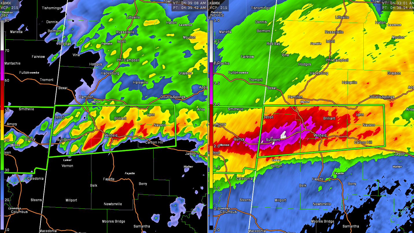
6-8 inches of rain has fallen across parts of northern Lamar and Marion Counties in Northwest Alabama. Flooding is either occurring or is imminent in the Flash Flood Warning area.
The National Weather Service in Birmingham has issued a
* Flash Flood Warning for…
Northwestern Walker County in central Alabama…
Southern Marion County in northwestern Alabama…
Southwestern Winston County in northwestern Alabama…
Northwestern Fayette County in west central Alabama…
Northern Lamar County in west central Alabama…
* Until 745 AM CDT.
* At 438 AM CDT, Doppler radar indicated thunderstorms producing
heavy rain across the warned area. Between 2 and 4 inches of rain
have fallen. Flash flooding is ongoing or expected to begin
shortly.
HAZARD…Flash flooding caused by thunderstorms.
SOURCE…Doppler radar.
IMPACT…Flooding of small creeks and streams, urban areas,
highways, streets and underpasses as well as other
drainage and low lying areas.
* Some locations that will experience flash flooding include…
Winfield, Carbon Hill, Sulligent, Lynn, Guin, Brilliant, Glen
Allen, Detroit, Kansas, Nauvoo, Beaverton, Gu-Win, Eldridge,
Crews, Lamar County Airport, Ashbank, Poplar Springs, Twin,
Natural Bridge and Tucker.
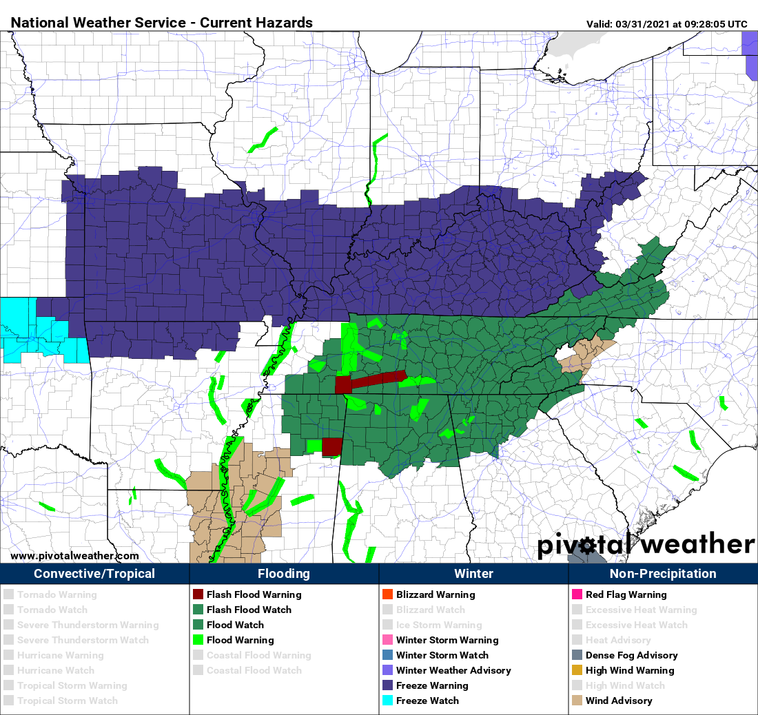
In addition, Flash Flood Watches are in effect for much of North and Central Alabama. The NWS Huntsville continues its Flash Flood Watch for Colbert, Cullman, DeKalb, Franklin, Jackson, Lauderdale, Lawrence, Limestone, Madison, Marshall, and Morgan Counties in Alabama till 7:00 PM CDT.
The NWS in Birmingham continues its Flash Flood Watch until 7 p.m. for Blount, Calhoun, Cherokee, Cleburne, Etowah, Fayette, Jefferson, Lamar, Marion, St. Clair, Walker, and Winston Counties.
Those counties in dark blue to the north of us are under Freeze Warnings. We will be going under Freeze Warnings as well later today. While we may escape freezing conditions tonight, some frost is possible in colder locations, and a freeze is likely Friday and Saturday mornings areawide. Temperatures will drop rapidly behind a cold front that will be moving across the area starting late this morning. The front should reach Muscle Shoals by 8 a.m. and Birmingham by 1 p.m. Temperatures will fall around 10 degrees in the first few hours behind the frontal passage and will be in the 40s by mid-afternoon over Northwest Alabama. We will be in the 40s by 7 p.m. in the I=59 Corridor and lows by morning will range from 31-36F areawide by morning.
Category: Alabama's Weather, ALL POSTS, Severe Weather
About the Author (Author Profile)
Bill Murray is the President of The Weather Factory. He is the site's official weather historian and a weekend forecaster. He also anchors the site's severe weather coverage. Bill Murray is the proud holder of National Weather Association Digital Seal #0001 @wxhistorianSubscribe
If you enjoyed this article, subscribe to receive more just like it.


