Numerous flash flood warnings continue this morning from the Houston and Amory area in northeastern Mississippi across Lamar, Marion, Fayette, Walker, Winston, Cullman, and Blount Counties. Flooding is a significant concern.
Flooding is being reported in Guin in Marion County, where reports indicate that a section of 15th Avenue has washed away. Creeks passing under Highway 43 continue to rise and could cause the road to become impassable. The good news is that rain is decreasing upstream of Marion County which is now behind the front.
Our Skywatcher is Arley is reporting 4.4 inches of rain since midnight.
A line of storms extends from Marshall County through eastern Cullman, northern Jefferson, northern Tuscaloosa, and Pickens Counties. The airmass ahead of the storms will become increasingly unstable as we go through the late morning and into the afternoon and severe storms will become possible. Wind damage and hail will be the main threats.
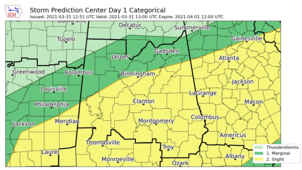
The new SPC outlook is out:
The slight risk continues for areas along and south of I-20. The threat has diminished for locations that are behind the cold front, with a narrow area of marginal risk to the north of I-20 where some damaging winds could occur before the front passes.


