

Midday Nowcast: Splendid Spring Weather
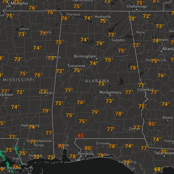
It is another splendid spring day of weather across the great state of Alabama with ample sunshine, and warm, pleasant temperatures that are surging into the upper 70s and lower 80s this afternoon. Tonight will be a clear and cool with lows in the low and mid 50s.
WARM WEDNESDAY: Tomorrow will be another nice, spring day as temperatures again climb to around the 80 degree mark by the afternoon. Tomorrow, moisture levels begin to rise and clouds begin to increase by the afternoon. The day will be dry, but an approaching cold front will bring a band of rain and thunderstorms to the state tomorrow night and into Thursday.
RAIN/STORMS RETURN: The SPC has defined a “slight risk” (level 2/5) for a few counties near the Mississippi border, and a “marginal risk” (level 1/5) as far east as Scottsboro, Clanton, and Grove Hill.
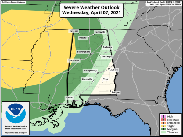
The storms will be weakening as they enter West Alabama, but they could still produce strong, gusty winds and some hail. Tornado chances are very low, but not zero, so we will need to mention the low chance of a brief, isolated tornado. The main window for the storms to roll through the state will come from 9PM Wednesday night through 9AM Thursday morning, but again, the storms will be weakening as the main dynamics pull well north of Alabama.
Storms will end early Thursday morning as a dry slot moves into the state, and a decent part of the day Thursday looks dry with some sun possible and a high in the upper 70s across the northern half of the state, while shower and storms will remain possible across South Alabama.
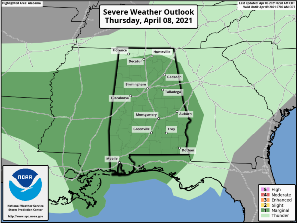
Thursday night, another round of rain and storms are expected to move into the state, again, they could be fairly heavy with strong winds and some hail possible and the SPC has much of the state in a “marginal risk” (level 1/5) for this reason Thursday and Thursday night.
BEACH FORECAST CENTER: Get the latest weather and rip current forecasts for the beaches from Fort Morgan to Panama City on our Beach Forecast Center page. There, you can select the forecast of the region that you are interested in visiting.
WORLD TEMPERATURE EXTREMES: Over the last 24 hours, the highest observation outside the U.S. was 115.2F at Matam, Senegal. The lowest observation was -87.5F at University Dome, Antarctica.
CONTIGUOUS TEMPERATURE EXTREMES: Over the last 24 hours, the highest observation was 101F at Topock, AZ. The lowest observation was 11F Peter Sinks, UT.
WEATHER ON THIS DATE IN 1989: Unseasonably hot weather prevailed in California. Afternoon highs of 91 degrees in Downtown San Francisco, 93 degrees at San Jose, 98 degrees at San Diego, 103 degrees at Santa Maria, 104 degrees at Riverside, and 106 degrees in Downtown Los Angeles established records for the month of April.
Category: Alabama's Weather, ALL POSTS
About the Author (Author Profile)
Macon, Georgia Television Chief Meteorologist, Birmingham native, and long time Contributor on AlabamaWX. Stormchaser. I did not choose Weather, it chose Me. College Football Fanatic. @Ryan_StinnetSubscribe
If you enjoyed this article, subscribe to receive more just like it.


