

Scattered Strong Storms This Afternoon; Severe Storms Late Tonight/Early Tomorrow
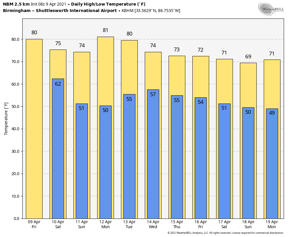
MORE ACTIVE WEATHER AHEAD: We have a few scattered showers and storms over the southern half of Alabama early this morning, but North Alabama is dry just before sunrise. Scattered showers and thunderstorms will develop statewide later today as the air becomes very unstable. It won’t rain everywhere, but where storms do form they will be capable of producing some hail and strong gusty winds. Otherwise, expect a mix of sun and clouds today with a high around 80 degrees.
SEVERE STORMS LIKELY LATE TONIGHT/EARLY TOMORROW: A dynamic weather system will bring multiple waves of thunderstorms to Alabama after midnight tonight into tomorrow morning. SPC has defined an “enhanced risk” of severe thunderstorms (level 3/5) for areas west of a line from Birmingham to Evergreen to Mobile, with a “slight risk” (level 2/5) for the rest of the state. Keep in mind the “Day 1” outlook is valid through 7:00 a.m. CT tomorrow.
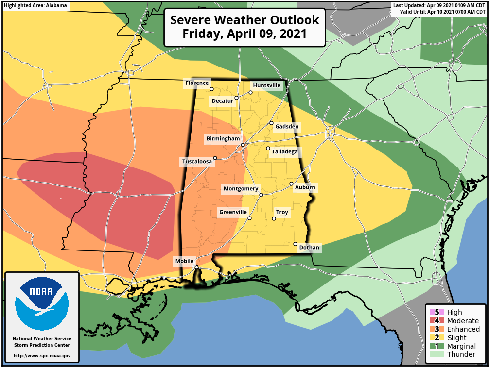
TIMING: The main threat of severe thunderstorms for North/Central Alabama is from midnight tonight through 10:00 tomorrow morning. A few storms could linger over the southeast corner of the state through noon.
THREATS: The main concern is the potential for damaging straight line winds with the lines and clusters of storms that pass through. Some hail is also possible, and a tornado or two can’t be ruled out, especially south of I-20.
RAIN: Rain amounts of 1-2 inches are likely overnight, with isolated amounts to 3 inches. Some flooding issues could develop in scattered spots.
It is important to pay attention to severe thunderstorm warnings that are issued overnight since the main threat is from straight line winds. The sky becomes partly to mostly sunny late tomorrow morning and through the afternoon as a dry slot moves into the state… the high will be in the mid 70s.
SUNDAY AND NEXT WEEK: The weather will be dry Sunday through Tuesday with mostly sunny days and fair nights… the high Sunday will be in the mid 70s, and close to 80 Monday and Tuesday. A few showers and storms are likely Wednesday, followed by dry weather Thursday and Friday. See the Weather Xtreme video for maps, graphics, and more details.
ON THIS DATE IN 1947: An estimated F5 tornado struck Woodward, Oklahoma during the late evening killing 95 persons and causing six million dollars damage. The tornado, one to two miles in width, and traveling at a speed of 50 mph, killed a total of 167 persons along its 221-mile path from Texas into Kansas, injured 980 others, and caused nearly ten million dollars damage.
BEACH FORECAST: Click here to see the AlabamaWx Beach Forecast Center page.
WEATHER BRAINS: Don’t forget you can listen to our weekly 90 minute show anytime on your favorite podcast app. This is the show all about weather featuring many familiar voices, including our meteorologists here at ABC 33/40.
CONNECT: You can find me on all of the major social networks…
Look for the next Weather Xtreme video here by 3:00 this afternoon… enjoy the day!
Category: Alabama's Weather, ALL POSTS, Weather Xtreme Videos
About the Author (Author Profile)
James Spann is one of the most recognized and trusted television meteorologists in the industry. He holds the AMS CCM designation and television seals from the AMS and NWA. He is a past winner of the Broadcast Meteorologist of the Year from both professional organizations.Subscribe
If you enjoyed this article, subscribe to receive more just like it.


