

An Early Afternoon Forecast Update
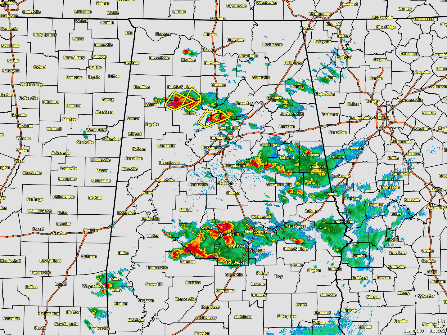
As of 1:42 pm, scattered showers and thunderstorms are dotting the radar across a good portion of North/Central Alabama, with a few of those storms with the potential for large hail. Severe Thunderstorm Warnings are in effect for those cells over Walker and Winston counties, along with cells over Blount and Jefferson counties.
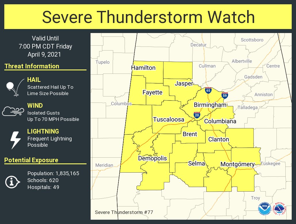
SEVERE THUNDERSTORM WATCH UNTIL 7 PM THIS EVENING
The Storm Prediction Center & NWS Birmingham has issued a Severe Thunderstorm Watch for the following counties in Central Alabama until 7 pm this evening: Autauga, Bibb, Chilton, Coosa, Dallas, Elmore, Fayette, Greene, Hale, Jefferson, Lamar, Lowndes, Marengo, Marion, Montgomery, Perry, Pickens, Shelby, Sumter, Tuscaloosa, Walker, and Winston.
Scattered thunderstorm development is expected through the afternoon across west central into central Alabama. The strongest storms could develop some supercell structures and pose a threat for large hail and isolated damaging winds, prior to weakening this evening.

POTENTIAL FOR STRONG/SEVERE STORMS LATE TONIGHT THROUGH LATE MORNING ON SATURDAY
Much of Central Alabama continues under a level 3/5 Enhanced Risk for severe storms through the rest of your Friday and until 7 am Saturday, which includes Russellville, Hamilton, Birmingham, Hoover, Tuscaloosa, Clanton, Demopolis, Selma, and Montgomery. A Slight Risk covers nearly the rest of North/Central Alabama including Florence, Decatur, Athens, Hartselle, Cullman, Huntsville, Guntersville, Scottsboro, Rainsville in North Alabama, and Gadsden, Anniston, Talladega, Alexander City, Auburn, Eufaula, and Troy in Central Alabama. The western portions of Pickens, Greene, and much of Sumter County have been included in a level 4/5 Moderate Risk.
The timing for severe weather throughout this first long round will continue from now through at least through 1 am Saturday morning before the second round begins to enter the western parts of the area at or just after 3 am. The Day 1 Severe Weather Outlook continues through 7 am Saturday morning. This first round will consist of mainly scattered storms forming along and behind the warm front as the air quickly destabilizes. Not everyone will see rain with this first round, but rain chances are in the 40-70% range from north to south.
That second round of storms with the potential for severe weather will continue through much of the morning from west to east until the stronger part of the line exits the area by 10 am Saturday.
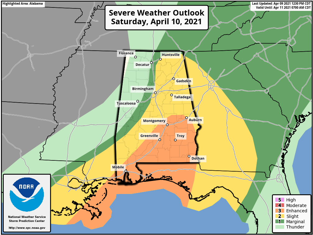
Most of the southern and southeastern parts of Central Alabama have been upgraded to an Enhanced Risk for severe storms on Saturday, which includes Montgomery, Auburn, Troy, and Eufaula. The rest of the south and southeastern parts, along with the eastern and northeastern parts of the area are in a Slight Risk, including Huntsville, Scottsboro, Guntersville, Rainsville, Gadsden, Anniston, Birmingham, Hoover, Talladega, Clanton, Alexander City, and Selma.
Damaging winds up to 70 MPH and large hail up to quarter size will be the main threats, but a few brief spin-up tornadoes will be possible as well.
We’ll be with you throughout the event with updates and the issuance of any watches, warnings, or advisories.
THE REST OF THE CENTRAL ALABAMA WEEKEND
Once the main line of storms moves through your location on Saturday, there will be enough moisture left over for a few scattered light showers through the afternoon. Afternoon highs will top out in the lower to mid-70s.
A few stubborn showers and thunderstorms will continue to be possible across the southeastern parts of the area on Saturday night through early Sunday morning as the front finally pushes through and out of the area. Skies will clear out and Sunday’s highs will be in the 70s.
NEXT WEEK
We’ll continue to dry out for a little while as ridging takes over across the southeast and brings us mainly sunny skies for Monday and Tuesday. A few impulses may move through the area that will bring back rain and thunderstorm chances to the area from late Tuesday evening through Thursday. Monday’s highs will be in the upper 70s to the lower 80s, Tuesday’s highs will be in the lower 70s to the lower 80s, Wednesday’s highs will be in the upper 60s to the upper 70s, and Thursday’s highs will be in the upper 60s to the mid-70s.
ON THIS DAY IN WEATHER HISTORY
2011 – An EF-3 tornado hits Mapleton, IA. Officials estimate more than half the town is damaged or destroyed, but none of the 1200 residents were killed. 31 tornadoes were confirmed across Iowa, Kentucky, Tennessee and North Carolina on this day.
Category: Alabama's Weather, ALL POSTS, Severe Weather
About the Author (Author Profile)
Scott Martin is an operational meteorologist, professional graphic artist, musician, husband, and father. Not only is Scott a member of the National Weather Association, but he is also the Central Alabama Chapter of the NWA president. Scott is also the co-founder of Racecast Weather, which provides forecasts for many racing series across the USA. He also supplies forecasts for the BassMaster Elite Series events including the BassMaster Classic.Subscribe
If you enjoyed this article, subscribe to receive more just like it.


