

Saturday Weather Xtreme: A Few Strong Storms Possible This Morning, Sunday Will Be Bright & Sunny
A FEW STRONG STORMS EARLY, CLEARING SKIES BY AFTERNOON
A mesoscale convective system (MCS) was pushing across the area as of 1:15 am this morning, and that will continue to move across the area through the rest of the pre-dawn and into the first couple of hours of daylight on your Saturday. The good news is that much of the energy with the MCS was focused south of North/Central Alabama, and the Storm Prediction Center has reduced the risk definitions across the area.
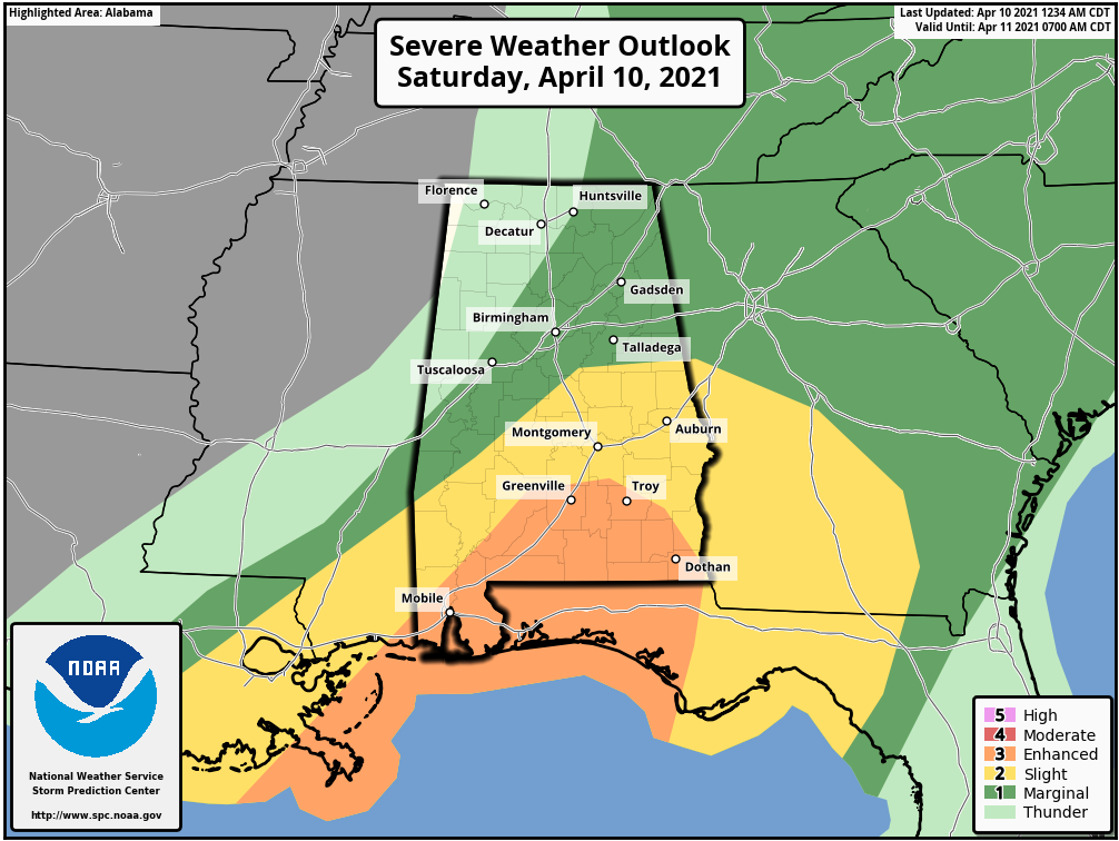
As of the 12:34 am (Saturday) update, the southern three-quarters of Pike County and the extreme southwest corner of Barbour County remain in a level 3/5 Enhanced Risk for severe storms. A level 2/5 Slight Risk is up for locations along and south of a line from Sweet Water (Marengo Co.) to Jemison (Chilton Co.) to in-between Wedowee and Roanoke (Randolph Co.). A level 1/5 Marginal Risk is up for locations along and east of a line from just north of Livingston (Sumter Co.) to Jasper (Walker Co.) to Huntsville (Madison Co.).
The latest model trends have the strongest part of the line moving out of the southeastern parts of the area around 9-11 am with showers and a few embedded thunderstorms continuing across the eastern half of the area until 1-3 pm. Rain for the western half of the area will taper off starting around 8-10 am in the extreme west to around 10 am to 12 pm for the I-65 corridor. Skies will begin to slowly clear out behind the line with afternoon highs reaching the upper 60s to the lower 70s.
THE REST OF THE CENTRAL ALABAMA WEEKEND
Sunday will be a bright and sunny day across the area as troughing will start to work its way out of North/Central Alabama. It will be a nice and mild day with highs ranging from the lower 70s in the northwest to the upper 70s in the southeast.
NEXT WEEK
Monday will be a much warmer day across North/Central Alabama as a flat linear flow sets up across the area. We’ll have plenty of sunshine with highs reaching the upper 70s to the lower 80s.
Tuesday will be a little cooler across parts of the area as we’ll have a weak impulse work across the area that may bring a very slight chance of a few isolated to scattered showers and thunderstorms. Afternoon highs will be in the lower 70s to the lower 80s.
Wednesday will feature a little better chance of showers and thunderstorms mainly during the afternoon hours, but once again, a good many of us will stay dry. Skies will be mostly cloudy with highs in the upper 60s to the upper 70s.
Thursday looks to be a dry day across North/Central Alabama, but skies look to be partly cloudy. Highs will be in the upper 60s to the mid-70s.
Friday looks to be an almost exact copy of Thursday’s weather… a mix of sun and clouds with highs in the upper 60s to the mid-70s.
ON THIS DAY IN WEATHER HISTORY
1979 – An outbreak of 23 tornadoes ravaged the Red River area of Texas and Oklahoma. This day was known as “Terrible Tuesday” to the residents of Wichita Falls, Texas as a tornado rated F4 on the Fujita scale ripped through the city. 3095 homes were destroyed in Wichita Falls. 42 people were killed and total damage was set at $400 million, making it the most costly tornado in history up to this time. The tornado width reached 1.5 miles as it passed through the residential section of the city.
Category: Alabama's Weather, ALL POSTS, Severe Weather, Weather Xtreme Videos
About the Author (Author Profile)
Scott Martin is an operational meteorologist, professional graphic artist, musician, husband, and father. Not only is Scott a member of the National Weather Association, but he is also the Central Alabama Chapter of the NWA president. Scott is also the co-founder of Racecast Weather, which provides forecasts for many racing series across the USA. He also supplies forecasts for the BassMaster Elite Series events including the BassMaster Classic.Subscribe
If you enjoyed this article, subscribe to receive more just like it.


