

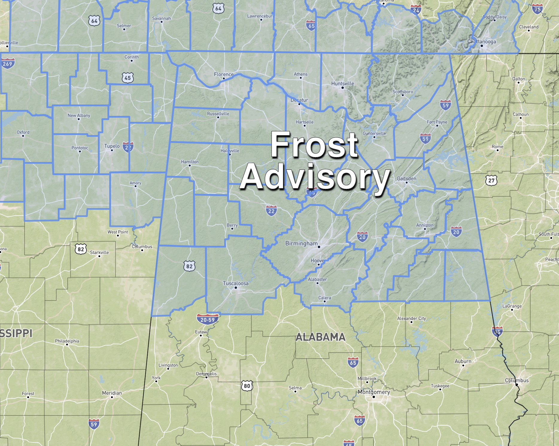
Frost Advisory Tonight For North/Central Alabama
WINDY, COOL APRIL DAY: Temperatures are only in the 50s over the northern half of Alabama this afternoon… about 20-25 degrees below average for April 21. The sky is sunny, but a brisk northwest wind is making it feel cooler. The wind will die down tonight, and with a clear sky and light wind we project a low in the 33-40 degree range for most of North/Central Alabama early tomorrow. A frost advisory is in effect as far south as Pickens, Tuscaloosa, Jefferson, Shelby, Talladega, Clay, and Randolph counties.
Tomorrow will be another sunny day with a high in the mid 60s… we reach the upper 60s Friday with a partly sunny sky. Clouds increase Friday night.
STORMY SATURDAY: A dynamic weather system will bring rain and thunderstorms to Alabama Saturday. The main window for rain comes from about midnight Friday night through 6:00 p.m. Saturday. There will be breaks in the rain, of course, but during that window strong thunderstorms are likely with potential for occasionally heavy rain.
SPC maintains a risk of severe thunderstorms for Central and South Alabama Saturday… for areas along and south of I-20 (Tuscaloosa to Birmingham to Anniston).
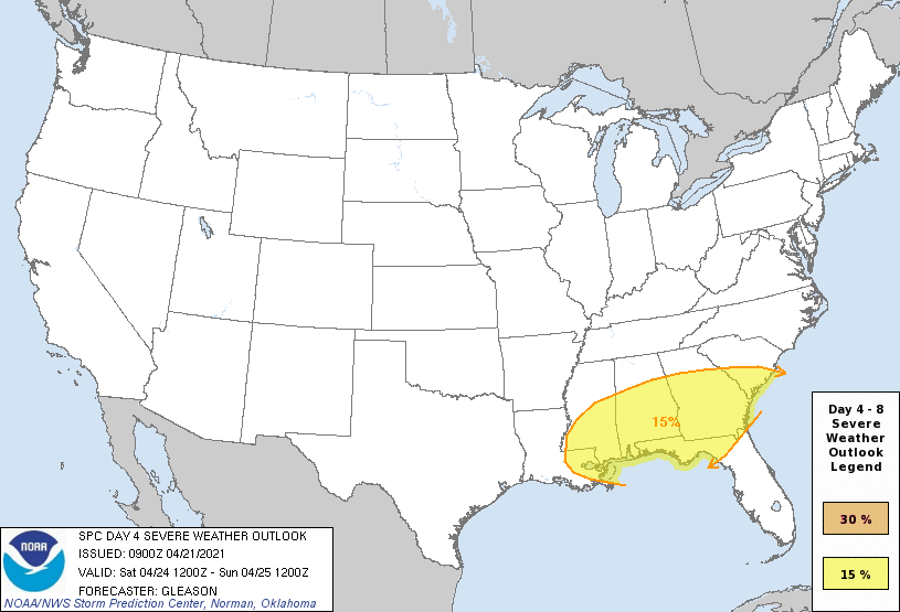
We will be much more specific about the timing of the rain tomorrow, but it is possible the rain comes in two rounds. One during the morning, when isolated tornadoes are possible in the risk area defined by SPC. Another afternoon round comes ahead of a cold front, with the main threat then coming from hail and straight line winds. Rain amounts of 1-2 inches are likely, and some flooding issues could develop during the day where heavier thunderstorms form.
The sky will clear Saturday night as dry air returns, and Sunday will be a sunny day with a high in the low to mid 70s.
NEXT WEEK: Monday and Tuesday will be dry and warm. The high Monday will be close to 80, followed by low to mid 80s Tuesday. The next weather system will bring rain and storms back into Alabama in the Wednesday-Thursday time frame… too early to know if severe storms will be a major issue. See the Weather Xtreme video for maps, graphics, and more details.
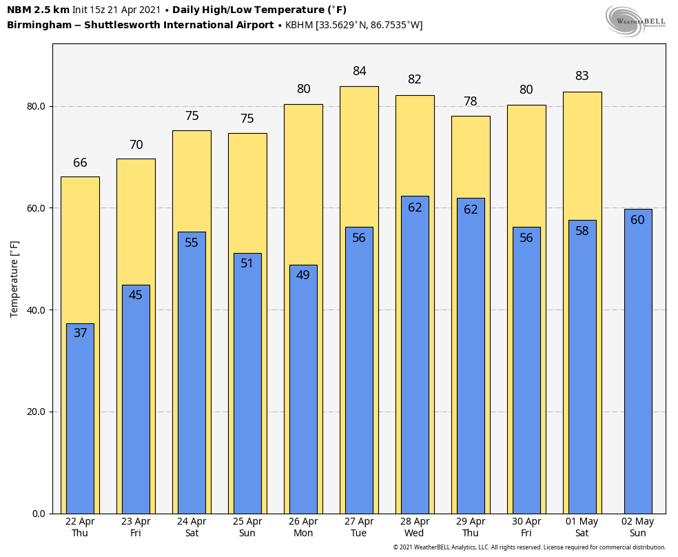
RACE WEEKEND: At Talladega, occasional rain and a few strong thunderstorms are likely Saturday, making it a challenge to get the races in. But, Sunday will be a beautiful day for the Geico 500 with a sunny sky along with a high in the mid 70s.
ON THIS DATE IN 1967: Severe thunderstorms spawned 48 tornadoes in the Upper Midwest. Hardest hit was northern Illinois where sixteen tornadoes touched down during the afternoon and evening hours causing fifty million dollars damage. On that Friday afternoon, tornadoes struck Belvidere IL and the Chicago suburb of Oak Lawn, killing 58 persons.
BEACH FORECAST: Click here to see the AlabamaWx Beach Forecast Center page.
WEATHER BRAINS: Don’t forget you can listen to our weekly 90 minute show anytime on your favorite podcast app. This is the show all about weather featuring many familiar voices, including our meteorologists here at ABC 33/40.
CONNECT: You can find me on all of the major social networks…
Look for the next Weather Xtreme video here by 6:00 a.m. tomorrow…
Category: Alabama's Weather, ALL POSTS, Weather Xtreme Videos
About the Author (Author Profile)
James Spann is one of the most recognized and trusted television meteorologists in the industry. He holds the AMS CCM designation and television seals from the AMS and NWA. He is a past winner of the Broadcast Meteorologist of the Year from both professional organizations.Subscribe
If you enjoyed this article, subscribe to receive more just like it.


