

Showers For Southwest Alabama Today; Dry Elsewhere
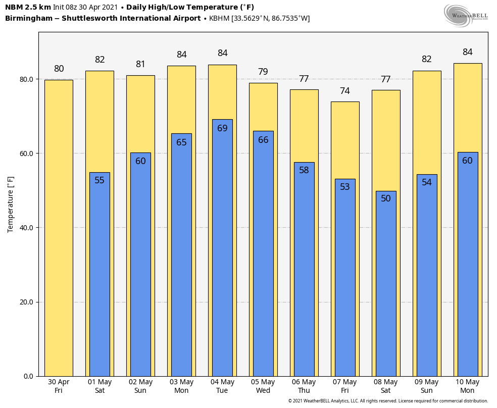
ON THE MAPS: A cold front is pushing into South Alabama early this morning, and we have a few showers and storms on radar over the southwest counties of the state. Showers will remain possible there through the day, but elsewhere the sky becomes partly to mostly sunny as dry air takes over. The high this afternoon will be in the mid to upper 70s; the average high for April 30 at Birmingham is 78.
THE ALABAMA WEEKEND: Tomorrow will be a dry day statewide; with a mostly sunny sky look for a high around 80 degrees. Then, clouds will increase Sunday as moisture levels begin to rise. An organized batch of rain and storms over Mississippi will move into West Alabama late Sunday afternoon, and rain and storms are likely for all of the state Sunday night.
SPC has defined a “slight risk” (level 2/5) of severe thunderstorms for area near the Mississippi border Sunday night, with a “marginal risk” as far east as Moulton, Vance, Pine Hill, and Gulf Shores.
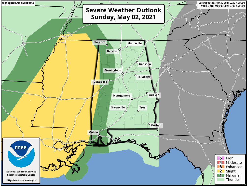
The main threat with the storms Sunday night will come from strong gusty winds and small hail. An isolated tornado can’t be ruled out, but isn’t likely. The rain could be heavy at times.
NEXT WEEK: A moist, unstable airmass will stay in place through much of the week. We will need to mention a chance of showers and thunderstorms on a daily basis Monday through Thursday. Along the way, the rain could be heavy at times, and a few round of strong, possibly severe storms are possible. But, defining the specific windows for the heavier activity is almost impossible to do at this point. Guidance from WPC suggests rain amounts for much of Alabama will be in the 3-5 inch range over the next seven days.
Drier air returns to the state Thursday night, and Friday looks like a dry, pleasant day. See the Weather Xtreme video for maps, graphics, and more details.
ON THIS DATE IN 1924: A significant tornado outbreak occurred from Alabama to Virginia on the 29 through the 30th. 26 tornadoes were of F2 intensity or greater. A total of 111 people were killed, and over 1,100 injured. An estimated F4 tornado tore through Steedman and Horrell Hill, SC. This tornado killed 55 people.
ON THIS DATE IN 1953: An F4 tornado 300 yards in width leveled homes on the north side of Warner-Robins Georgia, and barracks on the south side of the Warner-Robins Air Force Base. 19 people were killed and were 300 injured. Estimated damage was $15 million.
BEACH FORECAST: Click here to see the AlabamaWx Beach Forecast Center page.
WEATHER BRAINS: Don’t forget you can listen to our weekly 90 minute show anytime on your favorite podcast app. This is the show all about weather featuring many familiar voices, including our meteorologists here at ABC 33/40.
CONNECT: You can find me on all of the major social networks…
Look for the next Weather Xtreme video here by 3:00 this afternoon… enjoy the day!
Category: Alabama's Weather, ALL POSTS, Weather Xtreme Videos
About the Author (Author Profile)
James Spann is one of the most recognized and trusted television meteorologists in the industry. He holds the AMS CCM designation and television seals from the AMS and NWA. He is a past winner of the Broadcast Meteorologist of the Year from both professional organizations.Subscribe
If you enjoyed this article, subscribe to receive more just like it.


