

Some Strong Storms Possible Over Southern Parts of the Area, New Watch Likely At This Time
Latest Mesoscale Discussion from the SPC:
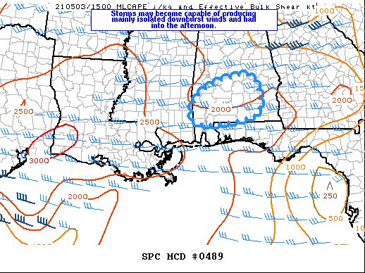
SUMMARY… Storms may become capable of producing mainly isolated damaging wind and hail this afternoon. Trends are being monitored for a possible watch.
DISCUSSION… Latest radar trends show storms continue to increase in coverage in the warm sector across southern AL. This activity is developing along cloud streets as the boundary layer destabilizes, supporting MLCAPE to 2000 J/kg, but with weak mid-level lapse rates. Activity is primarily diurnally driven within a weakly capped but moist environment. Vertical wind profiles will remain modest with 30-35 kt effective bulk shear supporting multicell and occasional marginal supercell structures. Isolated damaging wind appears to be the main threat, but some hail and perhaps a brief tornado or two cannot be ruled out.
Category: Alabama's Weather, ALL POSTS, Severe Weather
About the Author (Author Profile)
Scott Martin is an operational meteorologist, professional graphic artist, musician, husband, and father. Not only is Scott a member of the National Weather Association, but he is also the Central Alabama Chapter of the NWA president. Scott is also the co-founder of Racecast Weather, which provides forecasts for many racing series across the USA. He also supplies forecasts for the BassMaster Elite Series events including the BassMaster Classic.Subscribe
If you enjoyed this article, subscribe to receive more just like it.


