

Strong To Severe Storms Possible Through Tomorrow Night
**No afternoon Weather Xtreme video today due to ongoing active weather**
RADAR CHECK: Scattered showers and strong thunderstorms cover the southern 3/4 of Alabama this afternoon in a warm, moist, unstable airmass. A severe thunderstorm watch is in effect for much of the state through 7:00 p.m.
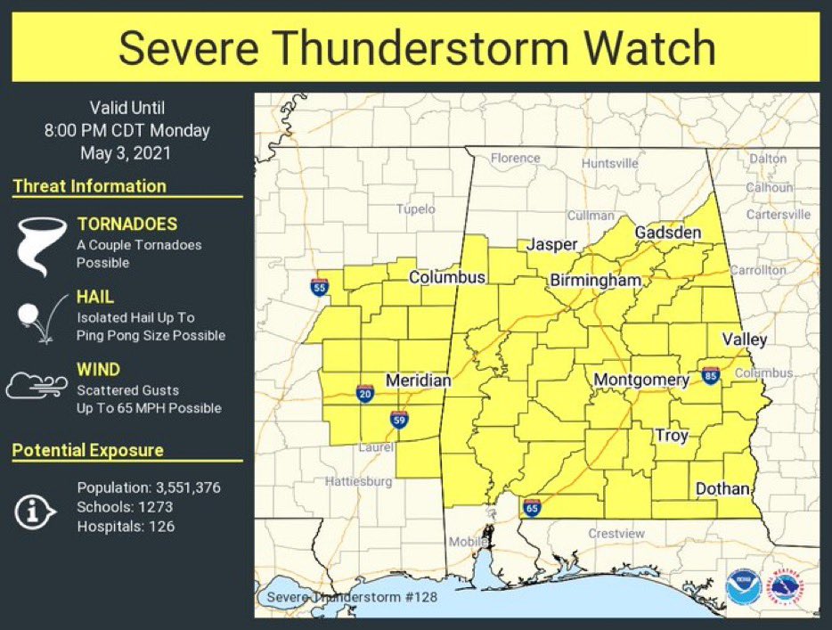
The main threat with thunderstorms through tonight will come from hail and strong straight line winds, although an isolated tornado can’t be ruled out. Storm intensities should decrease late tonight as the air becomes more stable.
TOMORROW: Much of Alabama is in an “enhanced risk” (level 3/5) tomorrow.
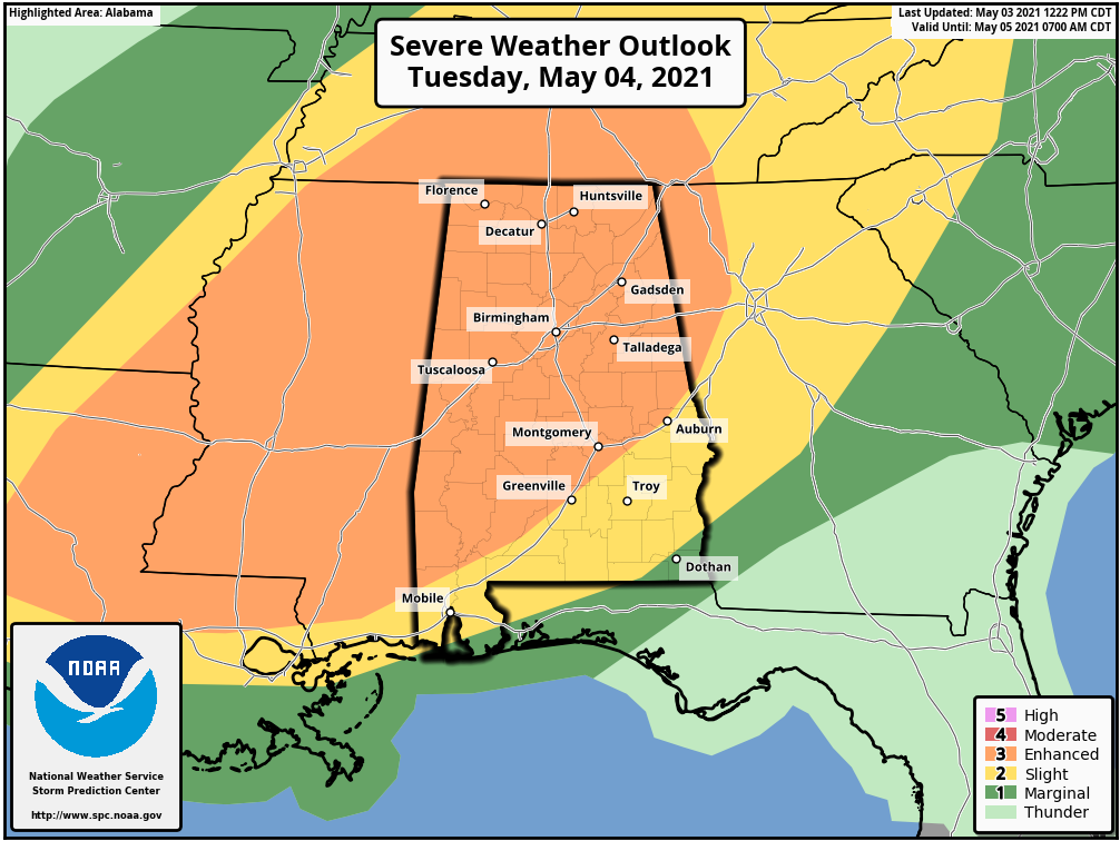
The main window for strong to severe thunderstorms tomorrow will come in the 12 hour window from 9:00 a.m. until 9:00 p.m. Heavier storms will be capable of producing large hail, damaging winds, and a few tornadoes. Like today, the storms will be somewhat scattered and cellular, making it impossible to give a specific ETA for any one community. Just be aware that a number of passing showers and storms are likely tomorrow and tomorrow night.
Additional rain amounts from now through tomorrow night will be in the 1-2 inch range for much of the state; a few spots could see flooding problems where heavier storms develop.
As always, be sure you are in a position to hear severe weather warnings, and have a plan ready in case you come under a tornado warning polygon.
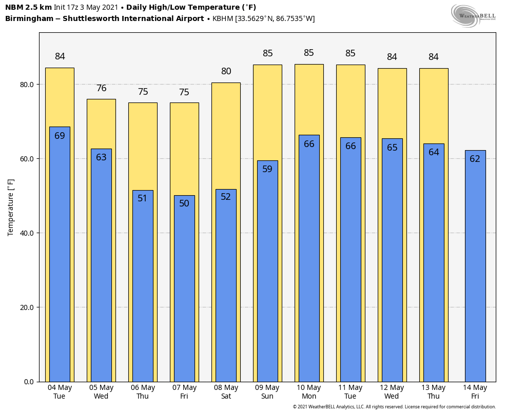
WEDNESDAY THROUGH FRIDAY: Showers will end early Wednesday for North/Central Alabama, and the sky becomes partly sunny by afternoon as dry air returns. Some rain could persist during the day Wednesday over the far southern part of the state. The day will be cooler with a high in the low to mid 70s.
Thursday and Friday will be rain-free for most of Alabama, with partly sunny days and fair nights. Highs will be in the mid 70s, about five degrees below average for early May.
THE ALABAMA WEEKEND: Saturday will feature a good supply of sunshine with a high around 80 degrees. Clouds return Sunday, and we will bring in a chance of showers and thunderstorms by afternoon ahead of a cold front. Sunday will be warm with a high between 81 and 85 degrees.
NEXT WEEK: That front is forecast to become stationary across parts of the Deep South, meaning unsettled weather for much of the week with some risk of showers and storms on just about a daily basis. Highs will be mostly in the low to mid 80s.
ON THIS DATE IN 1999: There were 63 tornadoes in Oklahoma, making this the worst outbreak ever to strike the state. In Central Oklahoma alone, eight individual supercell thunderstorms produced 57 tornadoes. Bridge Creek, Moore and southern parts of the Oklahoma City Metro area were hit the hardest. When it was near Moore, Oklahoma, a truck-mounted Doppler radar measured a wind speed of 318 mph, the highest ever observed in a tornado. Forecasters at the Storm Prediction Center in Norman, OK were faced with the unprecedented situation of a major tornado on the ground threatening their location. As a major F5 tornado was approaching the Oklahoma City metro area from the southwest, the SPC notified its backup, the Air Force Weather Agency at Offutt AFB in Omaha, Nebraska that they might have to assume operational responsibility if the tornado approached Norman. The storm remained several miles west of the facility but was visible from the SPC roof. Damage from this single tornado was around one billion dollars, making it the most costly tornado in history.
BEACH FORECAST: Click here to see the AlabamaWx Beach Forecast Center page.
WEATHER BRAINS: Don’t forget you can listen to our weekly 90 minute show anytime on your favorite podcast app. This is the show all about weather featuring many familiar voices, including our meteorologists here at ABC 33/40.
CONNECT: You can find me on all of the major social networks…
Look for the next Weather Xtreme video here by 6:00 a.m. tomorrow…
Category: Alabama's Weather, ALL POSTS, Weather Xtreme Videos
About the Author (Author Profile)
James Spann is one of the most recognized and trusted television meteorologists in the industry. He holds the AMS CCM designation and television seals from the AMS and NWA. He is a past winner of the Broadcast Meteorologist of the Year from both professional organizations.Subscribe
If you enjoyed this article, subscribe to receive more just like it.


