

Severe T-Storm Watch May Need to Be Extended in Time for Southeastern Parts of the Area
Here is the latest Mesoscale Discussion from the SPC:
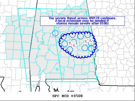
SUMMARY… Ongoing severe storms may pose a risk for isolated damaging wind gusts and severe hail after the 8 pm watch expiration of the severe thunderstorm watch. A local extension may be needed.
DISCUSSION… A cluster of severe storms across east-central Alabama in the vicinity of Montgomery has shown occasional organization and severe characteristics over the last hour. These storms are ongoing in a partially modified unstable airmass with surface temperatures in the upper 70s and dewpoints in the upper 60s. SPC mesoanalysis indicates between 2000-2500 J/kg of MLCAPE with 30-40 kts of effective shear. The loss of diurnal heating should result in only marginal boundary-layer cooling suggesting that storms may retain intensity beyond 8 pm. Given the favorable parameter space and occasional updraft rotation noted, isolated damaging wind gusts and severe hail will remain possible. A local extension of the severe thunderstorm watch may be needed to account for the threat past 8 pm.
Category: Alabama's Weather, ALL POSTS, Severe Weather
About the Author (Author Profile)
Scott Martin is an operational meteorologist, professional graphic artist, musician, husband, and father. Not only is Scott a member of the National Weather Association, but he is also the Central Alabama Chapter of the NWA president. Scott is also the co-founder of Racecast Weather, which provides forecasts for many racing series across the USA. He also supplies forecasts for the BassMaster Elite Series events including the BassMaster Classic.Subscribe
If you enjoyed this article, subscribe to receive more just like it.


