

Strong To Severe Storms Likely Across Alabama Through Tonight
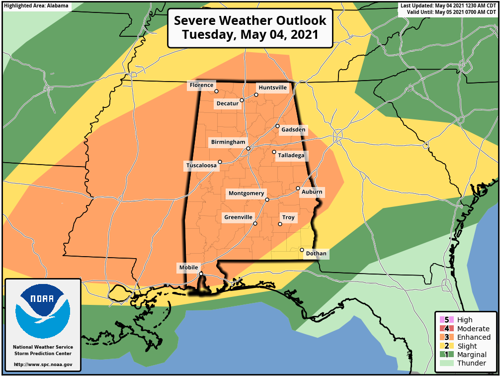
ANOTHER ACTIVE DAY AHEAD: We have another active weather day ahead for Alabama as we will deal with multiple rounds of strong to severe thunderstorms. SPC has most of the state in an “enhanced risk” (level 3/5) through tonight.
TIMING: There will be basically three rounds of storms today. The first will impact the far northern tier of counties; a severe thunderstorm watch is in effect for Lauderdale, Limestone, Madison, and Jackson counties of far North Alabama until 11:00 this morning. An organized batch of storms moving through Tennessee could clip those four counties… elsewhere widely scattered showers and storms (non-severe) continue early this morning across the rest of the state.
The second round will come between 9:00 a.m. and 1:00 p.m… these storms will impact mainly the northern half of Alabama. Then, the third and most impactful batch of storms will come statewide this afternoon and tonight, generally from 3:00 p.m. until 10:00 p.m.
THREATS: The main concern will come from the third round of storms this afternoon and tonight… they will have potential to bring damaging straight line winds and a few isolated tornadoes. Some hail is possible as well. The SPC probabilistic outlook shows most of Alabama will have a 30-45 percent chance of damaging winds within 25 miles of a given point.
RAIN: Rain amounts of 1-2 inches are likely over the next 24 hours, and some flooding issues are possible. A flash flood watch is in effect for the southwest counties of the state.
As always, be sure you are in a position to hear severe weather watches and warnings today and tonight, and pay attention to severe thunderstorm warnings since the main concern is from damaging straight line winds.
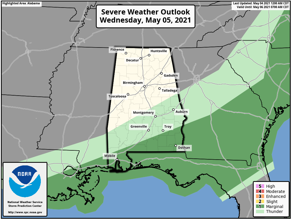
Drier air moves into the northern half of Alabama early tomorrow; any lingering showers will end most likely by daybreak, and the sky becomes partly sunny tomorrow afternoon. A few showers or storms could linger over South Alabama through early afternoon; SPC has a “marginal risk” (level 1) defined for the far southern part of the state.
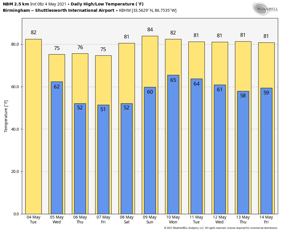
THURSDAY THROUGH THE WEEKEND: Look for dry weather Thursday through Saturday with mostly sunny days and fair nights. The high Thursday and Friday will be in the mid 70s, then we rise to near 80 degrees Saturday. Clouds will increase Sunday, and showers and storms will arrive late in the day and into Sunday night. Sunday will be a warm day with a high in the mid 80s.
NEXT WEEK: A stalled surface front will bring a good chance of showers and storms to Alabama Monday and Tuesday… then we see a trend toward drier weather over the latter half of the week. See the Weather Xtreme video for maps, graphics, and more details.
ON THIS DATE IN 2007: A devastating EF5 tornado demolishes nearly every structure in Greensburg, Kansas around 9:30 pm (CDT) and kills ten. The mammoth wedge tornado cuts a swath 1.7 miles wide and 22 miles long across the Kansas landscape. It is the worst single tornado to touch down in the US in eight years.
BEACH FORECAST: Click here to see the AlabamaWx Beach Forecast Center page.
WEATHER BRAINS: Don’t forget you can listen to our weekly 90 minute show anytime on your favorite podcast app. This is the show all about weather featuring many familiar voices, including our meteorologists here at ABC 33/40.
CONNECT: You can find me on all of the major social networks…
Look for the next Weather Xtreme video here by 3:00 this afternoon… enjoy the day!
Category: Alabama's Weather, ALL POSTS, Weather Xtreme Videos
About the Author (Author Profile)
James Spann is one of the most recognized and trusted television meteorologists in the industry. He holds the AMS CCM designation and television seals from the AMS and NWA. He is a past winner of the Broadcast Meteorologist of the Year from both professional organizations.Subscribe
If you enjoyed this article, subscribe to receive more just like it.


