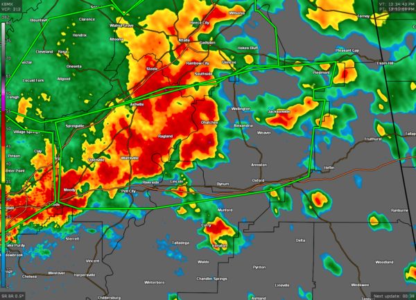
EXTENDED Flash Flood Warning for Parts of St. Clair, Calhoun, Talladega, Etowah Co. Until 4:00 pm
The National Weather Service in Birmingham has issued a
* Flash Flood Warning for…
St. Clair County in central Alabama…
Calhoun County in east central Alabama…
Northeastern Talladega County in east central Alabama…
Southeastern Etowah County in northeastern Alabama…
* Until 230 PM CDT.
* At 1235 PM CDT, Doppler radar indicated thunderstorms producing
heavy rain across the warned area. Flash flooding is ongoing or
expected to begin shortly.
HAZARD…Flash flooding caused by thunderstorms.
SOURCE…Doppler radar.
IMPACT…Flooding of small creeks and streams, urban areas,
highways, streets and underpasses as well as other
drainage and low lying areas.
* Some locations that will experience flash flooding include…
Anniston, Oxford, Pell City, Jacksonville, Leeds, Moody, Rainbow
City, Piedmont, Springville, Odenville, West End-Cobb Town, Saks,
Cobb Town, Fort McClellan, Lincoln, Glencoe, Margaret, Argo,
Weaver and Ashville.
PRECAUTIONARY/PREPAREDNESS ACTIONS…
Turn around, don’t drown when encountering flooded roads. Most flood
deaths occur in vehicles.
Category: Alabama's Weather, ALL POSTS, Severe Weather


