

Flash Flood Warning for Parts of Jefferson, Shelby, St. Clair Co. Until 5:00 pm
The National Weather Service in Birmingham has issued a
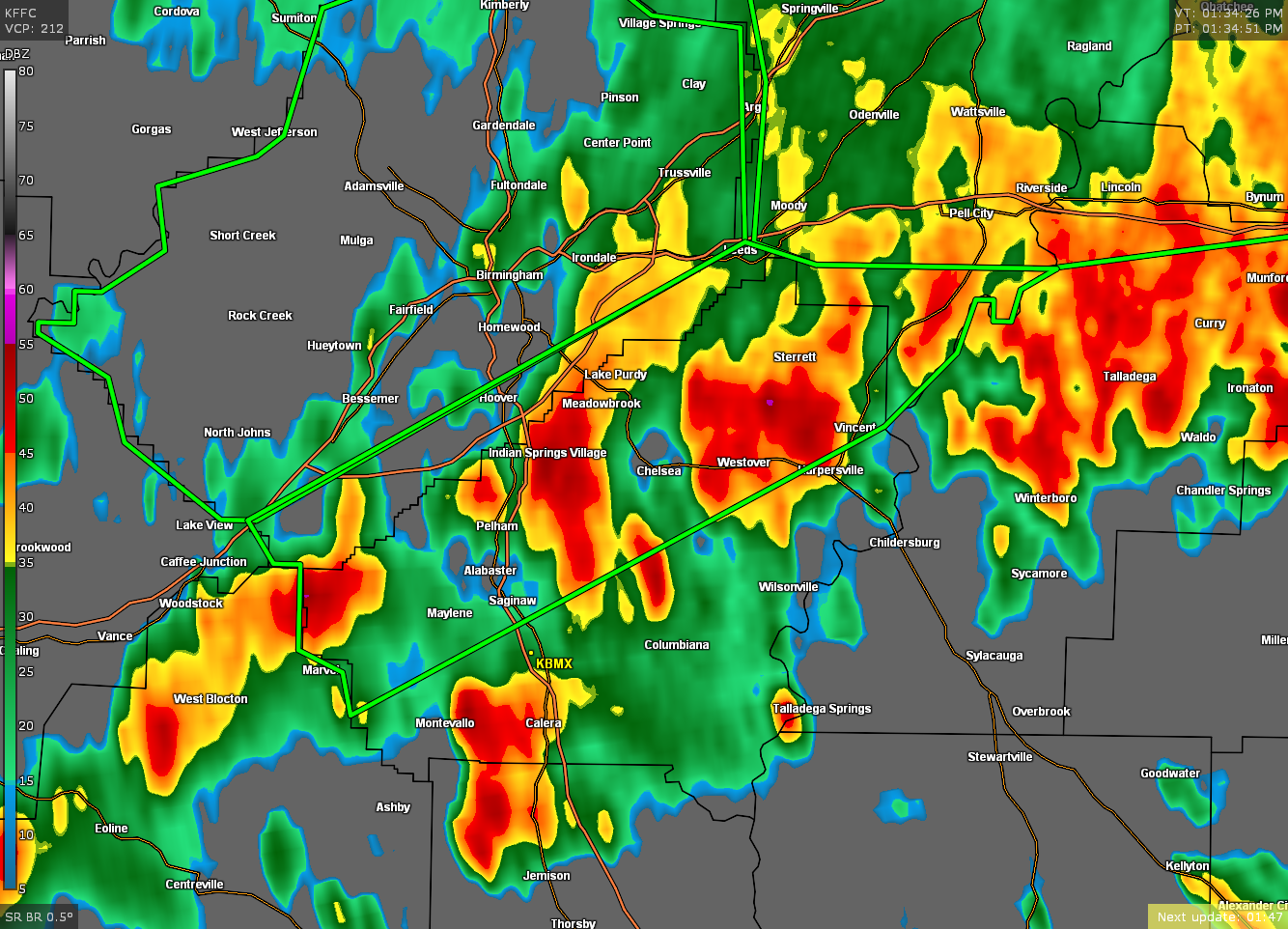
* Flash Flood Warning for…
Southeastern Jefferson County in central Alabama…
Southwestern St. Clair County in central Alabama…
Central Shelby County in central Alabama…
* Until 500 PM CDT.
* At 139 PM CDT, Doppler radar indicated thunderstorms producing
heavy rain across the warned area. Between 1 and 2 inches of rain
have fallen. Flash flooding is ongoing or expected to begin
shortly.
HAZARD…Flash flooding caused by thunderstorms.
SOURCE…Doppler radar.
IMPACT…Flooding of small creeks and streams, urban areas,
highways, streets and underpasses as well as other
drainage and low lying areas.
* Some locations that will experience flash flooding include…
Hoover, Vestavia Hills, Alabaster, Bessemer, Pelham, Mountain
Brook, Helena, Pell City, Leeds, Moody, Chelsea, Indian Springs
Village, Vincent, Harpersville, Westover, Meadowbrook, Highland
Lakes, Inverness, Oak Mountain State Park and Fowler Lake.
Additional rainfall amounts of 1 to 2 inches are possible in the
warned area.
PRECAUTIONARY/PREPAREDNESS ACTIONS…
Turn around, don’t drown when encountering flooded roads. Most flood
deaths occur in vehicles.
Excessive runoff from heavy rainfall will cause flooding of small
creeks and streams, urban areas, highways, streets and underpasses
as well as other drainage areas and low lying spots.
Category: Alabama's Weather, ALL POSTS, Severe Weather
About the Author (Author Profile)
Scott Martin is an operational meteorologist, professional graphic artist, musician, husband, and father. Not only is Scott a member of the National Weather Association, but he is also the Central Alabama Chapter of the NWA president. Scott is also the co-founder of Racecast Weather, which provides forecasts for many racing series across the USA. He also supplies forecasts for the BassMaster Elite Series events including the BassMaster Classic.Subscribe
If you enjoyed this article, subscribe to receive more just like it.


