

CANCELED Tornado Warning for Parts of Elmore, Montgomery Co. Until 7:00 pm
The National Weather Service in Birmingham has issued a
* Tornado Warning for…
Southern Elmore County in east central Alabama…
North central Montgomery County in south central Alabama…
* Until 700 PM CDT.
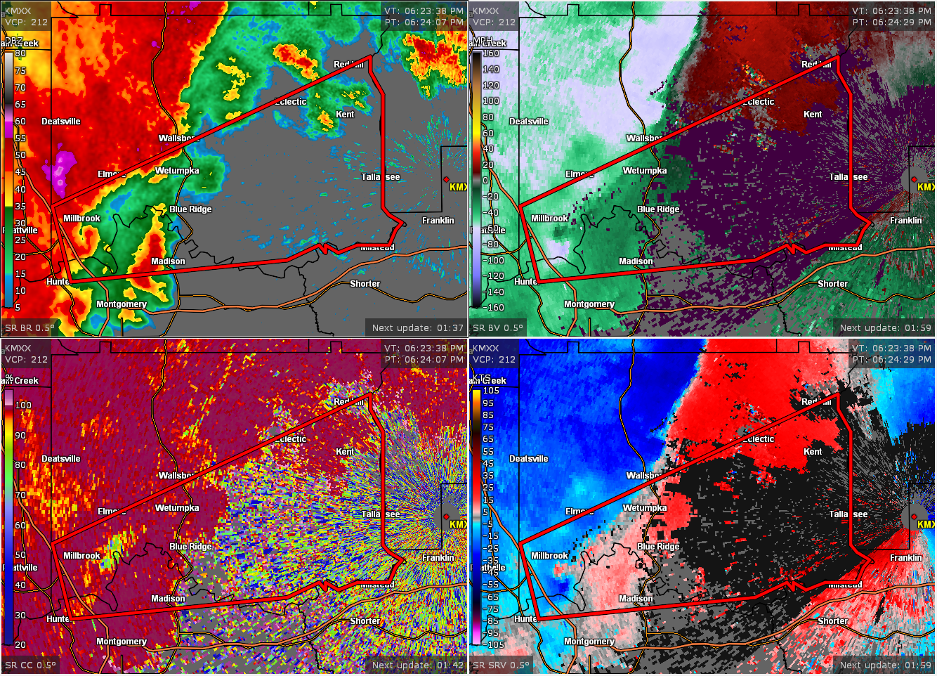
* At 624 PM CDT, a severe thunderstorm capable of producing a tornado
was located over Coosada, or near Millbrook, moving east at 55 mph.
HAZARD…Tornado.
SOURCE…Radar indicated rotation.
IMPACT…Flying debris will be dangerous to those caught without
shelter. Mobile homes will be damaged or destroyed.
Damage to roofs, windows, and vehicles will occur. Tree
damage is likely.
* Locations impacted include…
Northwestern Montgomery, Prattville, Millbrook, Wetumpka,
Tallassee, Elmore, Coosada, Eclectic, Montgomery Zoo, Boylston, Bob
Woodruff Lake, Emerald Mountain, Blue Ridge, Martin Dam, Southern
Lake Martin, Claud, Wetumpka Municipal Airport, Ware, Tallapoosa
Water Plant and Yates Reservoir.
PRECAUTIONARY/PREPAREDNESS ACTIONS…
TAKE COVER NOW! Move to a basement or an interior room on the lowest
floor of a sturdy building. Avoid windows. If you are outdoors, in a
mobile home, or in a vehicle, move to the closest substantial shelter
and protect yourself from flying debris.
Category: Alabama's Weather, ALL POSTS, Severe Weather
About the Author (Author Profile)
Scott Martin is an operational meteorologist, professional graphic artist, musician, husband, and father. Not only is Scott a member of the National Weather Association, but he is also the Central Alabama Chapter of the NWA president. Scott is also the co-founder of Racecast Weather, which provides forecasts for many racing series across the USA. He also supplies forecasts for the BassMaster Elite Series events including the BassMaster Classic.Subscribe
If you enjoyed this article, subscribe to receive more just like it.


