

Periods Of Rain Possible Through Wednesday, Then Drier
RADAR CHECK: Rain covers parts oF East and South Alabama early this morning; there is some lighting over the southern counties of the state but storms are well below severe limits. Otherwise, the sky is cloudy statewide with temperatures in the 60s. A surface front is becoming stationary over the state, and we will have some risk of scattered showers through tonight, but the day won’t be a “wash-out” by any means. Some thunder will remain possible over South Alabama this afternoon, where SPC has defined a low end “marginal risk” south of a line from Demopolis to Eufaula.
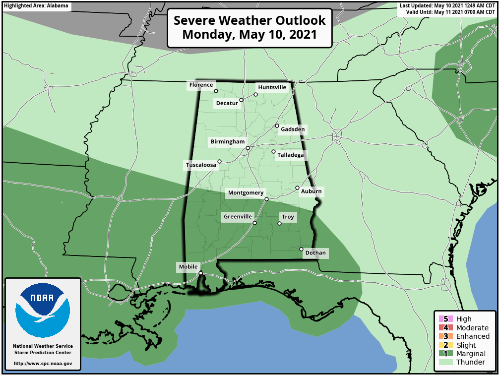
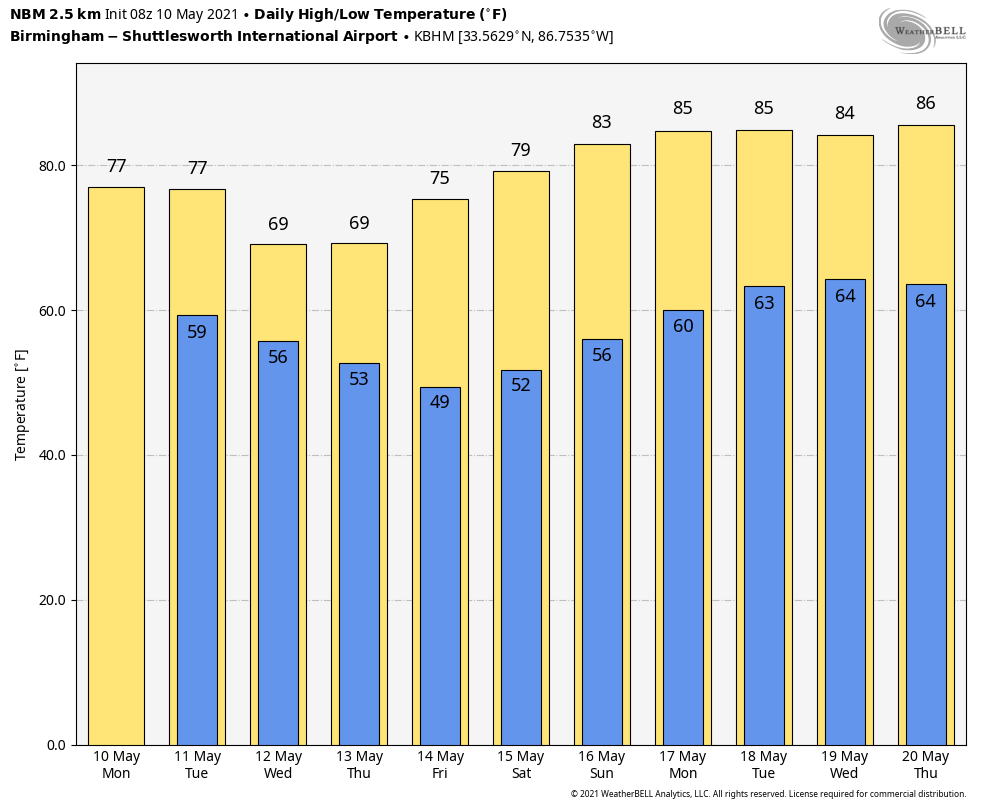
Heavier storms in that area could produce small hail and gusty winds this afternoon and early tonight. The high this afternoon will be in the 70-75 degree range… the average high for Birmingham on May 10 is 81.
TOMORROW/WEDNESDAY: Cloudy weather continues tomorrow with a risk of scattered showers during the day, but rain becomes widespread tomorrow night as a wave moves along the stalled front. A few stronger storms are possible over South Alabama, where a “marginal risk” stays in place, but the overall severe weather threat is low. Wednesday will be mostly cloudy and cool; temperatures won’t get out of the 60s over the northern half of the state. A few showers remain possible during the day Wednesday, but the rain won’t be especially heavy or widespread.
THURSDAY THROUGH THE WEEKEND: Clouds will linger into Thursday morning, but the day will be generally dry with some afternoon clearing possible. Temperatures remain well below average with a high between 65 and 70 degrees. Then, look for sunshine in full force Friday and Saturday with a warming trend. The high Friday will be in the mid 70s, and we will be close to 80 degrees by Saturday afternoon. And, Sunday will feature a partly sunny sky with a high in the low 80s.
NEXT WEEK: For now it looks like an upper ridge will build across the Southeast U.S… meaning warm and generally dry weather for at least the first half of the week. Temperatures will rise into the mid 80s… See the Weather Xtreme video for maps, graphics, and more details.
TROPICS: The first tropical storm of the season has formed in the eastern Pacific. Tropical Storm Andres has winds of only 40 mph, and will dissipate far from land over the next day or two well west of Mexico. The season for the Atlantic basin begins June 1.
ON THIS DATE IN 2006: An EF-1 tornado moved through Marengo County in West Alabama, producing damage in Linden. Flash flooding also affected Linden. Several roadways were temporarily impassable due to high water and a few buildings suffered water damage.
ON THIS DATE IN 2010: Oklahoma experienced its largest tornado outbreak since May 3, 1999. Fifty-five twisters tore through the state, including two rated EF4. The EF4 storms took three lives and injured 81 people. Ironically, both EF4 tornadoes struck Norman, Oklahoma, home of the Storm Prediction Center and the National Severe Storms Laboratory. Fourteen additional tornadoes hit Oklahoma during May 11-13. The May 10 disaster racked up insured property losses of $2 billion.
BEACH FORECAST: Click here to see the AlabamaWx Beach Forecast Center page.
WEATHER BRAINS: Don’t forget you can listen to our weekly 90 minute show anytime on your favorite podcast app. This is the show all about weather featuring many familiar voices, including our meteorologists here at ABC 33/40.
CONNECT: You can find me on all of the major social networks…
Look for the next Weather Xtreme video here by 3:00 this afternoon… enjoy the day!
Category: Alabama's Weather, ALL POSTS, Weather Xtreme Videos
About the Author (Author Profile)
James Spann is one of the most recognized and trusted television meteorologists in the industry. He holds the AMS CCM designation and television seals from the AMS and NWA. He is a past winner of the Broadcast Meteorologist of the Year from both professional organizations.Subscribe
If you enjoyed this article, subscribe to receive more just like it.


