

Sunny Memorial Day; Rain Chances Return Later This Week
COOL MORNING: We have another refreshingly cool morning across Alabama with temperatures well below average; here are some reports at sunrise…
Black Creek 45
Fort Payne 46
Gadsden 46
Haleyville 48
Weaver 49
Meridianville 49
Scottsboro 50
Leeds 51
Pell City 52
Huntsville 53
Anniston 55
Tuscaloosa 56
Birmingham 59
Mobile 61
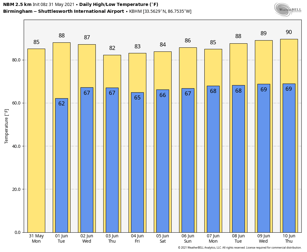
Today will feature sunshine in full supply with a high in the low to mid 80s; the average high for Birmingham on May 31 is 85.
REST OF THE WEEK: Dry weather continues tomorrow with a partly sunny sky; the high will be in the mid 80s. We will bring in a chance of afternoon showers or storms Wednesday as moisture levels rise, but still much of the day will be dry with a high in the low to mid 80s. Then, on Thursday and Friday, we expect scattered to numerous showers and thunderstorms both days as an unsettled weather pattern develops for the region. The sky feature more clouds than sun both days with highs in the low 80s.
THE ALABAMA WEEKEND: Not much change; we will deal with scattered showers and thunderstorms Saturday and Sunday across Alabama. Most of them, but not necessarily all, will come during the afternoon and evening hours, and odds of any one spot getting will be around 60 percent Saturday, and 40 percent Sunday. The showers and storms will be random and scattered, like most summer days, and there isn’t a way of knowing in advance exactly when and where they pop up. Highs over the weekend will be in the 80s.
NEXT WEEK: For low it looks like a pretty routine June week, with some risk of “scattered, mostly afternoon and evening showers and thunderstorms” on a daily basis with highs in the 80s. See the Weather Xtreme video for maps, graphics, and more details.
TROPICS: The Atlantic basin is quiet, and tropical storm formation is not expected this week. The official start to the Atlantic season is tomorrow.
ON THIS DATE IN 2013: An intense, long-track tornado formed southwest of El Reno, Oklahoma. This exceptionally wide tornado took a complex path, rapidly changing in both speed and direction. The tornado spared El Reno and its airport from a direct hit, tracking just south of those locations. The tornado damaged numerous homes along with a few businesses near El Reno. Additionally, intense sub-vortices destroyed crops in numerous fields in the area. Eight people were killed in the tornado, all in vehicles. This included three severe storm researchers who were killed east of U.S. Highway 81 as the tornado overtook their position. Additionally, several other people were killed while attempting to escape the tornado near U.S. Highway 81. Finally, two people were killed along I-40 while waiting for the storm to pass.
BEACH FORECAST: Click here to see the AlabamaWx Beach Forecast Center page.
WEATHER BRAINS: Don’t forget you can listen to our weekly 90 minute show anytime on your favorite podcast app. This is the show all about weather featuring many familiar voices, including our meteorologists here at ABC 33/40.
CONNECT: You can find me on all of the major social networks…
Just one Weather Xtreme video today as we are on a holiday schedule, but I will post forecast notes this afternoon. Enjoy the day!
Category: Alabama's Weather, ALL POSTS, Weather Xtreme Videos
About the Author (Author Profile)
James Spann is one of the most recognized and trusted television meteorologists in the industry. He holds the AMS CCM designation and television seals from the AMS and NWA. He is a past winner of the Broadcast Meteorologist of the Year from both professional organizations.Subscribe
If you enjoyed this article, subscribe to receive more just like it.


