

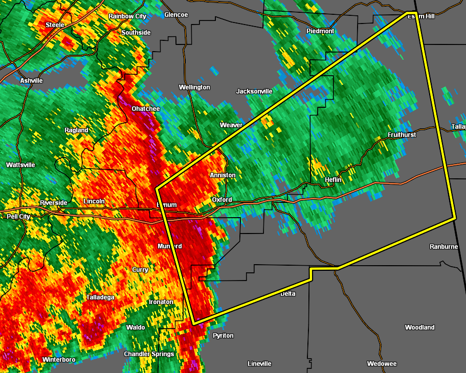
EXPIRED Severe T-Storm Warning for Parts of Talladega, Calhoun, Cleburne, Clay Co. Until 6:30 pm
The National Weather Service in Birmingham has issued a
* Severe Thunderstorm Warning for…
Northeastern Talladega County in east central Alabama…
Southeastern Calhoun County in east central Alabama…
Cleburne County in east central Alabama…
Northeastern Clay County in east central Alabama…
* Until 630 PM CDT.
* 
HAZARD…60 mph wind gusts.
SOURCE…Radar indicated.
IMPACT…Expect damage to roofs, siding, and trees.
* Locations impacted include…
Anniston, Oxford, Heflin, Cobb Town, West End-Cobb Town, Fort
McClellan, Saks, Munford, Hobson City, Fruithurst, Edwardsville,
Anniston Regional Airport, Blue Mountain, Muscadine, Abernathy,
Oxford Lake, Bynum, Mars Hills, Mount Cheaha and Coleman Lake And
Campground.
PRECAUTIONARY/PREPAREDNESS ACTIONS…
For your protection move to an interior room on the lowest floor of a
building.
Category: Alabama's Weather, ALL POSTS, Severe Weather
About the Author (Author Profile)
Scott Martin is an operational meteorologist, professional graphic artist, musician, husband, and father. Not only is Scott a member of the National Weather Association, but he is also the Central Alabama Chapter of the NWA president. Scott is also the co-founder of Racecast Weather, which provides forecasts for many racing series across the USA. He also supplies forecasts for the BassMaster Elite Series events including the BassMaster Classic.Subscribe
If you enjoyed this article, subscribe to receive more just like it.


