

Midday Nowcast: Flash Flooding Remains a Concern
RADAR CHECK: It has been a very wet morning for much of North/Central Alabama with areas of heavy rainfall. Flash flooding continues to be a concern and the Flash Flood Watch remains in effect until this evening.
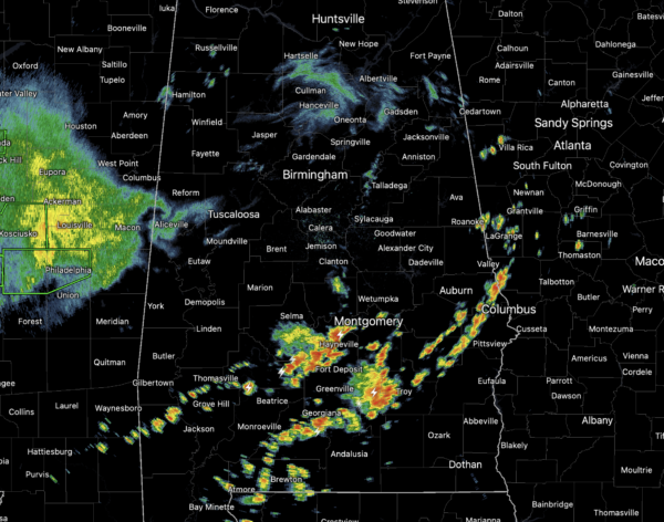
At the midday hours, the heavy rain and storm activity has decreased in coverage and intensity across North/Central Alabama, while the more intense activity is over southern portions of the state. Through the afternoon and evening hours, rain and storms will continue to be a threat for many locations. Where it is not raining, we are seeing more clouds than sun, with temperatures in the 80s, while 70s are more common in areas seeing rain.
FRIDAY AND THE WEEKEND: More of the same to end the work week tomorrow, with more clouds than sun, and scattered to numerous showers and thunderstorms, and again, tropical downpours are likely. Then, for Saturday and Sunday, showers and storms should become fewer in number with increasing amounts of sunshine. Rain chances will return to more seasonal values for mid-June in Alabama; roughly in the 30-40 percent range, Saturday dropping to 20 percent Sunday. Highs over the weekend will be between 87 and 92 degree range.
FOR NEXT WEEK: Finally, better model agreement in regards to next week and they show a much drier airmass dropping into Alabama through the week. Though showers and storms coverage will drop considerably, they will not go away completely, and will become more isolated in nature. Highs Monday and Tuesday will be around 90°, but then will drop into the low to mid-80s for the rest of the week. Dewpoints will be considerably lower, and some North Alabama communities could drop into the 50s over the latter half of the week.
BEACH FORECAST CENTER: Get the latest weather and rip current forecasts for the beaches from Fort Morgan to Panama City on our Beach Forecast Center page. There, you can select the forecast of the region that you are interested in visiting.
WORLD TEMPERATURE EXTREMES: Over the last 24 hours, the highest observation outside the U.S. was 120.0F at Nuwasib, Kuwait. The lowest observation was -101.2F at University Dome, Antarctica.
CONTIGUOUS TEMPERATURE EXTREMES: Over the last 24 hours, the highest observation was 114F at Rio Grande Village, TX. The lowest observation was 23F at Old Station, CA.
Category: Alabama's Weather, ALL POSTS
About the Author (Author Profile)
Macon, Georgia Television Chief Meteorologist, Birmingham native, and long time Contributor on AlabamaWX. Stormchaser. I did not choose Weather, it chose Me. College Football Fanatic. @Ryan_StinnetSubscribe
If you enjoyed this article, subscribe to receive more just like it.


