

A Few Strong Storms Today; Could We See Tropical Mischief At The End of the Week?
The Central Alabama Weekend
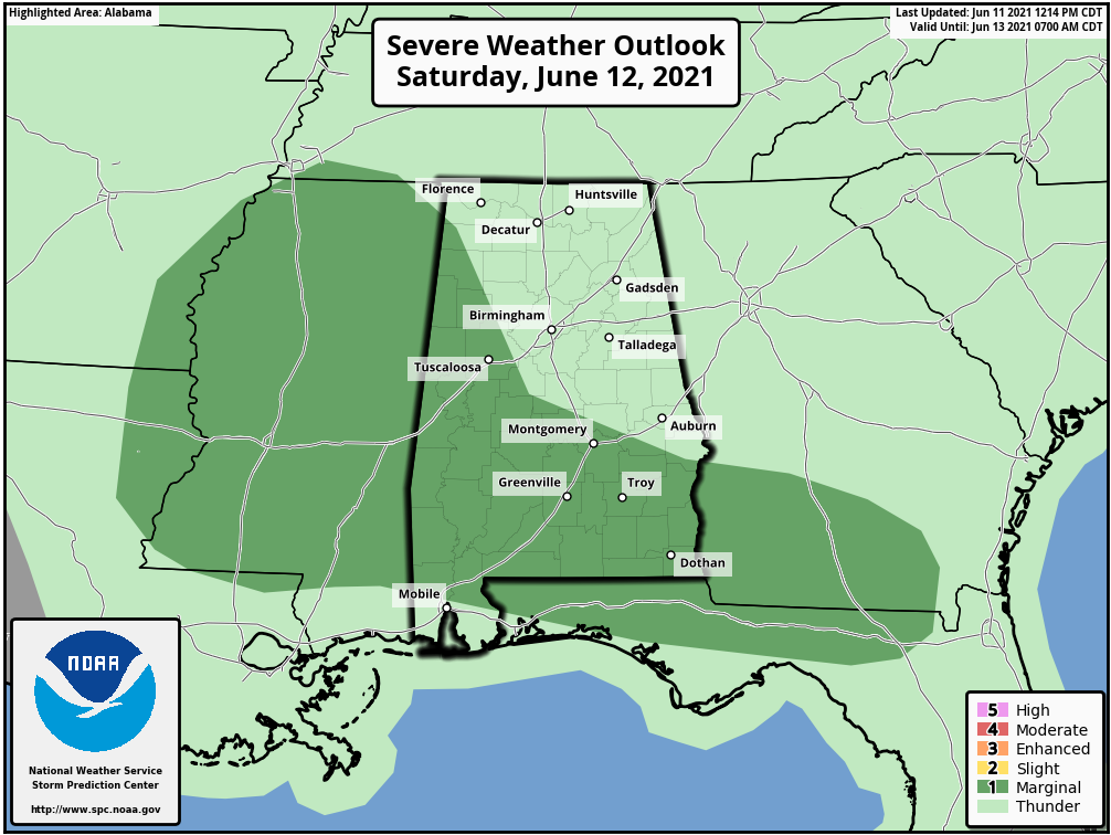
We’ll have a shortwave boundary that will move through Central Alabama on Saturday that will be a focal point for the formation of thunderstorms during the main heating of the day, some of these storms may become strong to severe with the potential of isolated damaging wind gusts up to 60 mph. The main window for those stronger to potentially severe storms will be from roughly 1 pm to 8 pm along and south of a line from Double Springs to Birmingham to Auburn.
As of the late Friday evening update from the SPC, a level 1/5 Marginal Risk is up for locations along and south of a line from the White Oak Community (Franklin Co.) to Centreville (Bibb Co.) to Pittsview (Russell Co.).
Prior to that activity, scattered showers and storms will be possible during the morning hours for portions of Central Alabama while the rest start off with partly to mostly cloudy skies. It will be humid and sticky as the afternoon highs will reach the upper 80s to the lower 90s.
That shortwave boundary will wash out over the extreme southern portions of the state on Sunday and will keep much of the shower and storm activity to our south. However, a few isolated to scattered afternoon showers will be possible mainly over the southern half of Central Alabama. Highs will be in the upper 80s to the lower 90s.
The Workweek Ahead
Monday will be another hot day across Central Alabama with only a very small chance of an isolated shower or storm for much of the area, with a slightly higher chance for locations along and south of I-85 and US-80. Highs will once again be in the upper 80s to the lower 90s.
The rest of the workweek looks to be dry with plenty of sunshine as a northerly flow sets up over Central Alabama. Any showers and storms will be south of the area mainly along and south of I-10. The air will be less humid and temperatures will be more comfortable once we leave the oven on Tuesday. Tuesday’s highs will top out in the upper 80s to the mid-90s, then dropping back into the lower 80s to the lower 90s on Wednesday. Thursday’s highs will be just a touch cooler as everyone will be in the 80s.
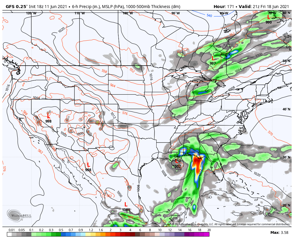
We start to warm back up a little on Friday with highs getting into the mid-80s to the lower 90s across the area, but the latest GFS model run shows the potential of some rain associated with a tropical low moving onshore during the early morning hours and continuing to slowly move northward during the day which would bring a strong possibility of rain for nearly all of Central Alabama. The European model agrees with the potential of a tropical low, but it has it arriving a full day later and a little farther to the west over the Central Louisiana Gulf Coast. Just too early to call at this point. We’ll keep our eyes on it.
Tropical Update
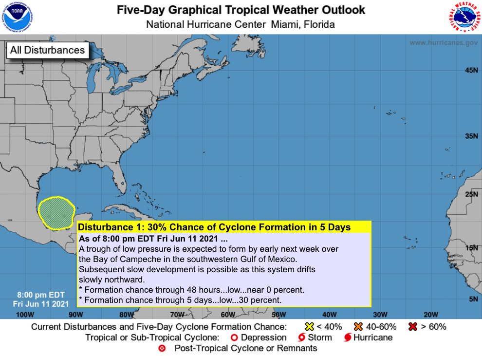
And speaking of tropical weather… The National Hurricane Center is forecasting a low forming early next week over the Bay of Campeche in the southwestern Gulf of Mexico and has it slowly drifting northward throughout the week with the potential of some slow development. For now, it only has a 30% chance of forming into at least a depression within the next five days. The rest of the Tropical Atlantic Basin is free from any tropical systems.
On This Day in Weather History
1881 – Severe thunderstorms spawned more than half a dozen tornadoes in the Lower Missouri Valley. Five of the tornadoes touched down near Saint Joseph MO. In south-central Kansas, a tornado nearly wiped out the town of Floral. Hail and high winds struck Iowa and southern Minnesota. In Minnesota, Blue Earth City reported five inches of rain in one hour.
1989 – Thunderstorms produced severe weather from Tennessee Valley to the Central Appalachians in the afternoon and evening, and produced severe weather in Oklahoma and Texas during the evening and night. Thunderstorms spawned ten tornadoes, and there were 164 reports of large hail and damaging winds. Thunderstorms produced wind gusts to 100 mph at Amarillo, TX, and wind gusts to 110 mph at Denton TX. Hail three inches in diameter was reported at Tucumcari NM.
Beach Forecast Center
Get the latest weather and rip current forecasts for the beaches from Dauphin Island, AL, to Panama City Beach, FL, on our Beach Forecast Center page. There, you can select the forecast of the region that you are interested in.
Advertise on the Blog!
We had a record-breaking year in 2020 with over 20 million page views! We are already on a record-shattering pace to break that mark in 2021 as we are already over 15 million page views so far! Don’t miss out! We can customize a creative, flexible, and affordable package that will suit your organization’s needs. Contact Bill Murray at (205) 687-0782.
E-Forecast
Get the Alabama Wx Weather Blog’s Seven-Day Forecast delivered directly to your inbox by email twice daily. It is the most detailed weather forecast available in Central Alabama. Subscribe here… It’s free!
Connect With the Blog on Social Media
You can find the AlabamaWx Weather Blog on the major social media networks:
Facebook
Twitter
WeatherBrains
There are several ways to watch or listen to the podcast that is all about the weather. Watch live starting at 8:00 pm CT on Monday nights at live.bigbrainsmedia.com, James Spann’s YouTube Channel, or on one of ABC 3340’s digital weather channels (17.2, 40.2, 68.3). Listen to the recorded audio podcast at WeatherBrains.com or on your favorite podcast platform (Apple Podcasts, Stitcher, Spotify, etc.), or watch the recorded video on James Spann’s YouTube channel.
Category: Alabama's Weather, ALL POSTS, Severe Weather, Tropical, Weather Xtreme Videos
About the Author (Author Profile)
Scott Martin is an operational meteorologist, professional graphic artist, musician, husband, and father. Not only is Scott a member of the National Weather Association, but he is also the Central Alabama Chapter of the NWA president. Scott is also the co-founder of Racecast Weather, which provides forecasts for many racing series across the USA. He also supplies forecasts for the BassMaster Elite Series events including the BassMaster Classic.Subscribe
If you enjoyed this article, subscribe to receive more just like it.


