

Drier Air Rolling Into North Alabama
RADAR CHECK: A surface boundary, representing the leading edge of drier air, is pushing through North Alabama this afternoon. A few isolated showers and storms have formed ahead of the front; heavier storms are over East-Central Alabama at mid- afternoon around the I-85 corridor. Those storms will continue to push southward over the next few hours as the dry air moves into the northern half of the state. Temperatures are mostly in the 90-94 degree range… some some places today is the hottest day so far in 2021.
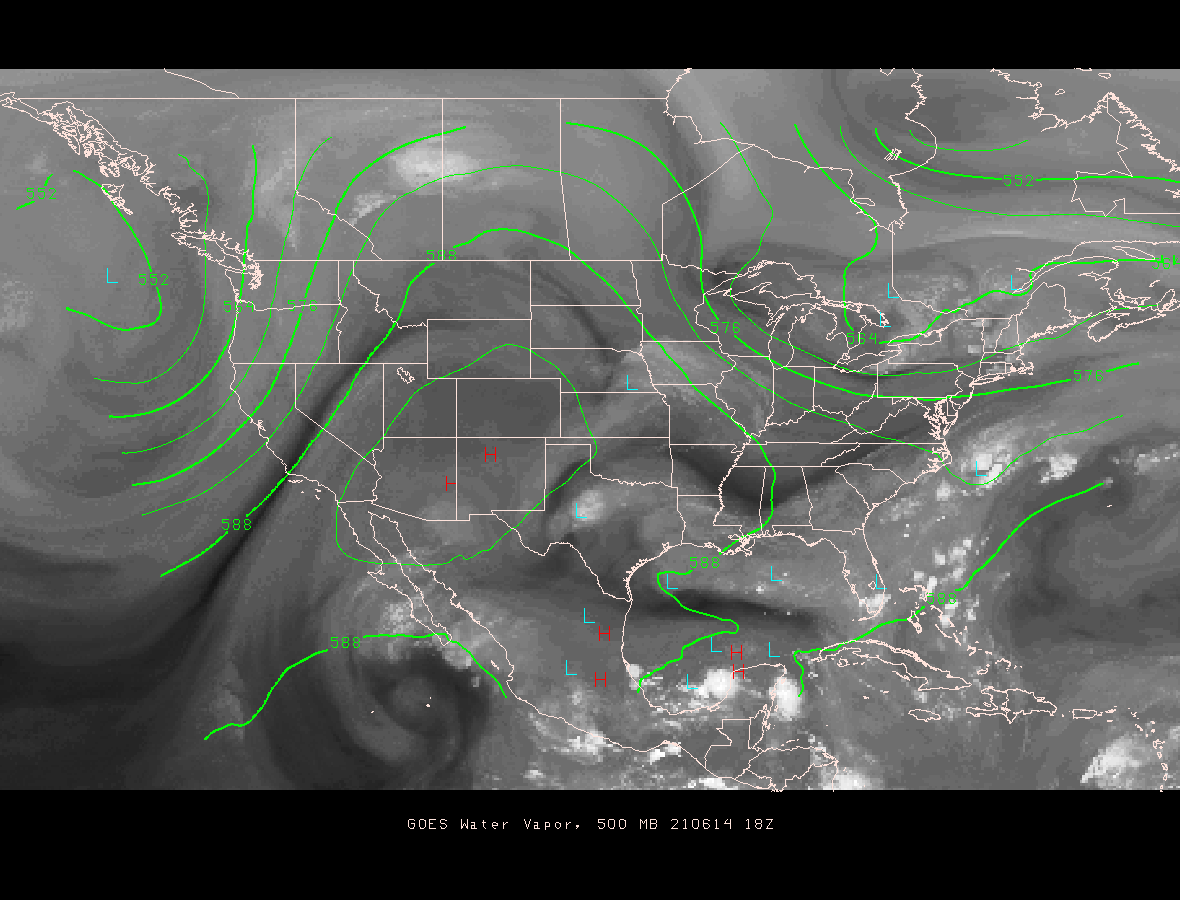
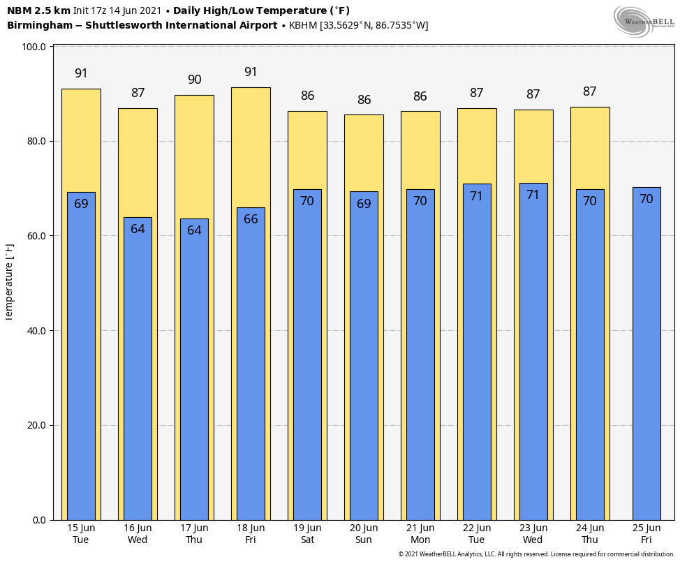
REST OF THE WEEK: Tomorrow will feature sunshine in full supply for most of the state with lower humidity levels. Any scattered thunderstorms will be confined to the coast, and some of them there could be strong. The weather continues to look mostly rain-free Wednesday through Friday with partly to mostly sunny days, fair nights, and only very isolated showers. Highs will be mostly in the mid to upper 80s, with lows in the 60s. Cooler pockets could reach the upper 50s across North/Central Alabama Wednesday and Thursday morning.
THE ALABAMA WEEKEND: A tropical low is expected to bring rain back to the state, but exactly when that rain begins is hard to define at this point. We will bring in an enhanced chance of rain and a few thunderstorms Saturday night and Sunday, but the rain could very well begin during the day Saturday as the low moves into Louisiana.
It is possible rain could become heavy at times Saturday night and Sunday, but again, it is simply too early to be specific on rain totals. Highs over the weekend will be in the 80s.
NEXT WEEK: Showers should diminish Monday as the tropical low weakens and lifts out, and the rest of the week should feature fairly routine summer weather with partly sunny days and the chance of “scattered, mostly afternoon and evening showers and thunderstorms”. Highs through the week should be in the upper 80s… right at seasonal averages. See the Weather Xtreme video for maps, graphics, and more details.
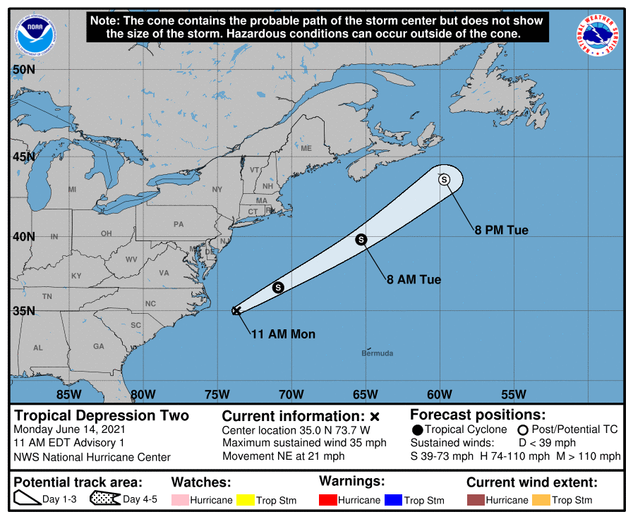
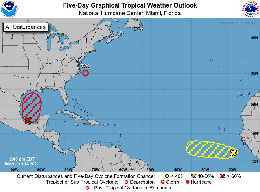
TROPICS: Tropical Depression two has formed in the Atlantic, off the coast of North Carolina. It could briefly become Tropical Storm Bill tonight or tomorrow… then it weakens and becomes post-tropical east of the Canadian maritimes. No threat to the U.S.
A tropical depression is forecast to develop in the Southwest Gulf of Mexico within 72 hours; this is forecast to move northward in the general direction of the Louisiana coast by Friday or Saturday. The main impact from this system will be heavy rain and rip currents; the rain shield will spread into Alabama over the weekend.
And, in the far eastern Atlantic, a strong tropical wave located several hundred miles south- southeast of the Cabo Verde Islands is maintaining a large but disorganized area of shower and thunderstorm activity. Some development of this system is possible during the next few days before a combination of dry air aloft and strong upper-level winds limit any chance of formation while the wave is over the central tropical Atlantic Ocean late this week.
ON THIS DATE IN 1903: Major flash flooding along Willow Creek destroyed a significant portion of Heppner, Oregon on this day. With a death toll of 247 people, it remains the deadliest natural disaster in Oregon.
BEACH FORECAST: Click here to see the AlabamaWx Beach Forecast Center page.
WEATHER BRAINS: Don’t forget you can listen to our weekly 90 minute show anytime on your favorite podcast app. This is the show all about weather featuring many familiar voices, including our meteorologists here at ABC 33/40.
CONNECT: You can find me on all of the major social networks…
Look for the next Weather Xtreme video here by 6:00 a.m. tomorrow…
Category: Alabama's Weather, ALL POSTS, Weather Xtreme Videos
About the Author (Author Profile)
James Spann is one of the most recognized and trusted television meteorologists in the industry. He holds the AMS CCM designation and television seals from the AMS and NWA. He is a past winner of the Broadcast Meteorologist of the Year from both professional organizations.Subscribe
If you enjoyed this article, subscribe to receive more just like it.


