

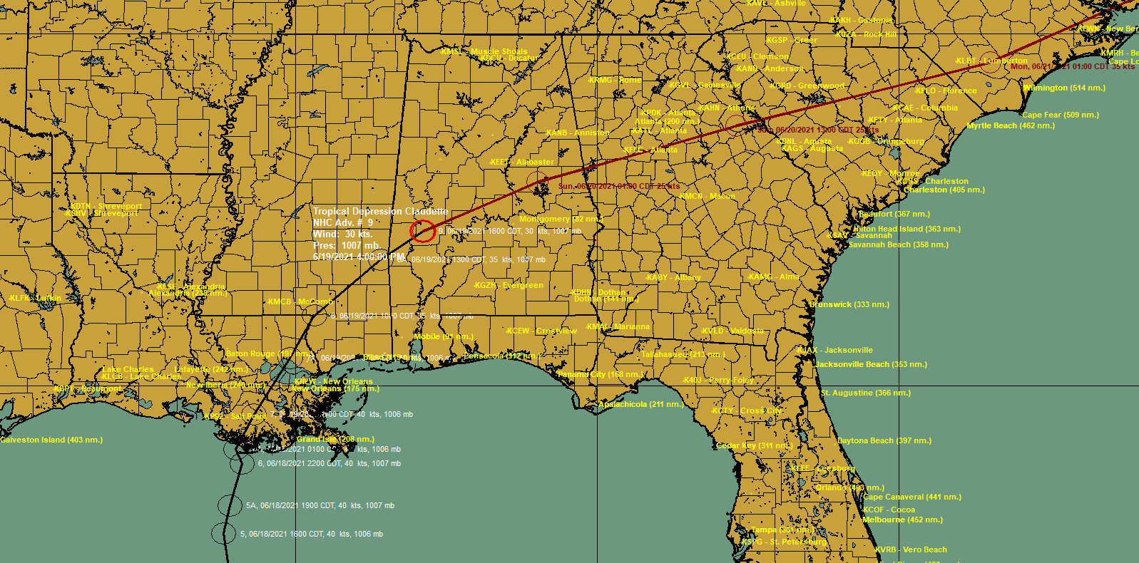
4 p.m. Advisory: Claudette Weakens to a Depression Over Southwest Alabama
The center of Tropical Depression Claudette is over southwestern Alabama in Marengo County near Sweet Water.
It is still producing gusty winds and heavy rain across Southwest Alabama.
A tornado watch continues for Southeast Alabama and Southwest Georgia until 7 p.m.
Flash flood watches continue across South and Central Alabama and well as Georgia and the Carolinas.
BULLETIN
Tropical Depression Claudette Advisory Number 9
NWS National Hurricane Center Miami FL AL032021
400 PM CDT Sat Jun 19 2021
…HEAVY RAINS AND GUSTY WINDS CONTINUE ACROSS PORTIONS OF THE
SOUTHEAST U.S…
SUMMARY OF 400 PM CDT…2100 UTC…INFORMATION
———————————————-
LOCATION…32.2N 87.9W
ABOUT 95 MI…150 KM W OF MONTGOMERY ALABAMA
ABOUT 105 MI…170 KM N OF MOBILE ALABAMA
MAXIMUM SUSTAINED WINDS…35 MPH…55 KM/H
PRESENT MOVEMENT…NE OR 40 DEGREES AT 16 MPH…26 KM/H
MINIMUM CENTRAL PRESSURE…1007 MB…29.74 INCHES
WATCHES AND WARNINGS
——————–
CHANGES WITH THIS ADVISORY:
The Tropical Storm Warning on the Gulf coast has been discontinued.
SUMMARY OF WATCHES AND WARNINGS IN EFFECT:
A Tropical Storm Watch is in effect for…
* Cape Fear to Duck, North Carolina
* Pamlico and Albemarle Sounds
A Tropical Storm Watch means that tropical storm conditions are
possible within the watch area, in this case within the next 36 to
48 hours.
Interests elsewhere across the southeast U.S. should monitor the
progress of this system.
For storm information specific to your area, including possible
inland watches and warnings, please monitor products issued by your
local National Weather Service forecast office.
DISCUSSION AND OUTLOOK
———————-
At 400 PM CDT (2100 UTC), the center of Tropical Depression
Claudette was located near latitude 32.2 North, longitude 87.9 West.
The depression is moving toward the northeast near 16 mph (26
km/h). A turn toward the east-northeast is expected tonight and
Sunday. On the forecast track, the system should move farther
inland across portions of the southeast U.S. through Sunday night,
and over the western Atlantic Ocean on Monday.
Maximum sustained winds have decreased to near 35 mph (55 km/h)
with higher gusts. Claudette is expected to weaken a little more
tonight, however, it is forecast to become a tropical storm again
when it moves across the Carolinas Sunday night or early Monday.
The estimated minimum central pressure based on surface
observations is 1007 mb (29.74 inches).
HAZARDS AFFECTING LAND
———————-
Key messages for Claudette can be found in the Tropical Cyclone
Discussion under AWIPS header MIATCDAT3, WMO header WTNT43 KNHC,
and on the web at
www.hurricanes.gov/graphics_at3.shtml?key_messages.
RAINFALL: Claudette is expected to produce additional rainfall
totals of 3 to 6 inches with isolated maximum amounts of 8 inches
across eastern Alabama, northern Georgia, the Florida Panhandle, and
South and North Carolina. Flash, urban and small stream flooding
impacts as well as new and renewed minor to isolated moderate river
flooding are likely across these areas.
The storm total rainfall is expected to be 5 to 10 inches with
isolated 15 inch totals in southeast Louisiana, southern
Mississippi, southern Alabama, and the western Florida panhandle.
STORM SURGE: The combination of storm surge and the tide will
cause normally dry areas near the coast to be flooded by rising
waters moving inland from the shoreline. The water could reach the
following heights above ground somewhere in the indicated areas if
the peak surge occurs at the time of high tide…
Cape Lookout, NC to NC/VA Border…1-3 ft
Surge-related flooding depends on the relative timing of the surge
and the tidal cycle, and can vary greatly over short distances. For
information specific to your area, please see products issued by
your local National Weather Service forecast office.
WIND: Tropical storm conditions are possible in the watch area
Sunday night and Monday.
TORNADOES: A few tornadoes are possible this evening and tonight
across southeast Alabama, the western Florida Panhandle, and
southwest Georgia.
NEXT ADVISORY
————-
Next intermediate advisory at 700 PM CDT.
Next complete advisory at 1000 PM CDT.
$$
Forecaster Cangialosi
Category: Alabama's Weather, ALL POSTS, Severe Weather, Tropical
About the Author (Author Profile)
Bill Murray is the President of The Weather Factory. He is the site's official weather historian and a weekend forecaster. He also anchors the site's severe weather coverage. Bill Murray is the proud holder of National Weather Association Digital Seal #0001 @wxhistorianSubscribe
If you enjoyed this article, subscribe to receive more just like it.


