

A Look at Alabama Weather Situation at 8 p.m.
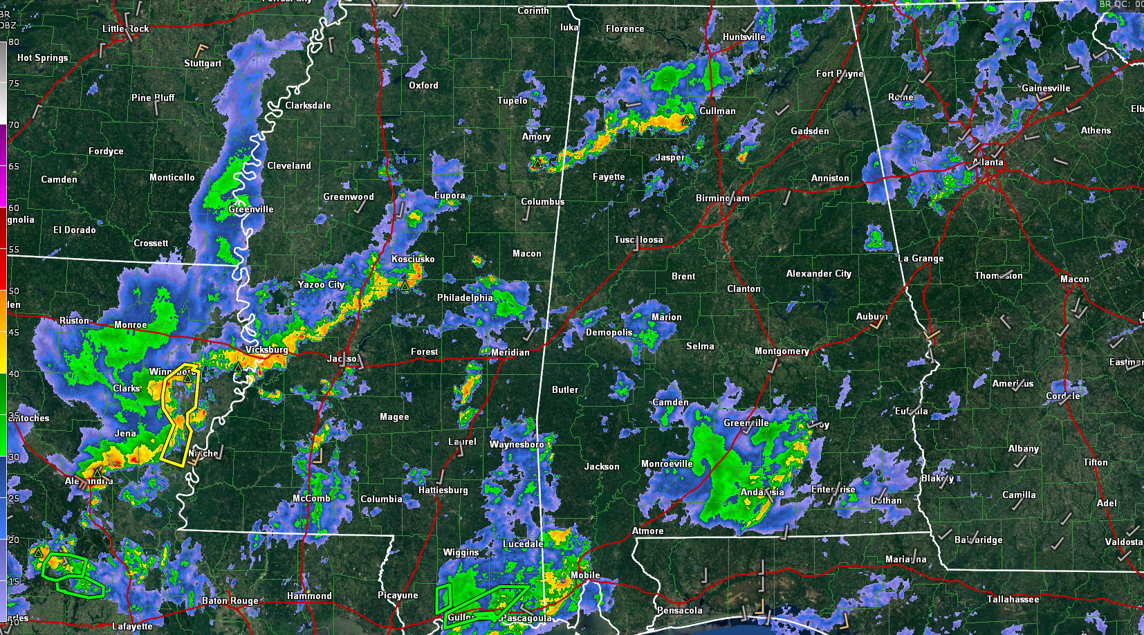
Showers and thunderstorms have decreased in coverage and intensity this evening across Central Alabama. One storm is moving from southern Cullman into Blount County.
Over South Alabama, a large area of rain and thunder is pushing northeastward across areas from Camden to Monroeville to Greenville and Andalusia.
But the storms of concern for tonight are ahead of a cold front that now extends from northern Louisiana to near the Northwest Corner of Alabama to east of Nashville.
A few storms are occurring now over Marion, Winston, and northern Lamar Counties to the Columbus, MS area in advance of the front. There is a lot of lightning associated with these storms. From there, there is a break in the line, with stronger storms extending from Kosciusko to east of Yazoo City to Vicksburg and onto Alexandria LA. There have been a few severe thunderstorm warnings in Central Mississippi and eastern Louisiana over the past couple of hours.
The front and line of storms are slightly ahead of schedule. But the question is whether additional storms will fire later this evening like our convection-allowing models show. So there is a great deal of uncertainty about whether the storms will be able to maintain their intensity. If they do, they will have the capacity to produce damaging winds. In any case, they will cause heavy rain. With all of our recent heavy rain, quick downpours could cause local flooding.
The highest risk for those damaging wind gusts is generally along and northwest of I-59. It is a low-end threat, and somewhat conditional, but even low-end threats can result in tragedies.
So please make sure you have your source for warnings turned on overnight and react if a severe thunderstorm warning is issued for your location. Even one downed tree on a home can kill.
The storms should weaken with time. They will reach the Tuscaloosa – Birmingham – Gadsden areas around 1 a.m. There could be a few showers in the post-frontal zone into early Tuesday morning.
We could see the storms refire tomorrow afternoon for areas south of I-65/I-85 in South Alabama. Those storms could become severe, with damaging winds again the main threat.
We should see clearing skies in the afternoon across North and Central Alabama. It will be a mild day tomorrow with highs in the 70s north to near 80 in the I-20 Corridor with lower 80s over South Central Alabama.
It looks like the northern half of Alabama will remain dry Wednesday. A few showers or storms could return to Central Alabama on Thursday and Friday as the Ring of Fire sets up over Alabama on the periphery of the subtropical high to our east.
Showers and storm chances look better for the weekend, but no washout for sure.
Interestingly, the GFS is spinning up a tropical cyclone in the eastern Gulf at the end of the month. That is serious voodoo territory, so not a forecast for sure. But will be interesting to watch.
Category: Alabama's Weather, ALL POSTS, Severe Weather
About the Author (Author Profile)
Bill Murray is the President of The Weather Factory. He is the site's official weather historian and a weekend forecaster. He also anchors the site's severe weather coverage. Bill Murray is the proud holder of National Weather Association Digital Seal #0001 @wxhistorianSubscribe
If you enjoyed this article, subscribe to receive more just like it.


