

Midday Nowcast: Sun North, Clouds South
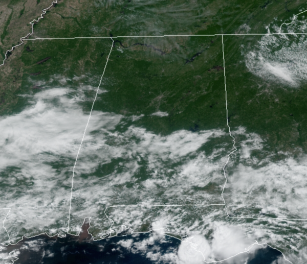
As we approach the midday hours, we are seeing mainly sunny conditions across North Alabama, while more clouds are present to the south. Temperatures are in the 70s and 80s and will be heading into the mid-80s for most locations across the state.
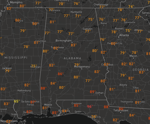
For North/Central Alabama the rest of this week, expect the days to feature a mix of sun and clouds while afternoon temperatures range between the mid to upper 80s. Rain chances are near zero today for the northern half of the state, but moisture levels begin to climb tomorrow, so scattered showers and storms will return to the radar as they pop-up across the Alabama landscape tomorrow and Friday.
WEEKEND WEATHER: For both Saturday and Sunday, not much change in the forecast with showers and storms possible, mainly during the afternoon and evening hours. The days will be partly sunny, while nights will be mostly fair. Highs this weekend will continue to hold in the mid to upper 80s.
NEXT WEEK: The weather pattern doesn’t change much as we head through the final days of June and head into July. The days will feature partly sunny and warm conditions with highs in the 80s, which are a few degrees below average for this time of year. Also, it will remain muggy, so during the afternoon and evening hours showers and storms will be showing up on the radar across the Alabama landscape. Also, some model data suggest we could see higher rain chances by the middle of next week, with more numerous showers and storms likely.
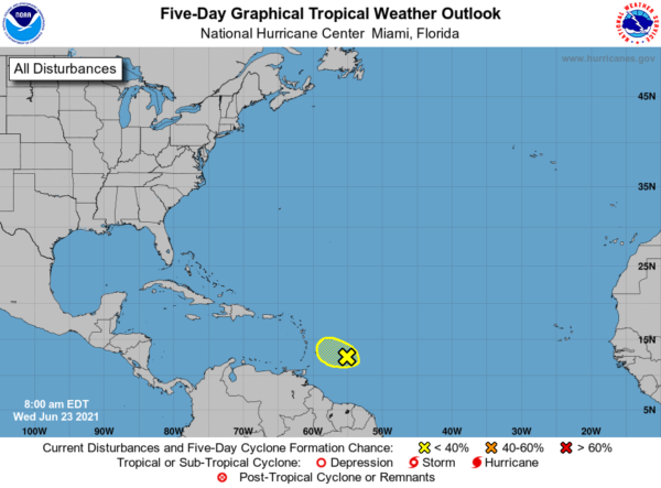
IN THE TROPICS: Showers and thunderstorms associated with a tropical wave located a few hundred miles east of the Windward Islands remain disorganized. Additional development of this system is unlikely while moving west-northwestward at 5 to 10 mph into an area of stronger upper-level winds by Thursday. Formation chance through 5 days…low…10 percent. The next name up on the list…Danny.
BEACH FORECAST CENTER: Get the latest weather and rip current forecasts for the beaches from Fort Morgan to Panama City on our Beach Forecast Center page. There, you can select the forecast of the region that you are interested in visiting.
WORLD TEMPERATURE EXTREMES: Over the last 24 hours, the highest observation outside the U.S. was 127.8F at Nuwasib, Kuwait. The lowest observation was -101.9F at University Dome, Antarctica.
CONTIGUOUS TEMPERATURE EXTREMES: Over the last 24 hours, the highest observation was 117F at Death Valley and Stovepipe Wells, CA. The lowest observation was 27F at Leota, MI.
WEATHER ON THIS DATE IN 1944: Four tornadoes killed 153 persons and caused five million dollars damage in Pennsylvania, West Virginia and Maryland. The tornadoes formed during the evening and moved southeast along parallel paths flattening everything in their way. The town of Shinnston, WV was leveled, and was left with the majority of the casualties. Until that time it was believed that damaging tornadoes did not travel across mountainous terrain.
Category: Alabama's Weather, ALL POSTS
About the Author (Author Profile)
Macon, Georgia Television Chief Meteorologist, Birmingham native, and long time Contributor on AlabamaWX. Stormchaser. I did not choose Weather, it chose Me. College Football Fanatic. @Ryan_StinnetSubscribe
If you enjoyed this article, subscribe to receive more just like it.


