

Midday Nowcast: Remnants of Danny Heading West, More Showers and Storms this Afternoon
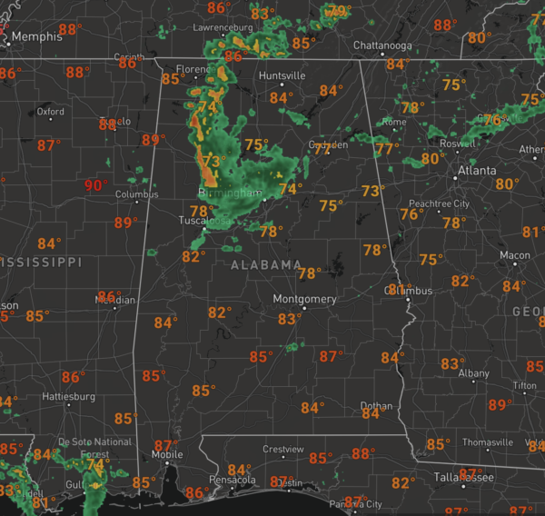
The remnants of Danny brought quite a bit of rain to North/Central Alabama this morning, but the remnants are pushing west with most of the rain shifting into Northwest Alabama as we approach the midday hours.
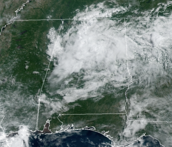
We are seeing a more clouds than sun, with temperatures in the 70s, but where there is more sun, temps are heading into the 80s. Heading through the rest of today, more showers and storms will develop across the Alabama landscape due to heat and moisture producing ample instability to fuel convection.
TOMORROW/THURSDAY: These two days will be very muggy as tropical moisture remains in place, meaning both days will feature scattered, mostly afternoon and evening showers and thunderstorms. Pretty routine for summertime in Alabama, before the storms get going each day, expect a mix of sun and clouds with highs in the upper 80s.
IN THE TROPICS: Danny has come and gone, but we continue to watch the Atlantic as there are two more features.
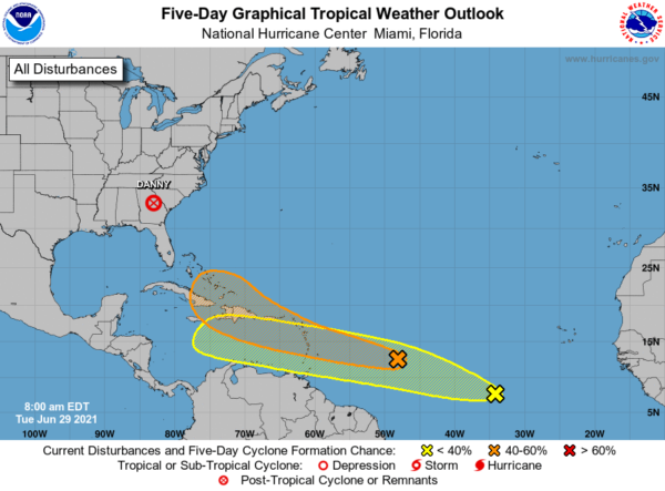
1. Disorganized showers and thunderstorms continue in association with a tropical wave located over the tropical Atlantic, about 850 miles east of the Lesser Antilles. Some slow development of this disturbance is possible later this week and this weekend while the system moves westward to west-northwestward at 15 to 20 mph, likely reaching the Lesser Antilles by Wednesday night. Formation chance through 5 days…medium…40 percent.
2. Shower activity associated with a tropical wave located about 800 miles southwest of the Cabo Verde islands has become a little better organized since yesterday. Additional slow development of this system is possible during the next several days as it moves generally west-northwestward at about 20 mph. Formation chance through 5 days…low…20 percent.
The next two names on the list are Elsa and Fred.
BEACH FORECAST CENTER: Get the latest weather and rip current forecasts for the beaches from Fort Morgan to Panama City on our Beach Forecast Center page. There, you can select the forecast of the region that you are interested in visiting.
WORLD TEMPERATURE EXTREMES: Over the last 24 hours, the highest observation outside the U.S. was 125.8F at Jahra, Kuwait. The lowest observation was -104.4F at Vostok, Antarctica.
CONTIGUOUS TEMPERATURE EXTREMES: Over the last 24 hours, the highest observation was 126F at Death Valley, CA. The lowest observation was 30F at Berthoud Pass, CO.
WEATHER ON THIS DATE IN 1954: Hurricane Alice dumped as much as 27 inches of rain on the Lower Rio Grande Valley of Texas. The Rio Grande River at Laredo reached a level 12.6 feet above its previous highest mark, and the roadway of the U.S. 90 bridge was thirty feet below the high water.
Category: Alabama's Weather, ALL POSTS
About the Author (Author Profile)
Macon, Georgia Television Chief Meteorologist, Birmingham native, and long time Contributor on AlabamaWX. Stormchaser. I did not choose Weather, it chose Me. College Football Fanatic. @Ryan_StinnetSubscribe
If you enjoyed this article, subscribe to receive more just like it.


