

We Now Have PTC-5 On The Board Over the Tropical Atlantic
SUMMARY OF 500 PM AST…2100 UTC…INFORMATION
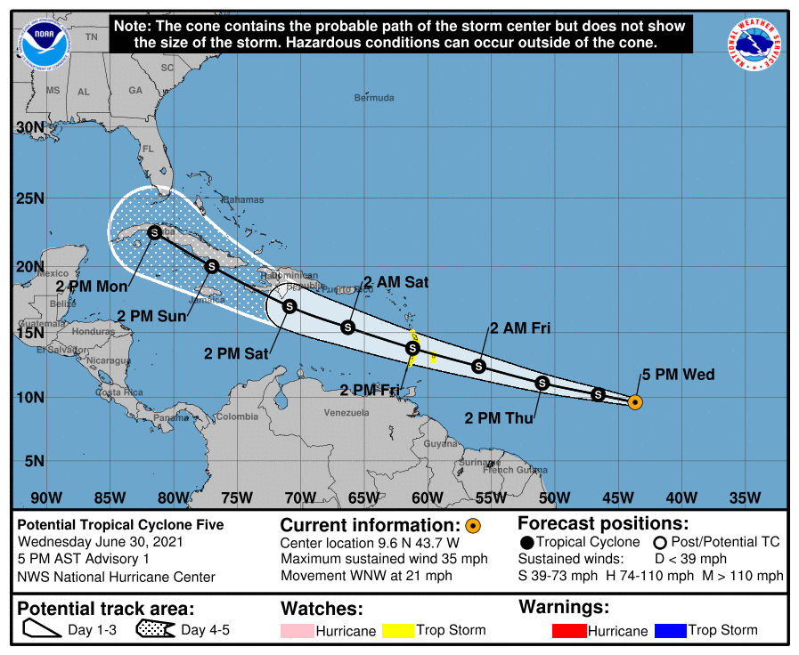
LOCATION…9.6N 43.7W
ABOUT 1195 MI…1920 KM E OF THE WINDWARD ISLANDS
MAXIMUM SUSTAINED WINDS…35 MPH…55 KM/H
PRESENT MOVEMENT…WNW OR 285 DEGREES AT 21 MPH…33 KM/H
MINIMUM CENTRAL PRESSURE…1008 MB…29.77 INCHES
SUMMARY OF WATCHES AND WARNINGS IN EFFECT
A Tropical Storm Watch is in effect for…
* St. Vincent and the Grenadines
* St. Lucia
* Barbados
* Martinique
FORECAST DISCUSSION
Satellite imagery indicates that the convection associated with the low pressure area over the central tropical Atlantic is becoming better organized. However, earlier scatterometer data showed that the circulation was elongated and not well defined. Since the system is about 48 h away from the Lesser Antilles and is expected to become a tropical storm before reaching the islands, advisories are being initiated at this time on Potential Tropical Cyclone Five. The initial intensity is set to 30 kt based on the scatterometer data and satellite intensity estimates from TAFB and SAB.
The initial motion is 285/18. The disturbance is currently on the south side of a strong subtropical ridge, and for the next 72 h the system should move rapidly west-northwestward. Indeed, the forward speed may exceed 25 kt as the system moves through the Lesser Antilles. There is excellent agreement in the guidance on this part of the forecast track. After 72 h, the system is expected to approach a weakness in the ridge caused by a mid-latitude trough over the eastern United States. The should cause the system to slow its forward speed and turn more northwestward. The track guidance become more diverse during this time in regards to how far north the system will turn, and this part of the NHC forecast track is most similar to the GFS and UKMET forecasts. Note that the track forecast is more uncertain than usual since the system does not yet have a well-defined center.
The disturbance is currently in a favorable upper-level wind pattern. However, most Atlantic systems in this area moving near 25 kt have trouble strengthening, and there are indications that the fast forward speed may produce some westerly shear. Thus, the NHC intensity forecast for the first 72 h is near the lower edge of the intensity guidance. After 72 h, the intensity forecast becomes highly uncertain due to possible land interaction and differences in the model forecasts of the upper-level winds. This portion of the NHC intensity forecast maintains a constant 50-kt intensity due to the level of uncertainty.
KEY MESSAGES
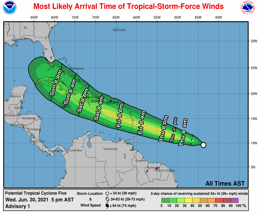
1. The system is expected to become a tropical storm before reaching the Lesser Antilles and tropical storm conditions are possible beginning Friday in portions of the Windward and southern Leeward Islands.
2. Heavy rainfall will move quickly across the Windward and southern Leeward Islands, including Barbados, on Friday. Isolated flash flooding and mudslides are possible.
3. There is a risk of wind and rainfall impacts in portions of the Virgin Islands, Puerto Rico, Hispaniola, Cuba, the Turks and Caicos and the southeastern Bahamas through early next week, although the forecast is more uncertain than usual since the system does not have a well-defined center. Interests in these areas should monitor the system’s progress and updates to the forecast.
4. Interests in Florida should monitor updates to the forecast for this system, but it is too soon to determine what if any impacts could occur there next week given the uncertainty in the long-range forecast.
About the Author (Author Profile)
Scott Martin is an operational meteorologist, professional graphic artist, musician, husband, and father. Not only is Scott a member of the National Weather Association, but he is also the Central Alabama Chapter of the NWA president. Scott is also the co-founder of Racecast Weather, which provides forecasts for many racing series across the USA. He also supplies forecasts for the BassMaster Elite Series events including the BassMaster Classic.Subscribe
If you enjoyed this article, subscribe to receive more just like it.


