

Hurricane Watch Issued for Eastern Cuba as Elsa Moves Through the Eastern Caribbean Sea
SUMMARY OF 500 PM AST…2100 UTC…INFORMATION
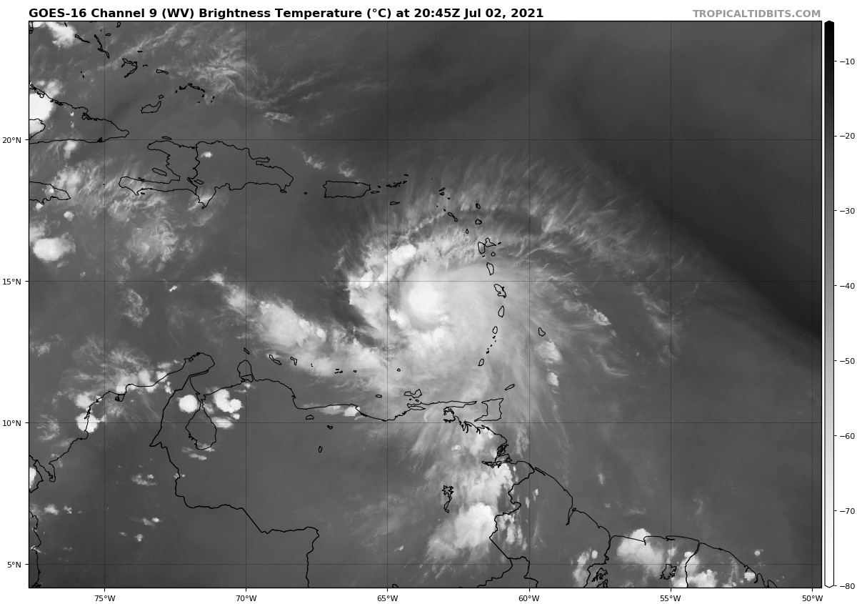
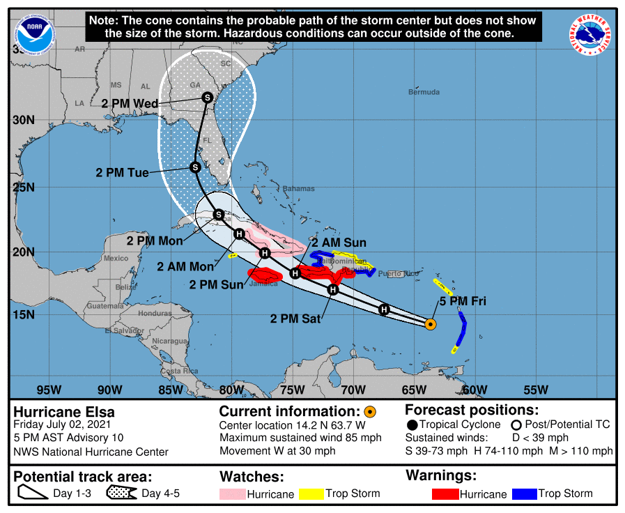
LOCATION…14.2N 63.7W
ABOUT 505 MI…815 KM SE OF SANTO DOMINGO, DOMINICAN REPUBLIC
ABOUT 180 MI…290 KM WNW OF ST. VINCENT
MAXIMUM SUSTAINED WINDS…85 MPH…140 KM/H
PRESENT MOVEMENT…W OR 280 DEGREES AT 30 MPH…48 KM/H
MINIMUM CENTRAL PRESSURE…991 MB…29.27 INCHES
WATCHES AND WARNINGS
A Hurricane Warning is in effect for…
* Southern coast of the Dominican Republic from Punta Palenque to the border with Haiti
* Southern portion of Haiti from Port-au-Prince to the southern border with the Dominican Republic
* Jamaica
A Tropical Storm Warning is in effect for…
* St. Vincent and the Grenadines
* St. Lucia
* Martinique
* The coast of Haiti north of Port-au-Prince
* South coast of the Dominican Republic east of Punta Palenque to Cabo Engano
A Hurricane Watch is in effect for…
* The Cuban provinces of Camaguey, Granma, Guantanamo, Holguin, Las Tunas, and Santiago de Cuba
A Tropical Storm Watch is in effect for…
* Grenada and its dependencies
* Saba and Sint Eustatius
* North coast of the Dominican Republic from Cabo Engano to Bahia de Manzanillo
* Cayman Brac and Little Cayman
Interests elsewhere in the Windward Islands, Leeward Islands, the Virgin Islands, Puerto Rico, the Dominican Republic, Cuba, and the Cayman Islands should monitor the progress of Elsa. Additional watches and warnings will likely be required tonight.
FORECAST DISCUSSION
Reports from a NOAA Hurricane Hunter aircraft indicate that Elsa has strengthened a little more since the last advisory, with a combination of flight-level winds, SFMR surface wind estimates, and dropsonde data showing that the maximum winds are near 75 kt. The aircraft also reported that the 700-mb circulation remains somewhat disorganized, and that the 700-mb center is not vertically aligned with the surface center. The former issue is likely due to the rapid motion, and the latter may be due to the effects of westerly shear.
The initial motion now is 290/26. There is again little change to the forecast track or the forecast guidance. The guidance is in good agreement on a rapid west-northwestward notion to near the south coast of the Dominican Republic and Haiti by 24-30 h, followed by a continued west-northwestward motion at a slower forward speed through 48 h. After that time, Elsa should gradually turn northwestward and eventually northward as it moves through a weakness in the subtropical ridge created by a mid-latitude trough over the eastern United States. This motion should take the cyclone across Cuba and over the eastern Gulf of Mexico or the nearby Florida Peninsula, eventually moving into the southeastern United States by the end of the period. The track guidance is a little less divergent than earlier, but there is still enough spread in the potential tracks that this part of the forecast remains low confidence.
The latest global model runs and the associated intensity guidance are forecasting a less favorable environment for Elsa during the next several days. The SHIPS model now calls for 10-20 kt of northwesterly shear during the next 48 h, and 15-25 kt of shear after 60 h. In addition, the 12Z GFS forecasts a considerably weaker storm than its last several runs. The intensity forecast thus calls for little change in strength during the first 24 h, although it is possible the hurricane could strengthen a little more during that time. After that, land interaction and shear are likely to cause weakening until Elsa emerges into the Gulf of Mexico. However, the HWRF still calls for Elsa to intensify into a Category 3 hurricane, and like the track forecast the intensity forecast remains of low confidence due to the spread in the guidance.
It should be noted that the average NHC track errors are 175 miles and 200 miles at days 4 and 5, respectively. Given the larger-than-normal uncertainty and because hazards will extend well away from the center of the storm, users are urged to not focus on the exact forecast points.
KEY MESSAGES
1. Hurricane conditions and dangerous storm surge are expected within the Hurricane Warning areas in Haiti and the Dominican Republic beginning Saturday, and in Jamaica beginning Sunday.
2. Heavy rainfall will gradually subside across the Windward and southern Leeward Islands tonight, including Barbados. Outer rain bands will impact Puerto Rico by late tonight, and affect southern Hispaniola and Jamaica Saturday into Sunday. Isolated to scattered flash flooding and mudslides are possible. By early next week, heavy rain will impact the Cayman Islands and Cuba. Significant flooding and mudslides are possible.
3. Hurricane conditions and dangerous storm surge are possible in portions of eastern Cuba beginning early Sunday, where a Hurricane Watch is in effect. There is an increasing risk of wind, storm surge, and rainfall impacts elsewhere in Cuba Sunday and Monday.
4. There is an increasing risk of storm surge, wind, and rainfall impacts beginning Monday in the Florida Keys and spreading northward along the Florida Peninsula through Tuesday. However, the forecast uncertainty remains larger than usual due to Elsa’s potential interaction with the islands of Hispaniola and Cuba this weekend. Interests throughout Florida should monitor Elsa’s progress and updates to the forecast.
Category: ALL POSTS, Severe Weather, Tropical
About the Author (Author Profile)
Scott Martin is an operational meteorologist, professional graphic artist, musician, husband, and father. Not only is Scott a member of the National Weather Association, but he is also the Central Alabama Chapter of the NWA president. Scott is also the co-founder of Racecast Weather, which provides forecasts for many racing series across the USA. He also supplies forecasts for the BassMaster Elite Series events including the BassMaster Classic.Subscribe
If you enjoyed this article, subscribe to receive more just like it.


