

4 pm Update: A Weaker Elsa is Moving Over Western Cuba
SUMMARY OF 4 PM CDT…2100 UTC…INFORMATION
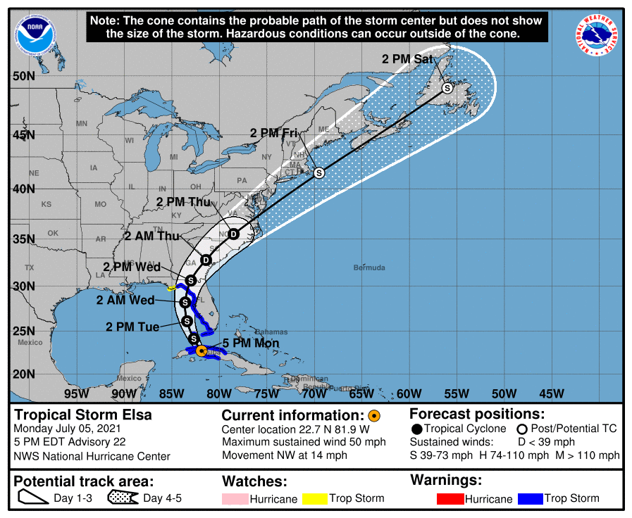
LOCATION…22.7N 81.9W
ABOUT 45 MI…75 KM SE OF HAVANA CUBA
ABOUT 130 MI…210 KM S OF KEY WEST FLORIDA
MAXIMUM SUSTAINED WINDS…50 MPH…85 KM/H
PRESENT MOVEMENT…NW OR 315 DEGREES AT 14 MPH…22 KM/H
MINIMUM CENTRAL PRESSURE…1008 MB…29.77 INCHES
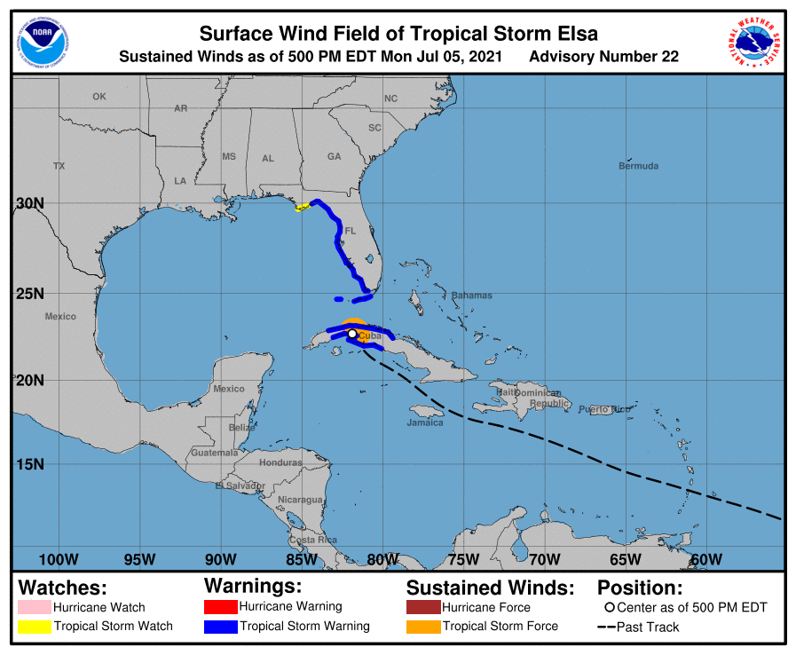
WATCHES AND WARNINGS
A Storm Surge Warning is in effect for…
* West coast of Florida from Bonita Beach to the Aucilla River including Tampa Bay
A Tropical Storm Warning is in effect for…
* The Cuban provinces of Cienfuegos, Matanzas, Villa Clara, Mayabeque, Havana, and Artemisa
* The Florida Keys from Craig Key westward to the Dry Tortugas
* West coast of Florida from Flamingo northward to Ochlockonee River
A Storm Surge Watch is in effect for…
* West of the Aucilla River to the Ochlockonee River
A Tropical Storm Watch is in effect for…
* West of the Ochlockonee River to Indian Pass, Florida
FORECAST DISCUSSION & OUTLOOK
Satellite and radar imagery along with surface synoptic observations indicate that the tropical cyclone moved inland over west-central Cuba around 1800 UTC, accompanied by very heavy rains. Assuming that some weakening has occurred due to the influence of land, the advisory intensity is set to 45 kt. An Air Force Hurricane Hunter aircraft is scheduled to investigate Elsa this evening after the center moves into the Florida Straits and will provide a better assessment of the system’s intensity.
The storm appears to be continuing on its northwestward track and the initial motion estimate is 315/12 kt. There are no changes to the track forecast reasoning from the previous advisory. Elsa should move between the western portion of a mid-level subtropical ridge extending westward from the Atlantic and a broad low pressure area near the northwestern Gulf of Mexico coast for the next couple of days. Later in the forecast period, the system is likely to accelerate northeastward and move from the eastern United States to near Atlantic Canada. The NHC track forecast over the eastern Gulf of Mexico is practically identical to the one from the previous advisory, and a little to the left of the previous one over the eastern United States and the Atlantic. This is in good agreement with the now tightly-clustered track model guidance.
Some restrengthening of the cyclone is likely after it moves into the Gulf of Mexico, but vertical shear associated with a broad upper-level trough over the Gulf is likely to limit intensification. The official intensity forecast is slightly above the latest model consensus, IVCN. Around 96 hours, the global models suggest that the cyclone will merge with a frontal zone, so the forecast shows extratropical transition at that time.
KEY MESSAGES
1. Heavy rain will impact the Cayman Islands and Cuba through tonight resulting in significant flooding and mudslides over Cuba. As Elsa approaches the Florida Keys, Florida Peninsula, and southeast Georgia through Wednesday, heavy rainfall may result in isolated flash, urban, and minor river flooding, with considerable flooding possible in southwest and western portions of Florida. Mid- to late-week, heavy rains across coastal South Carolina, North Carolina, and southeastern Virginia may result in isolated flash and urban flooding.
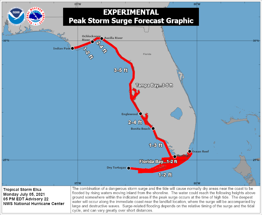
2. There is a danger of life-threatening storm surge along portions of the west coast of Florida Tuesday night and Wednesday, and a Storm Surge Warning has been issued for that area.
3. Tropical storm conditions are expected to continue across portions of central and western Cuba tonight, and spread northward across portions of the Florida Keys and the Florida west coast through Wednesday, where a Tropical Storm Warning is in effect.
4. There is a risk of tropical storm conditions along portions of the coasts of Georgia and the Carolinas Wednesday and Thursday.
Category: ALL POSTS, Severe Weather, Tropical
About the Author (Author Profile)
Scott Martin is an operational meteorologist, professional graphic artist, musician, husband, and father. Not only is Scott a member of the National Weather Association, but he is also the Central Alabama Chapter of the NWA president. Scott is also the co-founder of Racecast Weather, which provides forecasts for many racing series across the USA. He also supplies forecasts for the BassMaster Elite Series events including the BassMaster Classic.Subscribe
If you enjoyed this article, subscribe to receive more just like it.


