

Occasional Showers Through Tomorrow; Drier This Weekend
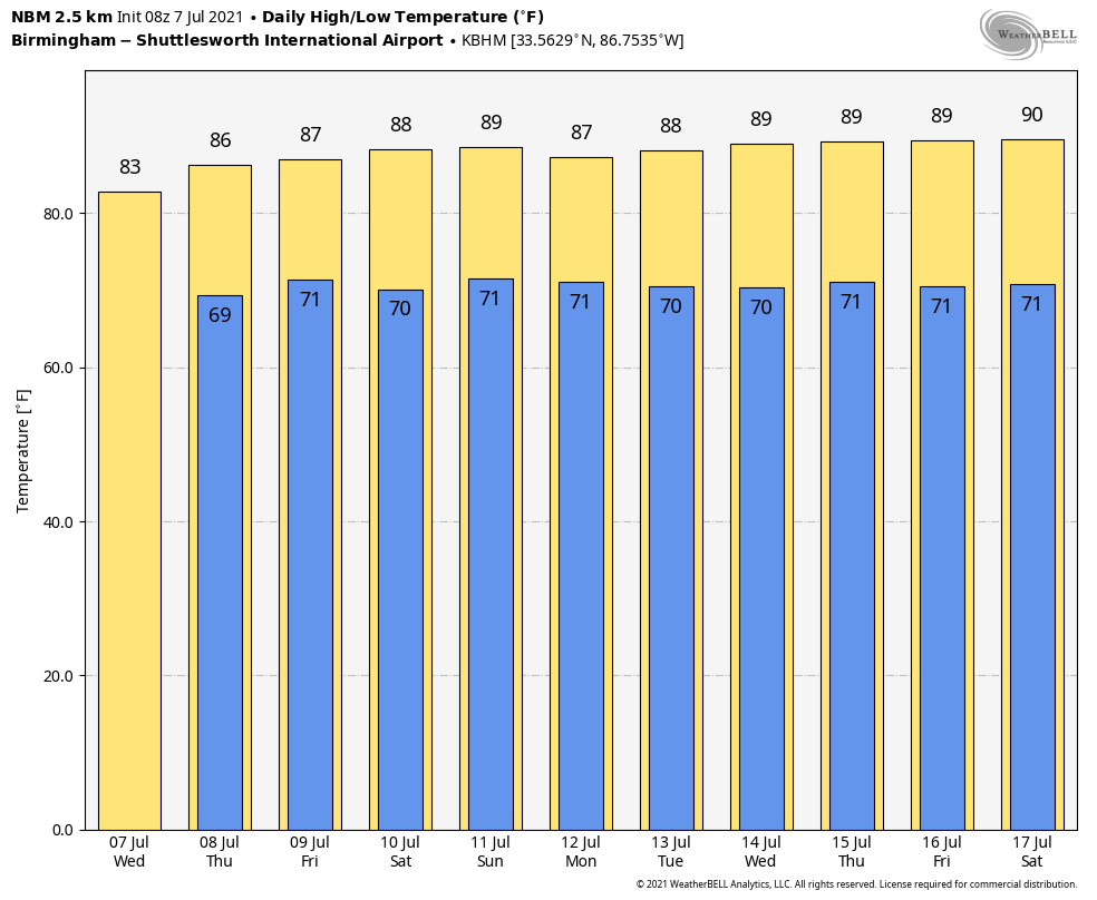
RADAR CHECK: We have large areas of rain on radar this morning across Alabama as an upper trough continues to interact with a very moist airmass. The overall setup won’t change much through tomorrow… the sky will be mostly cloudy with periods of rain and a few thunderstorms likely statewide. Temperatures will likely hold in the 70s all day today, and the high tomorrow will be in the low to mid 80s with only a very limited amount of sun. Temperatures reach the mid 80s Friday with intervals of sun along with scattered to numerous showers and thunderstorms. Rain amounts of around one inch are likely through Friday, but some spots could see more where heavier downpours develop.
THE ALABAMA WEEKEND: Precipitable water values will come down, the air will be drier, and showers and storms will be thinning out Saturday and Sunday. Look for a partly sunny sky both days with just a few widely scattered showers and storms around during the afternoon and evening hours. Odds of any one spot getting wet both days are 20-30 percent, and highs will be mostly in the upper 80s…. still a little below average for mid-July in Alabama.
NEXT WEEK: For now, it looks like we will be dealing with pretty routine summer weather through the week. Partly sunny days with the threat of ransom, scattered showers and storms most days from around 1:00 until 11:00 p.m. Afternoon highs will remain mostly in the upper 80s… See the Weather Xtreme video for maps, graphics, and more details.
ELSA: Elsa weakened to a tropical storm overnight; top winds are down to 65 mph, and the center is about 70 miles west/northwest of Tampa. Landfall comes later today near Cedar Key… from there the system moves through South Georgia, and across the eastern parts of the Carolinas.
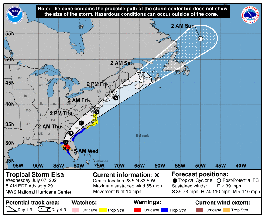
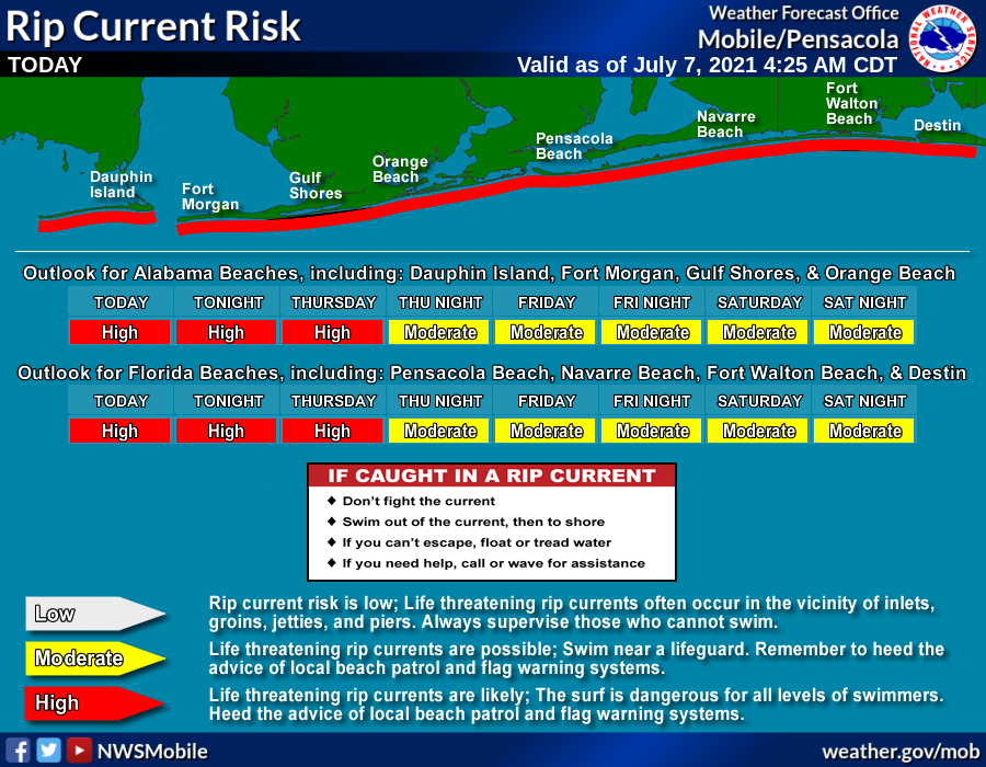
Wet and breezy weather continues over North Florida Peninsula this morning, and a tornado watch is in effect as well.The direct impacts of Elsa remain east of the Central Gulf Coast (Gulf Shores, Pensacola, Destin, Panama City Beach)… but there will be a high danger of rip currents today and tomorrow. The surf will settle down by Friday and the weekend.
The rest of the Atlantic basin is very quiet, and additional tropical storm formation is not expected through early next week.
RAIN UPDATE: Here are rain totals for the year so far, and the departure from average…
Mobile 46.20″ (+11.53″)
Tuscaloosa 41.74″ (+12.30″)
Birmingham 37.08″ (+5.60″)
Dothan 34.56″ (+6.29″)
Muscle Shoals 33.83″ (+3.75″)
Huntsville 33.39″ (+3.31″)
Montgomery 30.69″ (+3.00″)
Anniston 29.04″ (-0.32″)
ON THIS DATE IN 2004: A tornado occurred in the Rockwell Pass area of Sequoia National Park, California. Since the elevation of the tornado’s ground circulation was approximately 3705 m (12,156 ft) MSL, this is the highest-elevation tornado documented in the United States.
BEACH FORECAST: Click here to see the AlabamaWx Beach Forecast Center page.
WEATHER BRAINS: Don’t forget you can listen to our weekly 90 minute show anytime on your favorite podcast app. This is the show all about weather featuring many familiar voices, including our meteorologists here at ABC 33/40.
CONNECT: You can find me on all of the major social networks…
Look for the next Weather Xtreme video here by 3:00 this afternoon… enjoy the day!
Category: ALL POSTS, Weather Xtreme Videos, WeatherBrains
About the Author (Author Profile)
James Spann is one of the most recognized and trusted television meteorologists in the industry. He holds the AMS CCM designation and television seals from the AMS and NWA. He is a past winner of the Broadcast Meteorologist of the Year from both professional organizations.Subscribe
If you enjoyed this article, subscribe to receive more just like it.


