

10 pm Update: Elsa Approaching Chesapeake Bay
SUMMARY OF 10 PM CDT…0300 UTC…INFORMATION
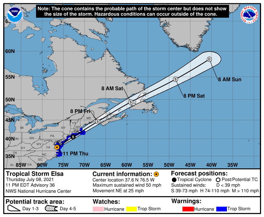
LOCATION…37.6N 76.5W
ABOUT 50 MI…80 KM NNW OF NORFOLK VIRGINIA
ABOUT 170 MI…270 KM SW OF ATLANTIC CITY NEW JERSEY
MAXIMUM SUSTAINED WINDS…50 MPH…85 KM/H
PRESENT MOVEMENT…NE OR 45 DEGREES AT 25 MPH…41 KM/H
MINIMUM CENTRAL PRESSURE…1002 MB…29.59 INCHES
WATCHES AND WARNINGS
A Tropical Storm Warning is in effect for…
* Ocracoke Inlet, North Carolina to Sandy Hook, New Jersey
* Pamlico and Albemarle Sounds
* Chesapeake Bay south of North Beach and the tidal Potomac south of Cobb Island
* Delaware Bay south of Slaughter Beach
* Long Island from East Rockaway Inlet to the eastern tip along the south shore and from Port Jefferson Harbor eastward on the north shore
* New Haven, Connecticut to Merrimack River, Massachusetts including Cape Cod, Block Island, Martha’s Vineyard, and Nantucket
DISCUSSION AND OUTLOOK
Elsa has become slightly better organized this evening. Convection near the center of Elsa has deepened, and the surface pressures have fallen a few mb since this afternoon based on observations over eastern Virginia. Although there are no wind reports above 40 kt during the past several hours, recent Doppler velocity data shows stronger winds offshore of the mid-Atlantic states, so the initial wind speed will remain 45 kt.
It appears that the early stages of extratropical transition have begun with Elsa, with almost all of the deep convection north of the center. A shortwave moving out of the Great Lakes should cause the storm to deepen on Friday but also expand in size,resulting in the maximum winds staying about the same as they are now. Elsa should transition into an extratropical cyclone within 24 hours due to the shortwave and cold waters south of New England, and then gradually weaken over Atlantic Canada and northeast of Newfoundland after it loses its baroclinic support. The new intensity forecast is similar to the previous one and the consensus of the global models.
The storm is moving faster to the northeast this evening and will gradually accelerate northeastward during the next day or two due to speedy mid-latitude southwesterly flow ahead of a broad mid-tropospheric trough over the eastern North America. Elsa should move over southeastern New England and Atlantic Canada within the next 12-36 hours. The model guidance remains tightly packed on that solution, and the new official track forecast remains close to the previous one.
KEY MESSAGES
1. As Elsa moves across the eastern mid-Atlantic overnight, heavy rainfall may result in limited flash and urban flooding. Heavy rainfall across New England through Friday could lead to considerable flash and urban flooding.
2. Tropical storm conditions should continue along portions of the mid-Atlantic coast overnight. Tropical storm conditions are expected in portions of the southern New England states and New York by Friday. Gusty winds are expected over portions of Atlantic Canada Friday night and Saturday.
All images, forecasts, and documents are courtesy of their respective publishers.
Category: ALL POSTS, Severe Weather, Tropical
About the Author (Author Profile)
Scott Martin is an operational meteorologist, professional graphic artist, musician, husband, and father. Not only is Scott a member of the National Weather Association, but he is also the Central Alabama Chapter of the NWA president. Scott is also the co-founder of Racecast Weather, which provides forecasts for many racing series across the USA. He also supplies forecasts for the BassMaster Elite Series events including the BassMaster Classic.Subscribe
If you enjoyed this article, subscribe to receive more just like it.


