

Potential for More Flooding Issues This Morning in Central Alabama
With moderate to heavy rainfall slowly moving over already waterlogged locations, there will continue to be the threat of some flooding issued across portions of Central Alabama, especially over the southwestern corner of the area. Here is the latest Hazardous Weather Outlook from NWS Birmingham:
Periods of heavy rain at times may occur through tonight across portions of Central Alabama. This could cause isolated areas of flooding and ponding of water in low-lying areas. Use caution and allow extra time for travel.
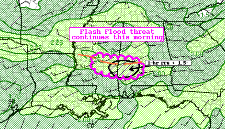
The top image is from the WPC from their latest Mesoscale Precipitation Discussion. Here is what that discussion stated:
Summary… Heavy rainfall continues this morning over portions of central Mississippi into far west-central Alabama, with some hourly rain totals up to 1.5 inches. Some instances of flash flooding remain possible.
Discussion… A weak mid/upper level impulse moving through the larger scale troughing over the region combined with an effective boundary in place is providing the large scale forcing needed to maintain early morning convection across central MS into far western AL. The environment continues to be supportive of high efficiency thunderstorms and intense rain rates. The latest mesoanalysis shows pockets of 1000-1500 J/kg of SBCAPE within an axis of seasonably PWs ranging from 1.9 to 2.2 inches.
A subtle increase in the moisture transport and inflow with this associated weak impulse in the favorable environment will continue to support the convection through the morning hours as the organized line sags south/southeast. The increasing west/east orientation aligning with the mean flow will help further increase the duration of potential heavy rain and could result in repeating/training episodes. While there is some southward movement now, there remains the possibility that convection will track over areas that already have picked up quite a bit of rainfall this morning.
The 10Z HRRR was handling the current situation fairly well and suggests the potential for an additional 1 to locally 3 inches in the MPD area will be possible. Hourly rain totals up to 1.5 inches will be possible. Much of the region is experiencing high soil moisture saturation, as shown by the 0-100 cm soil percentiles above 98 percent (NASA SPoRT). As a result, the combination of heavy rainfall over more saturated soils could lead to instances of flash flooding this morning.
Category: Alabama's Weather, ALL POSTS
About the Author (Author Profile)
Scott Martin is an operational meteorologist, professional graphic artist, musician, husband, and father. Not only is Scott a member of the National Weather Association, but he is also the Central Alabama Chapter of the NWA president. Scott is also the co-founder of Racecast Weather, which provides forecasts for many racing series across the USA. He also supplies forecasts for the BassMaster Elite Series events including the BassMaster Classic.Subscribe
If you enjoyed this article, subscribe to receive more just like it.


